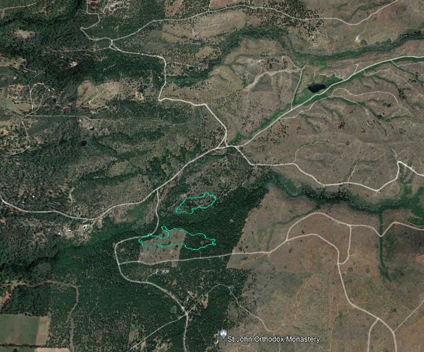
#ForwardFire in Tehama Co east of #Manton, near Ponderosa Way & Forward Rd: 2-3 acres in timber w/ moderate rate of spread, 2 additional large air tankers requested. Spot fire now visible on cameras too. share.watchduty.org/incident/1311
#ForwardFire (#Manton, Tehama Co) - Significant increase in smoke seen on cameras, however no updated report on conditions heard recently. The cam from the first tweet has been down for a good 30+ mins.
#ForwardFire (#Manton, Tehama Co) - 75 acres which includes 2 main areas of fire w/ multiple spot fires out in front per radio traffic, Air Attack requesting 1 addl S-2 tanker & 3 additional large air tankers.
#ForwardFire (#Manton, Tehama Co) - IC confirming 75 acres w/ critical rate of spread & 2 heads of fire, large ground resource order to be placed soon.
#ForwardFire (#Manton, Tehama/Shasta Co) - Should add that this originated right near the county line & could very well be into Shasta Co already given proximity & growing size of fire (this is why the Watch Duty event just got upgraded to include Shasta Co too).
#ForwardFire (#Manton, Tehama/Shasta Co) - FIRIS is overhead & mapped the fire in the last 10 mins or so, revised to 24 acres. The southern fire is 16 acres, the northern is 8 acres.
#ForwardFire (#Manton, Tehama/Shasta Co) - Air Attack ordering 2 VLATs + a lead plane - these have been available at McClellan as the Mosquito fire hasn't had the opportunity to use them w/ the current smoke conditions on that fire. Evacs in progress for the area.
#ForwardFire (#Manton, Tehama/Shasta Co) - IC updating to 35-40 acres currently. Evacuations per CAL FIRE TGU: Mandatory evacuations north of Forward Rd and east of Ponderosa Way. Evacuations warnings for the Rock Creek Road area.
#ForwardFire (#Manton, Tehama/Shasta Co) - FIRIS has mapped the fire at 95 acres, timestamped 16:57 hours. The fires have now merged w/ spots visible. Large amount of air tankers assigned to this one.
#ForwardFire (#Manton, Tehama/Shasta Co) - IC reported that the fire is still approx 95 acres w/ moderate rate of spread & spot fires out in front still.
#ForwardFire (#Manton, Tehama/Shasta Co) - FIRIS has mapped the fire at 160 acres as of 11:52pm tonight. List of evacs in the app > share.watchduty.org/incident/1311

• • •

Missing some Tweet in this thread? You can try to force a refresh
 

Keep Current with CA Fire Scanner

CA Fire Scanner Profile picture

Stay in touch and get notified when new unrolls are available from this author!

Read all threads

This Thread may be Removed Anytime!

PDF

Twitter may remove this content at anytime! Save it as PDF for later use!

Try unrolling a thread yourself!

how to unroll video
  1. Follow @ThreadReaderApp to mention us!

  2. From a Twitter thread mention us with a keyword "unroll"
@threadreaderapp unroll

Practice here first or read more on our help page!

More from @CAFireScanner

Sep 10
#MosquitoFire (#Foresthill, Placer Co/El Dorado Co) - From the townhall meeting: they were lucky today w/ the inversion & smoke setting in for the day: didn't see that extreme fire behavior from yesterday. ~2,000 firefighters being moved in to the fire.
#MosquitoFire - Branch 5 (Foresthill) has been holding really good. They've been able to do some mop up in there today & get more lines in around Foresthill. They were able to get into Branch 20 (Volcanoville) to do some mopup around structures, looking to get some line in there.
#MosquitoFire - They've been doing a lot of scouting in the areas towards the east. It's big country & a lot of steep drainages. From the fire behavior analyst: yesterday at 12pm it was 8,000 acres. Temp was 95, RH was 15% & winds were 6mph. That resulted in a 21,000 acre growth.
Read 6 tweets
Sep 8
(Mosquito) - You may have seen this in the @watchdutyapp. This was my error & mine only. I lapsed in concentration while editing/creating the map on the Google My Maps platform & the perimeter was not where it was supposed to be. I sincerely apologize for that. Image
We've been looking for ways to provide maps in a simple format that people can view & scroll, without having to view older perimeters of the same fire. This appeared to be a good solution but is currently being reviewed for better processes & to ensure it doesn't happen again.
I can tell you that any information (scanner info, maps etc) I provide is in good faith, to the best of my ability. I never ever want to mislead anyone. No excuses. I apologize again to anybody who was able to view it in the time that it was available prior to being removed.
Read 4 tweets
Sep 8
#FairviewFire (S/O #ValleVista, Riverside Co) - Significant push to the west now w/ multiple spot fires across west side of Fairview Ave from the origin to Fairview Ave @ Bautista Canyon Rd. Resources in there trying to catch spots.
#FairviewFire (S/O #ValleVista, Riverside Co) - They've managed to pick up the spot fires for now, resources maneuvering for structure defense too. There will be night copters assigned tonight per radio traffic.
#FairviewFire (S/O #ValleVista, Riverside Co) - This piece of fire is making a hard push in the flats towards Fairview Ave again (not sure from which side) w/ an immediate life threat, air support requested. Will impact the road & a dead grove in about 5 minutes.
Read 4 tweets
Sep 7
#ForkFire in #NorthFork, Madera Co: 50 acres w/ potential for 200 acres, fire has jumped the North Fork Willow Creek, AA430 requesting 4 additional tankers closest any type. Rd 222 south of N Fork Rd. share.watchduty.org/incident/1285 Image
#ForkFire (#NorthFork, Madera Co) - IC requesting 10 addl type 3 engines, 10 any type closest engines, 3 dozers, 4 handcrews, 4 water tenders. 2 addl copters. Going to an extended attack w/ potential for major incident per IC. Image
#ForkFire (#NorthFork, Madera Co) - AA430 requesting 1 VLAT + placing a no divert on 2 of the tankers due to life threat. Sheriff's & CHP requested for evacuations in the area.
Read 12 tweets
Aug 2
#McKinneyFire (Klamath NF, Siskiyou Co) - From the community meeting: completed dozer line around Yreka. They have a dozer line up on the hill along the ridge system & a secondary line closer to town. Received precipitation throughout the day on the eastern side.
#McKinneyFire - Crews are also directly on the fires edge closest to Yreka building a combo of hand line + dozer line, have good line around Humbug Creek & working from there to the west. Working in Baldy Cap, copters in there now, mixed conditions due to smoke & weather.
#McKinneyFire - Using aircraft where possible. They're working towards Baker Flat & have dozer line across the ridge system north of Fort Jones as a secondary line. Scott Bar: handline going in there, working towards Mill Creek.
Read 8 tweets
Jul 31
#PebbleFire in eastern Fresno Co is 30 acres w/ moderate ROS, 3 structures involved & several civilian burn injuries, requiring an air ambulance. Has been ongoing for about an hour now. Ripple Ln & Pebble Ln. share.watchduty.org/incident/858
#PebbleFire (#SquawValley, Fresno Co) - 40 acres per CAL FIRE. There was two burned civilians & both air ambulances got cancelled - 1 ground ambulance was able to handle & transport both. Not hearing much - stuck listening to a very long weather readout..
#PebbleFire (#SquawValley, Fresno Co) - IC reporting little active fire left & it remains about 40 acres, AA will be releasing the tankers & will continue to work w/ the copters.
Read 5 tweets

Did Thread Reader help you today?

Support us! We are indie developers!


This site is made by just two indie developers on a laptop doing marketing, support and development! Read more about the story.

Become a Premium Member ($3/month or $30/year) and get exclusive features!

Become Premium

Don't want to be a Premium member but still want to support us?

Make a small donation by buying us coffee ($5) or help with server cost ($10)

Donate via Paypal

Or Donate anonymously using crypto!

Ethereum

0xfe58350B80634f60Fa6Dc149a72b4DFbc17D341E copy

Bitcoin

3ATGMxNzCUFzxpMCHL5sWSt4DVtS8UqXpi copy

Thank you for your support!

Follow Us on Twitter!

:(