Tim Ehrhart Profile picture
Sep 16 5 tweets 3 min read
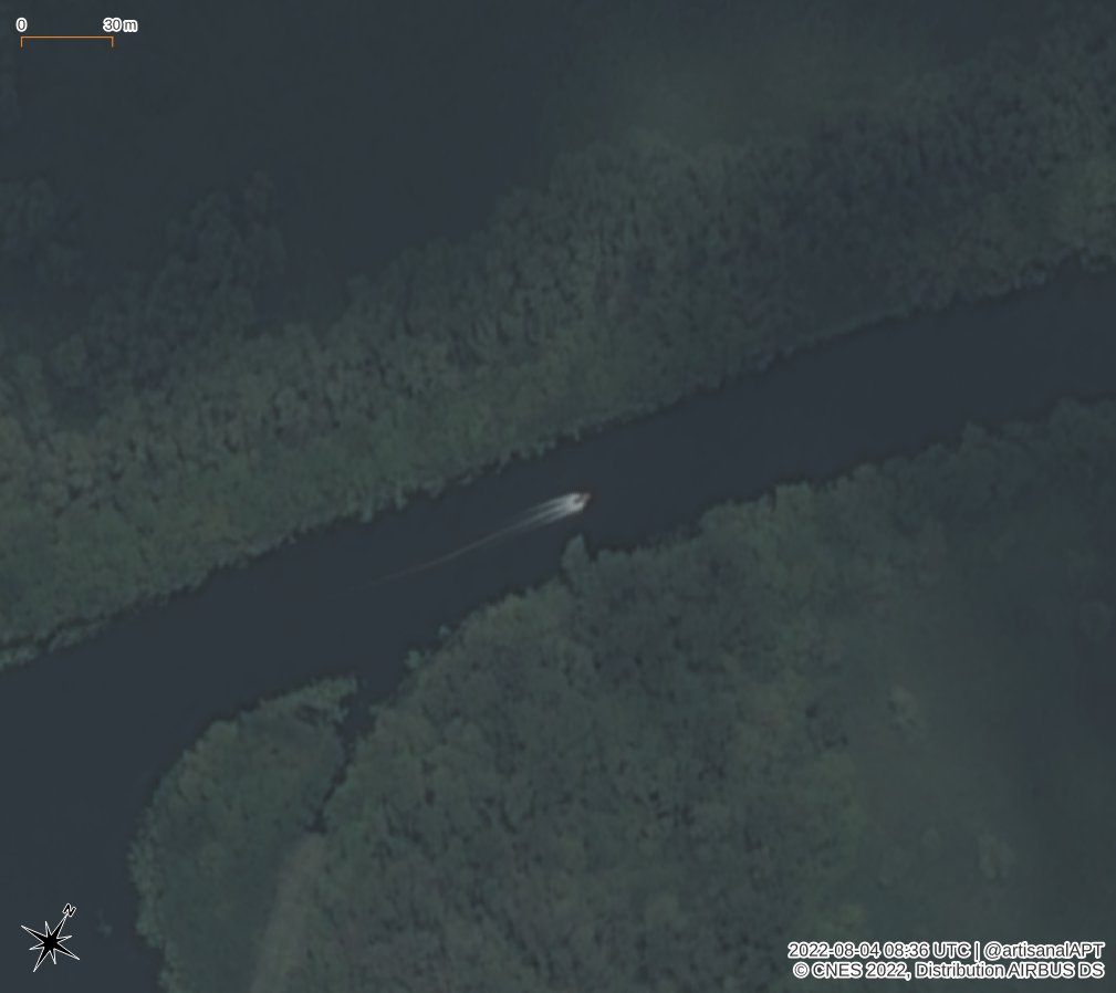
Situation around #antonovskiybridge in #Kherson hasn't changed. Sep 15 images show the ferries in use nearby, and empty barges. But... 🧵 1/
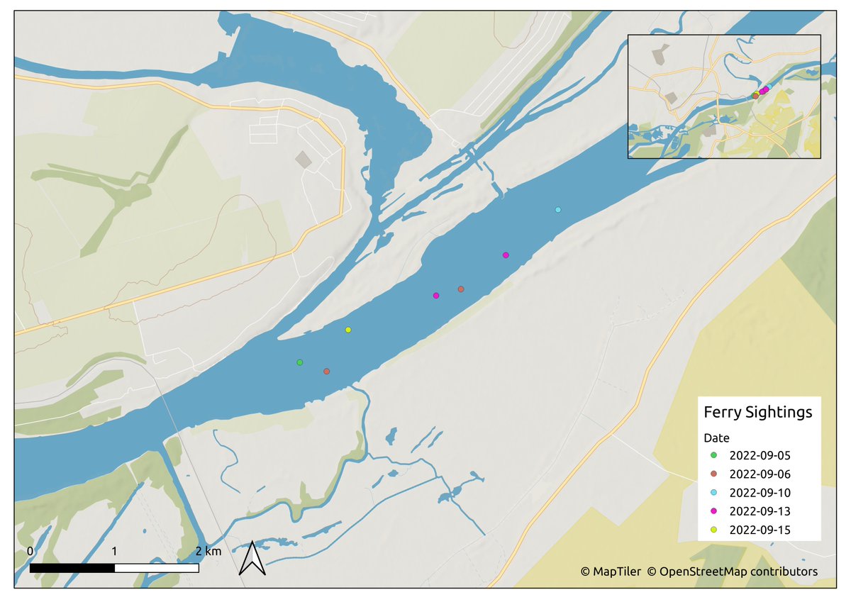
Looking back at radar and optical imagery since Sep 6 we can see many boats, some confirmed as pontoon ferries, operating east of the rail bridge near #Kherson. Here's a map with the locations plotted on different dates. Where does the ferry land? 🤔2/
For a little more context and pictures... 3/
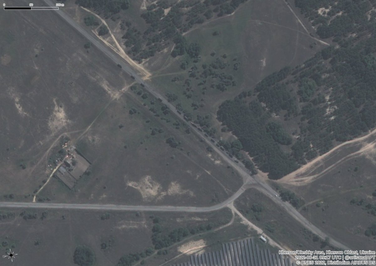
There has been increased activity on this road and beach at 46.6802 32.8015, based on the changing vehicle marks, that likely represents a Russian military ferry landing point after the other nearby point was recently attacked. This is just east of the r ail bridge in #Kherson 4/
Finding the landing point on the south shore has been harder. @Thor_UA suggested a point at 46.7109 32.9036. Unfortunately, after searching the shore line along here I can't find any ground changes that would suggest a landing point.😢 Any ideas? 5/

• • •

Missing some Tweet in this thread? You can try to force a refresh
 

Keep Current with Tim Ehrhart

Tim Ehrhart Profile picture

Stay in touch and get notified when new unrolls are available from this author!

Read all threads

This Thread may be Removed Anytime!

PDF

Twitter may remove this content at anytime! Save it as PDF for later use!

Try unrolling a thread yourself!

how to unroll video
  1. Follow @ThreadReaderApp to mention us!

  2. From a Twitter thread mention us with a keyword "unroll"
@threadreaderapp unroll

Practice here first or read more on our help page!

More from @ArtisanalAPT

Sep 2
Looking at imagery over #Kherson for 31 Aug we can see more Russian military vehicle movement than ever before. In this first image, we can see ~20 vehicles on the pontoon ferries transiting in each direction near 32.8035 46.6614.🧵 1/
11x Russian military vehicles waiting at 46.6442 32.8161 to move up the queue towards the military ferry across the #Dnipro 2/
16x Russian military vehicles queuing at 46.6287 32.8075. 3/
Read 6 tweets
Aug 29
Major movement of Russian equipment identified in 25 August 2022 imagery near #Kherson crossing the #Dnipro river. About 100 military vehicles seen moving in imagery, mostly northwards toward Kherson, at 08:48 UTC (11:48 Kyiv time) on 25 August. 1/ Image
At the edge of the image, we can see a convoy of at least 40 military vehicles waiting to move northward near the intersection at 46.6439 32.8159. 2/ Image
10 more Russian military vehicles wait at the military pontoon ferry landing point at 46.6614 32.8037 3/ Image
Read 9 tweets
Aug 24
After reviewing satellite photos from the past few weeks, I think @secretsqrl123 was right when he highlighted this location as the possible southern ferry point for the Russian military across the #Dnipro river. 1/
Imagery from 7 and 24 August show military vehicles near 46.660 32.804. Images from this month show military vehicles traveling along this dead-end road. This is likely the southern pontoon point for Russian military vehicles on the #Dnipro near #Kherson. 2/ ImageImage
The other end is 1.9 KM away at 46.6761 32.7902. This makes more sense than going further up the Konka river. 3/
Read 5 tweets
Aug 7
Imagery from 7 August confirms that there are at least *4* pontoon ferries active around Kherson in the #Dnipro and Konka rivers. All four were visible at the same time today. Some context. 🧵1/
Sentinel-2 imagery from 7 August over Kherson was clear and showed all four pontoons in different locations at the same time. 2 were in use at the #AntonovskiyBridge, as expected, and two more were hiding in the Konka river, as discussed previously. 2/
The first hiding spot in the Konka river is at about 46.659 32.796. Pontoons can be seen stored here in Sentinel 2 imagery on 28 July, 2 August, and 7 August. This area was previously noticed by @DefMon3 and confirmed 3/
Read 8 tweets
Aug 6
The possible pontoon loading area (46.631 32.756) near #Oleshky #Kherson (spotted by @DefMon3 & @OAlexanderDK) was empty during a satellite pass on Thursday. However, one small craft was captured moving up the #Konka river at 46.6378 32.7684. It's a busy place. Read on... 1/
Looking along the #Konka for the past week, I think there was another pontoon hidden to the east of the launch point in the marsh on 2022-08-02 at 46.6362 32.7709. It's SPOT imagery, so it's not super sharp, but it looks like a pontoon measuring about 60x12m and small boat. 2/
Here are three views of the same area of the marsh. It's pretty clear that something was there on Aug 2nd, but not Aug 4th or July 27th. Might be another area to watch to see if pontoons are stored here regularly. 3/
Read 8 tweets
Aug 3
Imagery from 1 August shows a Russian military ferry delivering 7 military vehicles near the rail bridge 5+ km upstream (46.6761 32.7902) of the known crossing point by the #AntonovskiyBridge by #Kherson. 3 vehicles appear ready to cross the other direction. 1/
Why are they moving military vehicles *here* instead of at the easier crossing point? What's the landing point on the south side of the river? There's no road directly across this point to support vehicles. 2/
One possibility is that they're ferrying them through the small Konka river to the highway by the city of #Oleshky. @DefMon3 and @OAlexanderDK highlighted a possible deployment point for the pontoons which was confirmed by 27 July imagery there. 3/
Read 5 tweets

Did Thread Reader help you today?

Support us! We are indie developers!


This site is made by just two indie developers on a laptop doing marketing, support and development! Read more about the story.

Become a Premium Member ($3/month or $30/year) and get exclusive features!

Become Premium

Don't want to be a Premium member but still want to support us?

Make a small donation by buying us coffee ($5) or help with server cost ($10)

Donate via Paypal

Or Donate anonymously using crypto!

Ethereum

0xfe58350B80634f60Fa6Dc149a72b4DFbc17D341E copy

Bitcoin

3ATGMxNzCUFzxpMCHL5sWSt4DVtS8UqXpi copy

Thank you for your support!

Follow Us on Twitter!

:(