Alastair Thompson Profile picture
Sep 29 12 tweets 7 min read
#ExtremeWeather #ClimateChangeNow

#HurricaneIAN Update thread.

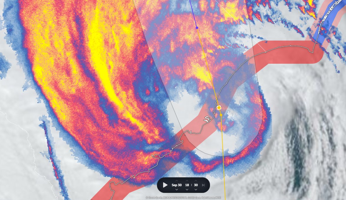
Near live 6hr satellite imagery #IAN beginning its exit of Florida over Cape Canaveral and the Kennedy Space Center. And it looks like it started strengthening significantly before it's center crossed the coast.
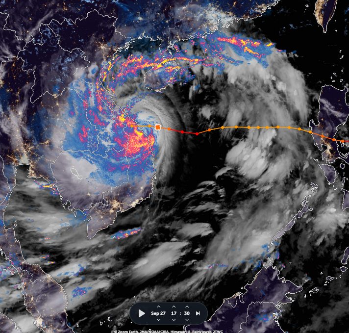
This wider angle view helps put the storm into wider perspective, in particular its size, and the importance and significance of the massive convective area to the East of Florida from which #TSIan #HurricaneIAN is being fuelled.
The big question now is how will #HurricaneIAN interact with this atmospheric river as it crosses the Atlantic heading towards the Carolinas, specifically, will this extremely complex moist air field strengthen or inhibit intensification.
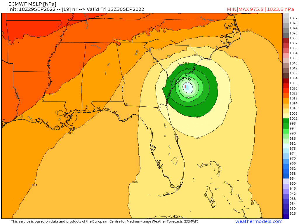
The NHC experts & the ECMWF and GFS numerical physics models, statistically very accurate over 2-3 days [Citation: @RyanMaue] agree. The transit is expected to take 3 days. So this is the probable path. ImageImage
However not behaving as expected is a feature with #HurricaneIAN. Also the proximity to land, slow speed, unusual size and track record of this big-wet-hurricane means it is not a certainty.
Then there is the unusual adjacent & colossal atmospheric river which #HurricaneIAN created which will bring heavy rain to Europe soon, starting in the UK and Ireland tomorrow. ImageImage
And the experimental short range HRRR model which did quite a good job of picking the correct exit point from Florida.
Either way we ought to know for sure pretty quickly.

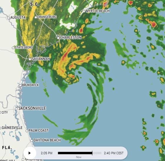
Right now the radar imagery suggests the exit angle from Florida is on the official track line.

But if #HurricaneIAN intensifies, slows down, speeds up, or heads more eastwards... there are other possibilities. ImageImageImage
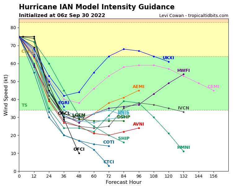
In this one - the EPS is the ECMWF ensemble, which the JTWC seems very fond of and is a very solid model you can see a bunch of ensemble members (in red) which show the storm strengthening.

However the cluster is vert tight and in agreement with the GFS ensemble. Image
This Florida radar loop shows a fairly large circulation seemingly working hard to close a circle.
And this clean satellite picture on sunrise this morning confirms that there is a fairly attempt being made by #HurricaneIAN to reorganise with astonishing bursts of convection all the way up the East Coast of Florida to Virgina.
And a wider view.

• • •

Missing some Tweet in this thread? You can try to force a refresh
 

Keep Current with Alastair Thompson

Alastair Thompson Profile picture

Stay in touch and get notified when new unrolls are available from this author!

Read all threads

This Thread may be Removed Anytime!

PDF

Twitter may remove this content at anytime! Save it as PDF for later use!

Try unrolling a thread yourself!

how to unroll video
  1. Follow @ThreadReaderApp to mention us!

  2. From a Twitter thread mention us with a keyword "unroll"
@threadreaderapp unroll

Practice here first or read more on our help page!

More from @althecat

Sep 30
I've been trying to figure out how best to visually explain how weird #HurricaneIAN is. This is the perfect illustration.

#HurricaneIAN will split in two, the Western part will head to the Virginias, for a while and then return to the Atlantic coast probably in Maryland.
#HurricaneIAN is a remarkable, and hopefully very unsuual phenomena, two distinct weather systems working together - that have appeared to be a single system for several days.

This, the final act, may be the most extraordinary part of this event. But not the most destructive. ImageImageImageImage
This CMISS animation shows what is happening vert clearly. And this explains a lot about #HurricaneIAN:
- its strength
- its super rapid intensification
- the persistent short range model forecast error
- its ability to remain intact over land
Read 5 tweets
Sep 30
This is what I was worried about the interaction between the atmospheric river and #HurricaneIAN.

The Wastern leading edge of the Atmospheric River is now pumping directly into #IAN and it appears to be strengthening over land. The Eyewall is not yet complete. Image
A closeup satelite view of what is likelu the center of #Hurricane IAN coming ashore at Charleston half an hour ago. Image
Read 7 tweets
Sep 30
What is happening in the Carolinas is not just a hurricane. The catastrophic event ahead is probably more due to the Atmospheric River which #HurricaneIAN has directed onshore. The second image here roughly delinates the two.

On the ground however this is one weather event. ImageImage
More on the #HurricaneIAN - Atmospheric River combination, to understand this event in context, this is a very important part of the story.

#ExtremeWeather #ClimateChangeNow.
This thread also looks at this issue. #HurricaneIAN has been embedded in this atmospheric river since it started intensifying explosively.

This combination is I think pretty unusual, and it may lead to unexpected consequences in the Carolinas.
Read 4 tweets
Sep 30
#HurricaneIAN update.

Four radar images over an hour 1-2pm UST.
#HurricaneIAN's motion is not as expected/forecast.

With sunrise approaching energy from the sun increases visibility of the circulation with the development of rain bands in the South Eastern quadrant. ImageImageImageImage
Spaghetti guidance is tightly clustered on Charleston landfall. After moving inland a very sharp turn W/SW is expected with some models even predicting a return back to the Carolina coast.

Tropical rain all the way to the Great Lakes is possible/likely given the size of Ian. ImageImageImage
Intensity guidance is very clear that the storm is expected to weaken - based on landfall today. This will change rapidly if Ian does not weaken or landfall quickly. Image
Read 15 tweets
Sep 30
The NHC's forecasting for #HurricaneIAN remains tricky. Inching closer to the North/South Carolina border. And from satellite data, it looks possible that the center of #HurricaneIan is east of the current line. ImageImage
The specialist HRRR model, which proved more accurate than the main models in predicting the path across Florida is now in agreement with ECMWF, GFS and NAM-CONUS on the location of landfall, but there is a broad range of intensity from 973-984 mb. ImageImageImageImage
There is also a 6 hour range in arrival time among the four models from 1pm to 7pm. Due to the size of the storm, the impacts of #HurricaneIAN on the Carolinas & beyond are already well and truly underway over night local time. Image
Read 12 tweets
Sep 29
This image shows why #HurricaneIAN was so strong. A Parallel line of supercells in an atmospheric river feeding of the hurricane, and in return providing a much larger area of Convection. And this is also the case with Super Typhoon Noru on the other side of the Pacific.
Interestingly #Noru's burst of intensification on approach to Vietnam coincided with part of the intensification period of #HurricaneIAN
Read 4 tweets

Did Thread Reader help you today?

Support us! We are indie developers!


This site is made by just two indie developers on a laptop doing marketing, support and development! Read more about the story.

Become a Premium Member ($3/month or $30/year) and get exclusive features!

Become Premium

Don't want to be a Premium member but still want to support us?

Make a small donation by buying us coffee ($5) or help with server cost ($10)

Donate via Paypal

Or Donate anonymously using crypto!

Ethereum

0xfe58350B80634f60Fa6Dc149a72b4DFbc17D341E copy

Bitcoin

3ATGMxNzCUFzxpMCHL5sWSt4DVtS8UqXpi copy

Thank you for your support!

Follow Us on Twitter!

:(