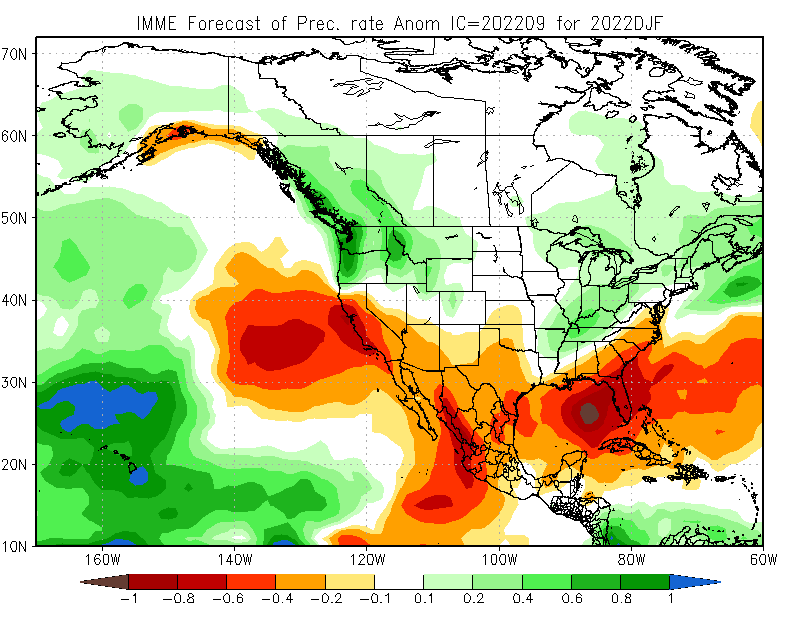
Latest seasonal predictions from NMME/IMME ensembles out today. Overall North Pacific pattern still looks very #LaNina-like: unusually wet PacNW and BC; unusually dry in SoCal & Lower Colorado Basin due to persistent NE Pacific ridging. HOWEVER... #WAwx#CAwx#AZwx (1/4)
...However, exact position of N. Pac. ridge is key. Too far east, & CA stays dry, but far enough west & Sierra benefits from cold storms diving south. High confidence in winter ridge, but CA will be on razor's edge--exact position will dictate dry vs wet overall. (2/4)#CAwx
This is why seasonal prediction is hard. It's quite likely models are correct about strong, anomalous North Pacific ridge signal (mainly due to #LaNina). But that doesn't directly translate to CA precip--it only offers a modest tilt in odds toward dry winter. #CAwx#CAwater (3/4)
BTW...I still think folks claiming that ENSO is "largely meaningless" for CA precip are...well, simply not correct. There's lots of geophysical evidence it does matter. But what is true is that predictive signal is modest, noisy, & conditional...which complicates prediction.(4/4)
Addendum: there are some very early hints that things might change rapidly by next spring: coupled ocean-atmosphere models are hinting at an eventual transition to El Nino conditions. It's still far too early to read too much into that, but...stay tuned.
Also, to the extent that atmosphere/ocean scientists view the coupled ENSO system as a kind of "damped spring oscillator," it would make sense to expect a (possibly large) swing in the opposite direction now that the system has been in a La Nina state for 3 consecutive years.
• • •
Missing some Tweet in this thread? You can try to
force a refresh
The coming week is shaping up to be a pretty crazy weather week in California, TBH--even more so than previously thought. Ongoing heatwave expected to be longer & peak even higher, & now we have potential influence of a soon-to develop hurricane to consider. (1/n) #CAwx#CAfire
First, exceptional daytime & nighttime heat (plus high humidity) continues across SoCal today. Some places may see all-time record warmest overnight temps today. In northern California, much drier heat is building,& temperatures will continue to rise further for days. (2/n) #CAwx
Interior Northern California is now heading for a truly dangerous, searing heatwave. All-time September records are now all but guaranteed in the Central Valley (on multiple consecutive days!), and all-time (any month) records now appear well within reach. #CAwx#CAfire
In this work, we develop a pair of plausible extreme, month-long winter storm sequences in California--one from the recent historical climate, and one from a much warmer future climate. These sequences involve a multi-week series of successive #AtmosphericRiver storms. (3/n)
We assess regional-scale atmospheric conditions favorable for dry lightning in central & northern California (N&C CA), as well as seasonality. We find that nearly half of all lightning strikes in N&C CA are "dry" (accompanied by <0.10 in. of rain). (2/n) iopscience.iop.org/article/10.108…
In some locations, including most of the San Francisco Bay Area, North Coast, and portions of Southern Sierra, fully 60-80% of May-Oct cloud-to-ground lightning strikes occur as dry lightning! Major implications for wildfire risk. (3/n) #CAwx#CAfireiopscience.iop.org/article/10.108…
Much of CA & NV has had a fairly mild start to summer--especially in the northern third of state, which even received some late-season precip and some locally below average temperatures over the past month or so. Well, that's all about to change across the interior... #CAwx
A huge ridge of high pressure will expand westward from its current position near center of continent (where it has been bringing record heat to Texas). This will bring an extremely broad region of hotter than usual temperatures to the entire western 2/3 of the country. #CAwx
While a persistent Four Corners ridge, plus hot temps, are typical for mid summer--this ridge will be significantly broader & stronger than usual even for mid-late July. By late July, much hotter than usual temperatures could extend from Pacific Coast to Great Plains! #CAwx
This was, by any quantitative measure, an extraordinary (and meteorologically extreme) lightning event across the southern half of California. But the societal impacts will be nowhere as severe as the dry lightning event in August 2020? Why? A brief thread: #CAwx#CAfire
First, & most importantly, the June 2022 thunderstorms were generally significantly wetter than the Aug 2020. Yesterday, most of these cells brought at least brief rains (and sometimes downpours). There were certainly dry strikes outside of rain cores, but most strikes were wet.
The June 2020, by contrast, were truly dry thunderstorms--many places only saw a trace of rainfall or nothing at all. Even a modest amount of rain co-occurring with lightning can greatly reduce (though not eliminate) the likelihood of a lightning-caused wildfire ignition.
Although I almost always keep my Tweets focused on weather, climate change, and related Earth system events, this thread is going to be a little more personal. May is #EhlersDanlosAwarenessMonth...and I have Ehlers Danlos Syndrome (hypermobility type). #hEDS (1/41)
Before continuing, I want to emphasize that I'm #NotThatKindofDoctor--I'm a physical scientist & science communicator, not a biomedical scientist nor a medical doctor. All the information and reflections in this thread are therefore either personal reflections... (2/41)
...or come from the perspective of a "highly informed patient." I do, however, strive to get the facts right, and offer links to various true experts in the clinical and research fields below. (3/41)