[Ongoing coverage #HurricaneJulia Event #ExtremeWeather #ClimateChangeNow]

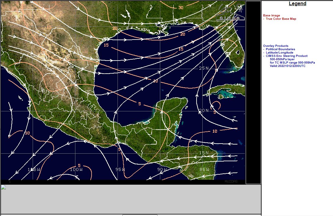
At sunrise the remnants of #HurricaneJulia now #Invest93L are developing extremely rapidly over the South Western Gulf of Mexico.
And the southern #Invest93L remnants of #HurricaneJulia are also developing very rapidly.
Moreover, because of their proximity and positioning the southern storm's outflows are feeding #Invest93L North, which help may explain its spectacular burst of convection on daybreak.
This connection may gradually weaken however as the southern storm is more able to move NW than the northern storm which is experiencing very strong opposing NE shear.
New #Invest93L guidance now includes two tracks heading north.

• • •

Missing some Tweet in this thread? You can try to force a refresh
 

Keep Current with Alastair Thompson

Alastair Thompson Profile picture

Stay in touch and get notified when new unrolls are available from this author!

Read all threads

This Thread may be Removed Anytime!

PDF

Twitter may remove this content at anytime! Save it as PDF for later use!

Try unrolling a thread yourself!

how to unroll video
  1. Follow @ThreadReaderApp to mention us!

  2. From a Twitter thread mention us with a keyword "unroll"
@threadreaderapp unroll

Practice here first or read more on our help page!

More from @althecat

Oct 13
#CentralAmerica #ExtremeWeather update thread.

Sunrise over #Karl is imminent. Its going to be another interesting day I think. Image
Image
1. Sunrise on Karl, it may be a trick of the early light but I can see a larger low level circulation that fully surrounds the 2nd larger part of Karl.

2. The second image says where we are supposed to be now in the model timeline and it certainly looks about right. ImageImage
Read 19 tweets
Oct 13
[#NotYetAHurricaneKarl update Thread, waiting for sunrise ed. #ExtremeWeather #ClimateChangeNow ]

The ridge to the north of #Karl has moved south a fair bit and appears to be pushing #Karl to the south at the eastern edge of the offical NHC Track cone.
Here's another view where you can see the leading edge of the ridge that is pushing down on the hurricane capturing it near the entrance to the Tucanpecer's northern funnel.
Lookingclose at the last four hours @NHC_Atlantic may have a point about #NotYetAHurricane #Karl not quite yet being a hurricane - as predicted by the GFS it has collapsed and broadened out close to midnight as the models said.
Read 29 tweets
Oct 13
And now, finally, @NHC_Atlantic has put up a new advisory on #TSKarl #HurricaneKarl

...AIR FORCE RESERVE HURRICANE HUNTERS INVESTIGATING KARL... Image
Current satellite imagery shows why NHC thinks Karl will also be pushed through the Tehuantepecer wind gap for a 2nd time - its all a matter of timing. Karl is already clearly outside their cone, the railway lines show where a ridge is building as dry air pushes south. ImageImage
You can see the scenario in the latest GFS model here. But bear in mind that this is based on the assumption that Karl is still a tropical storm. And as you can see it is expected to decay very rapidly over night.
Read 8 tweets
Oct 12
Its now pretty clear what is going on. #HurricaneKarl #TSKarl is caught in an atmospheric river generated by #TD99E (in a similar way to how #HurricaneIan was) and headed towards florida - not Mexico.
The second overlay is a special "steering" product that allows you to see where a cyclone is headed - it focusses on the 500-850hpa wind range (1.5 to 5.5kms high winds ) which are particularly important for pushing cyclones. Image
And as you can see #HurricaneKarl is being steered towards northern Florida at present.
Read 6 tweets
Oct 12
This IR satelllite image [src: @TropicalTidbits] shows #TSKarl is unquestionably now #HurricaneKarl. It also shows it is not moving towards the Mexico coast line as per the current @NHC_Atlantic forecast - but moving NE. And the transformation into this was 3 hours ago.
Here are its first three hours as a hurricane.
And this is the most recent @NHC_Atlantic discussion bulletin for #TSKarl, issued 2 hours ago. ImageImage
Read 13 tweets
Oct 12
Image
These storms which are forming over Cuba and Haiti are 1200 to 2000kms away from #KARL but it is clear that the cause is #TSKarl, which still has not been designated as a hurricane even though its convection field now covers 454,000 kms.
Read 8 tweets

Did Thread Reader help you today?

Support us! We are indie developers!


This site is made by just two indie developers on a laptop doing marketing, support and development! Read more about the story.

Become a Premium Member ($3/month or $30/year) and get exclusive features!

Become Premium

Don't want to be a Premium member but still want to support us?

Make a small donation by buying us coffee ($5) or help with server cost ($10)

Donate via Paypal

Or Donate anonymously using crypto!

Ethereum

0xfe58350B80634f60Fa6Dc149a72b4DFbc17D341E copy

Bitcoin

3ATGMxNzCUFzxpMCHL5sWSt4DVtS8UqXpi copy

Thank you for your support!

Follow Us on Twitter!

:(