#CentralAmerica #ExtremeWeather update thread.
Sunrise over #Karl is imminent. Its going to be another interesting day I think.
Sunrise over #Karl is imminent. Its going to be another interesting day I think.
https://twitter.com/althecat/status/1580317553855197184


1. Sunrise on Karl, it may be a trick of the early light but I can see a larger low level circulation that fully surrounds the 2nd larger part of Karl.
2. The second image says where we are supposed to be now in the model timeline and it certainly looks about right.
2. The second image says where we are supposed to be now in the model timeline and it certainly looks about right.


Visible high resolution image via @TropicalTidbits

Satellite animation first light zoomed in on the two storms.
A view of the north western quadrant and the squall line coming in over the sea associated with the arrival of an arctic blast.
.@zoom_earth view of the same approaching interaction
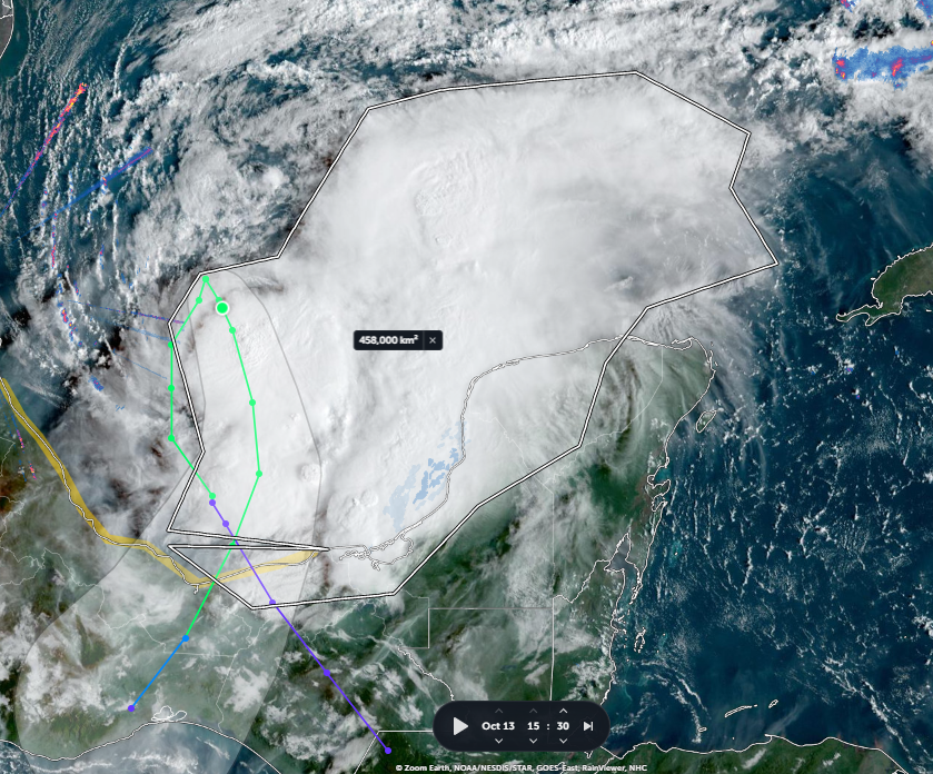
And a close up on #TSKarl at sunrise.
At 458,000km2 of overall sunrise convection & adjacent cloud and 187,000 km2 of intense sunsrise convection the 2 parts of #KARL are certainly starting stronger this morning than yesterday.

This animation is 4 hours and started at 7am local time so well before sunrise. At first glance it looks like the northern part of the RH arm of Karl is already being effected by west-east shear.
On the LFS there is clearly aspinning vortex there, albeit with little structure.
On the LFS there is clearly aspinning vortex there, albeit with little structure.
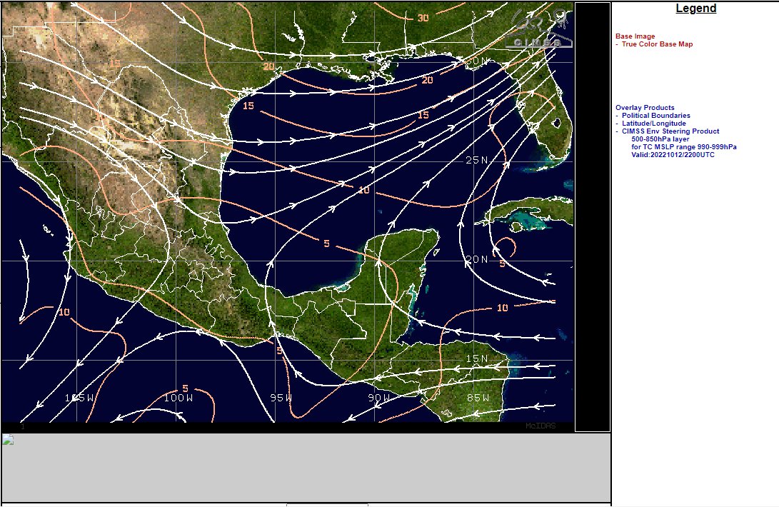
Here is what is forecast to happen to this storm over the next 117 hours. This is the 13:06Z GFS model run for Precipitable water, which is mostly what this event is all about - that and the Tehuantepec wind gap #TSKarl #Karl is expected cross around midnight tonight.
However according to the forecast that is far from the end of this as far as Mexico is concerned. Several more Tehuantepec wind gap events are forecast after #Karl gets squelched over the following 200 hours.
Looks like inter-ocean ping pong with storms accross the Tehuantepec gap - with a high probability of more hurricanes.
There is a real forecast possibility of two more before the 18th, which could raise Central America's Hurricane count to 4 in 10 days.
There is a real forecast possibility of two more before the 18th, which could raise Central America's Hurricane count to 4 in 10 days.
Which is why I am so interested in what happens to #Karl.
When the remnants of #Julia went through the gap the storm became two - #Karl & #Invest99E. This sort of thing could conceivably continue beyond next Tuesday.
Current 29/10 Forecast:
When the remnants of #Julia went through the gap the storm became two - #Karl & #Invest99E. This sort of thing could conceivably continue beyond next Tuesday.
Current 29/10 Forecast:

It would perhaps be farcical if it weren't also killing people, and destroying property and infrastructure.
The 2nd cause to this event is this >>
Animation: Unusual atmospheric conditions in North America delivering an endless series of arctic wind blasts.
The 2nd cause to this event is this >>
Animation: Unusual atmospheric conditions in North America delivering an endless series of arctic wind blasts.
Its almost like north America has been occupied by a weather hydra that hates hurricanes. The endless series of arctic blasts are also preventing water from escaping the Carribean and Gulf via the usual route up the Eastern Seaboard.
In monitoring this I am hoping to see #Karl get away to the East and restore a normal weather system. Pakistan had 20 straight days of aberrant torrential rain and it was the catastrophe of the year. It would be terrible for Central America if something similar happened again.
This explanation is partly for #NHC_Atlantic's forecasters who may by now be wondering why a journalist is constantly second guessing their cyclone warnings.
That's me for this thread - I will be back later to see what has happened.
Ciao.
/ends
@threadreaderapp unroll
Ciao.
/ends
@threadreaderapp unroll
• • •
Missing some Tweet in this thread? You can try to
force a refresh