🥳Free one hour mapping tutorial, tomorrow Thur 3 Nov at 13:00 UK time* (9am EST, 14:00 CET, 16:00 Istanbul, (00:00 Sydney, sorry)) - all welcome🥳

See image Alt text for description and Zoom link

#30daymapchallenge An invitation to attend a o...
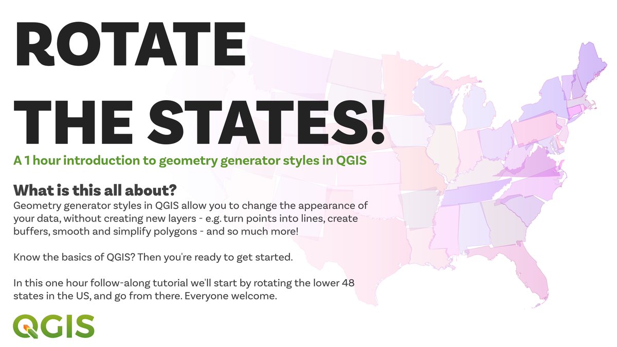
this is a bit of an experiment that I have been planning to do for a while so let's see how it goes - so long as you know the basics of QGIS you should learn some useful new stuff for design, and possibly more
I'll share lots of practical learning things in this short session, as well as styling tips for how to do all sorts of interesting design/effect things
the point is to learn about geometry generator expressions though play here, using the lower 48 US states as an example - I may do another one in future, depending on how this one goes
there are tons of practical applications for these techniques in QGIS, but you can also do interesting design stuff - so see top of this thread if you want to join this 1hr session today, at 13:00 UK time

(also happens to coincide with #30DayMapChallenge day on polygons)

• • •

Missing some Tweet in this thread? You can try to force a refresh
 

Keep Current with Alasdair Rae

Alasdair Rae Profile picture

Stay in touch and get notified when new unrolls are available from this author!

Read all threads

This Thread may be Removed Anytime!

PDF

Twitter may remove this content at anytime! Save it as PDF for later use!

Try unrolling a thread yourself!

how to unroll video
  1. Follow @ThreadReaderApp to mention us!

  2. From a Twitter thread mention us with a keyword "unroll"
@threadreaderapp unroll

Practice here first or read more on our help page!

More from @undertheraedar

Oct 27
Reading the excellent @JonnElledge substack yesterday and obviously skipped straight to the 'measuring city size', featuring the addictive @thomasforth population around a point tool, and it got me thinking...

jonn.substack.com
what do you get if you extend the distance to 100km around a point (e.g. as a very rough proxy for longer post-Covid commute zones) and do it systematically every 5km across the whole UK?
taking a quarter of the UK population (approx 17 million) as a benchmark, how many of the evenly spaced 5km points have more than a quarter of the UK population within 100km?

This is what you get when you run that query
Read 10 tweets
Oct 24
Big news from the UK today that I am truly excited about. Finally got my hands on the new book from the brilliant @theboysmithy - beautiful, super-interesting and a really enjoyable read. Image
I actually saw a full manuscript before the print version came out so my pristine paper copy is now about to be thoroughly thumbed
and seeing as how height is a topic of conversation today (and always), Chapter 14 gets us right up to speed on this too Image
Read 5 tweets
Oct 8
What do the highlighted constituencies have in common?

Answer will appear below when someone gets it (or when I post it) but consider yourself a fully certified map twitter expert if you already know it. Image
lots of answers that could potentially also be correct - and which demonstrate next-level nerdery - but whoever goes forth with the true answer will surely be crowned twitter map champion forever Mystery map - yes, there wa...
apologies for the torture, didn't quite realise pain this might cause - possibly think a little more low-brow than some of the answers
Read 7 tweets
Oct 7
Map of the day is a very comet-style UK general election 2019 map experiment, where

- colour of dot = winning party
- comet trail colour = second place
- comet train length = how far behind second place was

(dot is just a coloured centroid, see Alt text for QGIS geom gen code) Apply the following geometry generator code to the uk electi
also possibly interesting but also possibly meaningless is the line on this 'who came second in 2019' map
always a bit of this with these kinds of map experiments but interesting to see what I see vs what other see
Read 5 tweets
Sep 26
🚨Big new batch of local GIS open data resources 🚨 for Great Britain - based on OS and ONS open data - a shortish thread (data for all local authorities individually, as well as full Great Britain files, all in one place - see screenshot at link below)

automaticknowledge.org/gb/ ImageImageImage
there's buildings, greenspace, places, rail (stations + lines), roads, water - all for single local authorities, or for full Great Britain, if you need it - and simple file names so you can tell what's what - e.g. here's the buildings folder

automaticknowledge.org/gb/buildings/ Image
we also patched together 2,859 individual terrain tiles and then compressed them into one big (but fairly low file size), georeferenced tif that can be used to create hillshades/used as a backdrop layer, etc

automaticknowledge.org/gb/terrain/ ImageImageImage
Read 21 tweets
Sep 25
A little bit of Highland map therapy this weekend, in 8 steps
probably enjoy this more than watching the news, it has to be said ImageImageImageImage
now just need to decide between where to go next, haven't been to Scrabster or Wick for a loooooong time ImageImageImageImage
Read 4 tweets

Did Thread Reader help you today?

Support us! We are indie developers!


This site is made by just two indie developers on a laptop doing marketing, support and development! Read more about the story.

Become a Premium Member ($3/month or $30/year) and get exclusive features!

Become Premium

Don't want to be a Premium member but still want to support us?

Make a small donation by buying us coffee ($5) or help with server cost ($10)

Donate via Paypal

Or Donate anonymously using crypto!

Ethereum

0xfe58350B80634f60Fa6Dc149a72b4DFbc17D341E copy

Bitcoin

3ATGMxNzCUFzxpMCHL5sWSt4DVtS8UqXpi copy

Thank you for your support!

Follow Us on Twitter!

:(