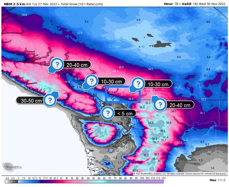
Snowstorm synopsis. A strong NW jet will intensify a surface low late Tuesday into Wednesday AM. Not a typical weak inside slider low as pressure deepens to ~985 hPa on approach to N. Vancouver Island.
Periods of snow intensify across VI later Tuesday afternoon, with mostly dry conditions across the Lower Mainland. There's a chance the snow is fashionably late.
Wind gusts close to 90 km/h are possible across exposed portions of the Strait of Georgia & S. Van Island Tuesday night. Expect some power outages with gusty winds and heavy wet snow clogging trees and powerlines.
Snow thumps Tuesday overnight, changing to wintry-mix/rain along the straits & mainly rain in Greater Victoria. Total mess Wednesday AM, including school cancellations & major transportation issues.
Crude snowfall projections, but locally 20+ cm of snow, the snowiest November day since 2006. The highest snowfall uncertainty lies south of the Fraser. #BCSnow#BCStorm
• • •
Missing some Tweet in this thread? You can try to
force a refresh
To find the direct link between climate change & an extreme event is a frivolous one. The Fraser Valley is a flood-prone region, as floods have occurred in the past. This one carved a unique path deep into the Fraser Canyon, the worst place for a stalling atmospheric river. (1/7)
The catastrophic atmospheric river had deep tropical roots. That is where sea-surface temperatures are well above average. A warmer atmosphere and warmer sea surface temperature can hold more water vapour, making climate change a culprit here. (2/7)
B.C.’s Interior is littered with burn scars from the horrific wildfire season of 2021. The town of Merritt and Princeton both experienced severe flooding; consequently, enhanced by the charred land; water runs off the new water-repellent compounds left after a wildfire. (3/7)
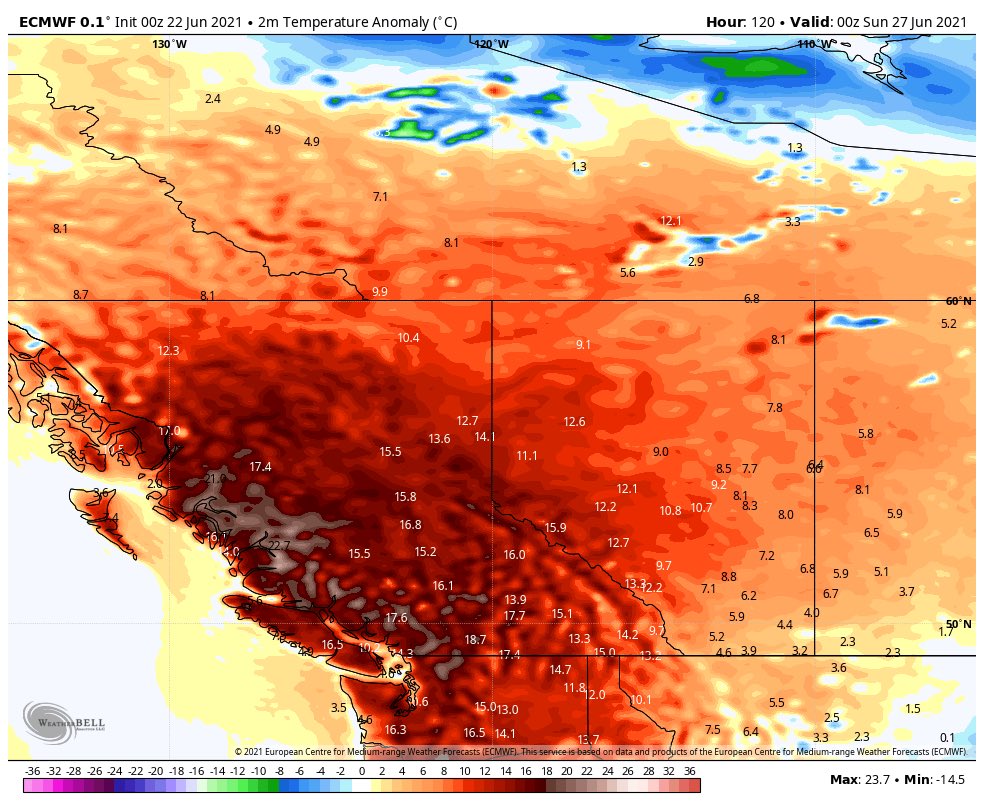
Climate change has its fingerprints all over this unprecedented heat event. The extremes of the atmosphere are being re-written before our very eyes this weekend and beyond. (1/7)
Climate change increases the frequency and intensity of heat waves. An easy way to think about it is that the temperatures in this current heatwave are a couple of degrees higher because of anthropogenic climate change. (2/7)
You look at the weather charts, and the cause is simple - a massive upper ridge in the jet stream has built to an unprecedented level. The jet stream is doing its thing, acting like a giant skipping rope rounding the planet, attempting to re-balance heat. (3/7)
Absolutely absurd temperatures forecast, afraid some all-time temperature records are in jeopardy in British Columbia and Pacific Northwest. City emergency management officials: time to enact the extreme heat procedures and plans. Cooling centres, check on vulnerable etc. #BCHeat
This part of the world isn’t accustomed to these temperatures: take Abbotsford as an example, perhaps 3 consecutive days at or above all-time readings.
Unfortunately it’s going to be extraordinarily humid - a rarity for the South Coast. All time humidex records possible feeling near 40 even for some coastal communities #BCHeat