2023 is bringing us an #AtmosphericRiver for its arrival! Because 280 characters is never enough to summarize these, here's another 🧵of our updates and what we're expecting! #CAwx (1/6)
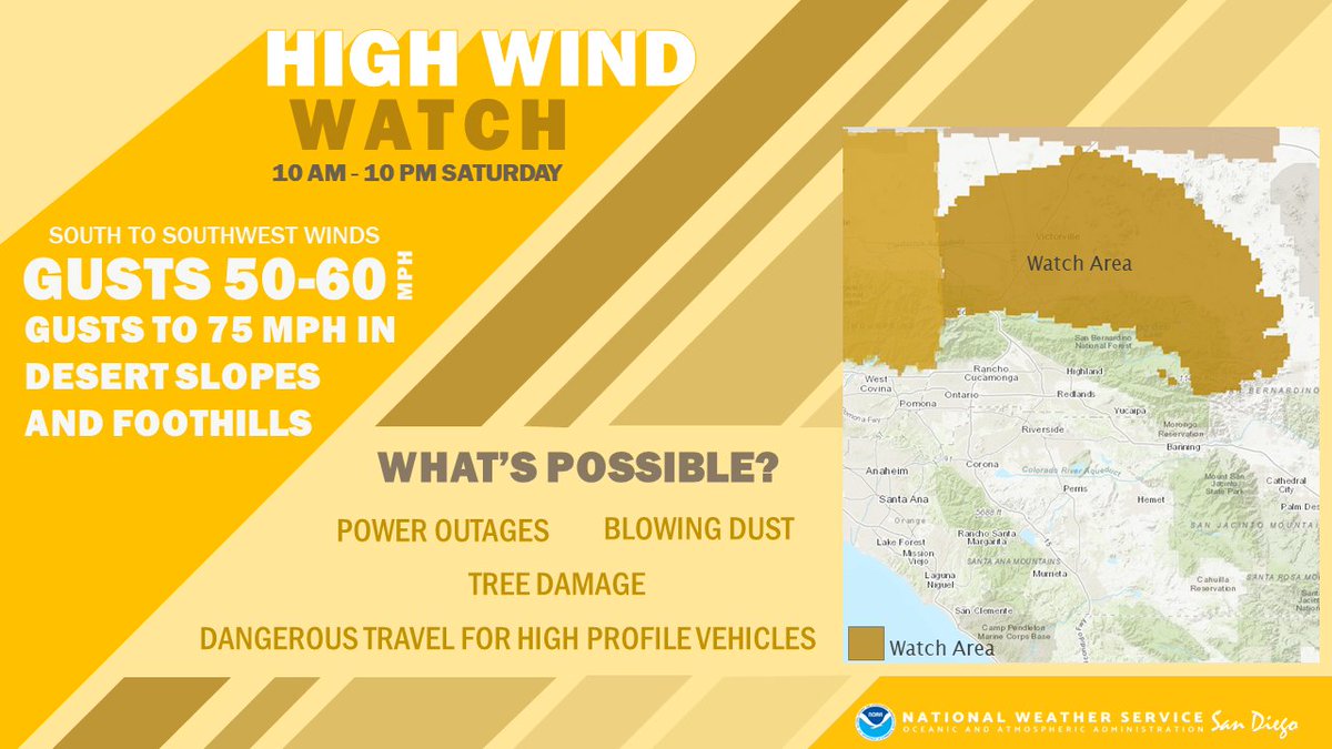
We've hoisted a Flood Watch for tomorrow evening given the potential for widespread rainfall everywhere from the mountains westward. Use extra caution if you're out and about! Travel will be dangerous given rain, lots of folks on the road, and... other reasons🥴#IYKYK #CAwx (2/6) A graphic of rainfall total...A Flood Watch has been issu...
It'll also be windy during the daytime on Saturday, the kinda wind that likes to transport trash cans, unsecured holiday decor, and other loose objects. Use caution if traveling in a high-profile vehicle as well. #CAwx (3/6) A graphic of peak wind gust...A High Wind Watch is in eff...
Snow levels still look pretty high, with most mountain communities only receiving around 1 inch of snow and heavier amounts on the peaks. #CAwx (4/6) A graphic of snowfall for S...
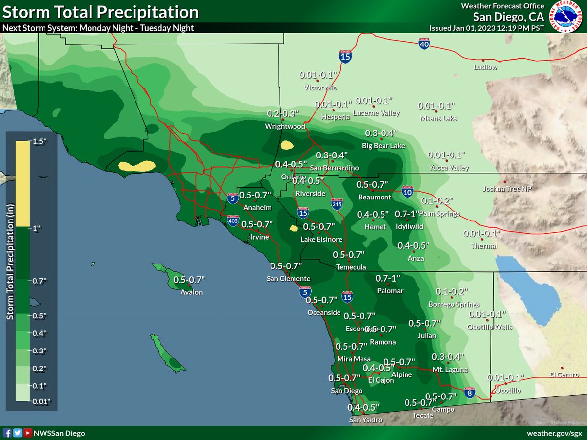
The unsettled and stormy pattern looks to hang on through next week! Here are precipitation chances for Tuesday and Thursday of next week. We'll have more on these systems as we approach their arrival next week. #CAwx (5/6) A graphic showing precipita...A graphic showing precipita...
We hope everyone has a very safe and Happy New Year's Eve and Day! Stay tuned to our pages for updates. #CAwx (6/6)

• • •

Missing some Tweet in this thread? You can try to force a refresh
 

Keep Current with NWS San Diego

NWS San Diego Profile picture

Stay in touch and get notified when new unrolls are available from this author!

Read all threads

This Thread may be Removed Anytime!

PDF

Twitter may remove this content at anytime! Save it as PDF for later use!

Try unrolling a thread yourself!

how to unroll video
  1. Follow @ThreadReaderApp to mention us!

  2. From a Twitter thread mention us with a keyword "unroll"
@threadreaderapp unroll

Practice here first or read more on our help page!

More from @NWSSanDiego

Jan 1
(1/4) The first week of 2023 looks quite stormy! After rain diminishes tonight, the next chance for widespread rain looks to develop tomorrow night-Tue morning. The rain isn't expected to be as heavy as last night, but widespread accumulations are expected. Hazardous Weather Outlook A...
(2/4) Rain will increase from northwest to southeast Monday night. Preliminary rain totals are as follows:
Coast: 0.50-0.75"
Valleys: 0.40-0.75"
Mountains: 0.50-1.00"
Deserts: 0.01-0.20" Chance of Precipitation: Mo...Preliminary rain totals are...
(3/4) Another, and potentially significant storm system, looks to move into Southern California late this week. Rain amounts are uncertain at this time, but could be significant. Tune in over the next few days as we refine the forecast!
#CAwx Chance of Precipitation: Mo...
Read 4 tweets

Did Thread Reader help you today?

Support us! We are indie developers!


This site is made by just two indie developers on a laptop doing marketing, support and development! Read more about the story.

Become a Premium Member ($3/month or $30/year) and get exclusive features!

Become Premium

Don't want to be a Premium member but still want to support us?

Make a small donation by buying us coffee ($5) or help with server cost ($10)

Donate via Paypal

Or Donate anonymously using crypto!

Ethereum

0xfe58350B80634f60Fa6Dc149a72b4DFbc17D341E copy

Bitcoin

3ATGMxNzCUFzxpMCHL5sWSt4DVtS8UqXpi copy

Thank you for your support!

Follow Us on Twitter!

:(