(1/4) ⚠️ HAZARDOUS TRAVEL IN THE MOUNTAINS THIS WEEK ⚠️ winds will rapidly increase this evening and peak overnight in the mountains. Snow levels will crash tomorrow morning, potentially as low as 2000 feet. READ THE WHOLE TWEET THREAD BELOW:
(2/4) PLEASE NOTE: The snow accumulation graphic is only for snow accumulations through Thursday morning. ADDITIONAL HEAVY SNOW, ON THE ORDER OF SEVERAL FEET OF SNOW, WILL BE POSSIBLE THURSDAY NIGHT THROUGH SATURDAY.
(3/4) Winter Weather Advisories have been issued for LOCATIONS ABOVE 2500 FEET in the Inland Empire, and for LOCATIONS ABOVE 2000 FEET in the San Diego County Valleys through Thursday morning. Winter Storm Warnings are in effect for the mountains through Saturday.
(4/4) Travel could become difficult to nearly impossible, especially tonight through Wednesday due to the strong winds, and again Thursday night through Saturday due to SEVERAL FEET OF SNOW ACCUMULATIONS. #CAwx
• • •
Missing some Tweet in this thread? You can try to
force a refresh
(1/4) Here is our preliminary thoughts on the timing and intensity of the precipitation for the rest of this week. Off-and-on rain showers will be possible from late tonight through Thursday with light accumulations. Heavier and more widespread precip develops Thursday afternoon.
(2/4) For Thursday through Saturday, an atmospheric river takes aim at Southern California, leading to widespread moderate to heavy rain, with the heaviest expected to occur on Friday. Heavy mountain snow will also be possible Thu-Sat, generally above 5000 feet.
(3/4) Here are our preliminary forecasted rain totals through Saturday. We are always looking at new model data, ingesting our new thoughts into the forecast & using our experience to adjust the forecast as the event approaches. Things change, resulting in updates to a forecast.
(1/3) In preparation for the hazardous conditions developing this week, we will be sharing safety information for the multiple hazards we are expecting. Up first, winter weather (snow) safety! ❄️☃️
(2/3) There is a Winter Storm Warning in effect from tonight through Saturday for the San Bernardino/ Riverside/ San Diego County Mountains, Santa Ana Mountains. Expect damaging winds and extremely heavy snowfall.
(3/3) In addition, snow levels will be very low, with impacts possible 2000+ ft in the Inland Empire & 2500+ ft in the San Diego County Valleys. Travel will be hazardous due to snow showers combined with strong winds. A Winter Weather Advisory is in effect from Wed AM-Thu AM.
(1/8) We have quite the storm this week. We will lay out the impacts in this order: 1. Rain and Flooding 2. Wind 3. Snow 4. Hazardous Marine Conditions
Please read through the full thread & know that we are always looking at/updating the forecast as we get new information. #CAwx
(2/8) Scattered showers will be possible as early as Mon morning across northern areas & will spread to the southeast by Mon night. The heaviest/most widespread rain will occur Tue morning/afternoon, and flooding will be possible. T-storms will also be possible during this time.
A ⚠️ FLOOD WATCH ⚠️ has been issued for our northern areas, where the heaviest rain/highest rain rates are expected. Thunderstorms will be possible on Tuesday; rain rates may exceed 1"/hr with the heaviest cells. There will be a HIGH risk for flooding near recent burn scars.
(1/5) After a quiet weekend weather-wise, the next in a series of storm systems will begin to impact SoCal next week. Widespread moderate to heavy rain (with a slight chance of t-storms) and very strong winds can be anticipated. The heaviest precip is expected across SBCo Mtns.
(2/5) Rain may develop as early as Mon morning across Orange/San Bernardino Counties, with light rain spreading southeastward through the day. However, an increase in activity is expected through Monday night, with with heaviest and most widespread rain occurring on Tuesday.
(3/5) The @NWSWPC is outlooking a SLIGHT RISK for excessive rain leading to flash flooding across portions of Orange, San Bernardino and Riverside Counties. Rain rates could be very high in the strongest cells, so remain alert for flooding.
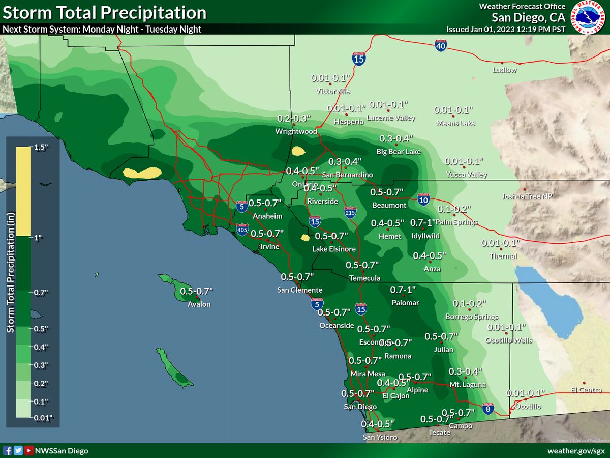
(1/4) The first week of 2023 looks quite stormy! After rain diminishes tonight, the next chance for widespread rain looks to develop tomorrow night-Tue morning. The rain isn't expected to be as heavy as last night, but widespread accumulations are expected.
(2/4) Rain will increase from northwest to southeast Monday night. Preliminary rain totals are as follows:
Coast: 0.50-0.75"
Valleys: 0.40-0.75"
Mountains: 0.50-1.00"
Deserts: 0.01-0.20"
(3/4) Another, and potentially significant storm system, looks to move into Southern California late this week. Rain amounts are uncertain at this time, but could be significant. Tune in over the next few days as we refine the forecast! #CAwx
2023 is bringing us an #AtmosphericRiver for its arrival! Because 280 characters is never enough to summarize these, here's another 🧵of our updates and what we're expecting! #CAwx (1/6)
We've hoisted a Flood Watch for tomorrow evening given the potential for widespread rainfall everywhere from the mountains westward. Use extra caution if you're out and about! Travel will be dangerous given rain, lots of folks on the road, and... other reasons🥴#IYKYK#CAwx (2/6)
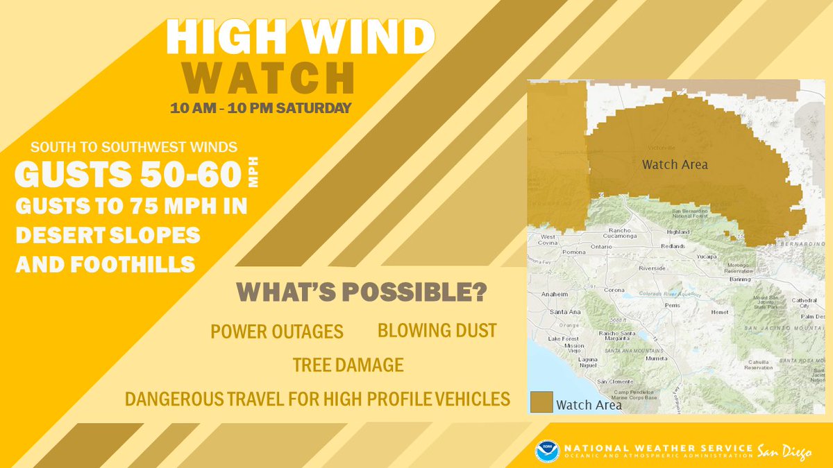
It'll also be windy during the daytime on Saturday, the kinda wind that likes to transport trash cans, unsecured holiday decor, and other loose objects. Use caution if traveling in a high-profile vehicle as well. #CAwx (3/6)