The @OhioEPA should comment on this ASAP.

#EastPalestine OH is one of the most vulnerable areas of the county for Ground Water Pollution Potential.

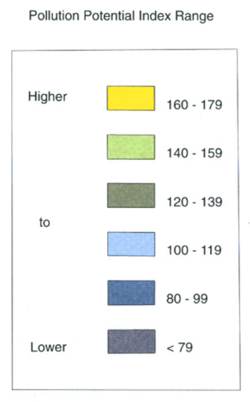
Short version: yellow on map means you are MORE susceptible to ground water pollution from surface sources. Source: Ohio DNR
#EastPalestine is YELLOW bigly. That means VERY susceptible to ground water pollution.

TRUST THE SCIENCE Original document here 👇:
ohiodnr.gov/static/documen…

This conclusion was derived using the D.R.A.S.T.I.C. method which accounts for:
But the EPA gonna gaslight you like you're a dumb person.
The map you see is a Pollution Potential Map.
and DRASTIC helps calculate who / where is at the highest risk, greater potential for ground water pollution.
Here is the full resolution of the Columbiana County Ground Water Pollution Potential map. If you're yellow, you have a high risk of ground water pollution potential.
EPA says the pump inlets are 56-98 feet below surface. That dont matter cuz the WATER table is only 15-18 feet below surface at the well site.

Their statements are not truthful. Here's the US Geo water table history for the #EastPalestineOH city wells:
Here are the city wells. 0.33 miles from the polluted Sulphur run. And 18 feet from the surface to the water table.
So what do you/they do?

You:
(1) monitor your potable water.
(2) monitor your basement air.
(3) don't go near the creeks.

They (will probably):
(1) monitor ground wells
(2) drill new water wells far away
(3) create a water demand to consume the contaminated water
I am just a dumb guy on the internet. Please do your own research. I am not a scientist, geologist, etc. But this seems very straight forward IMO.

I encourage smart people to refute this.
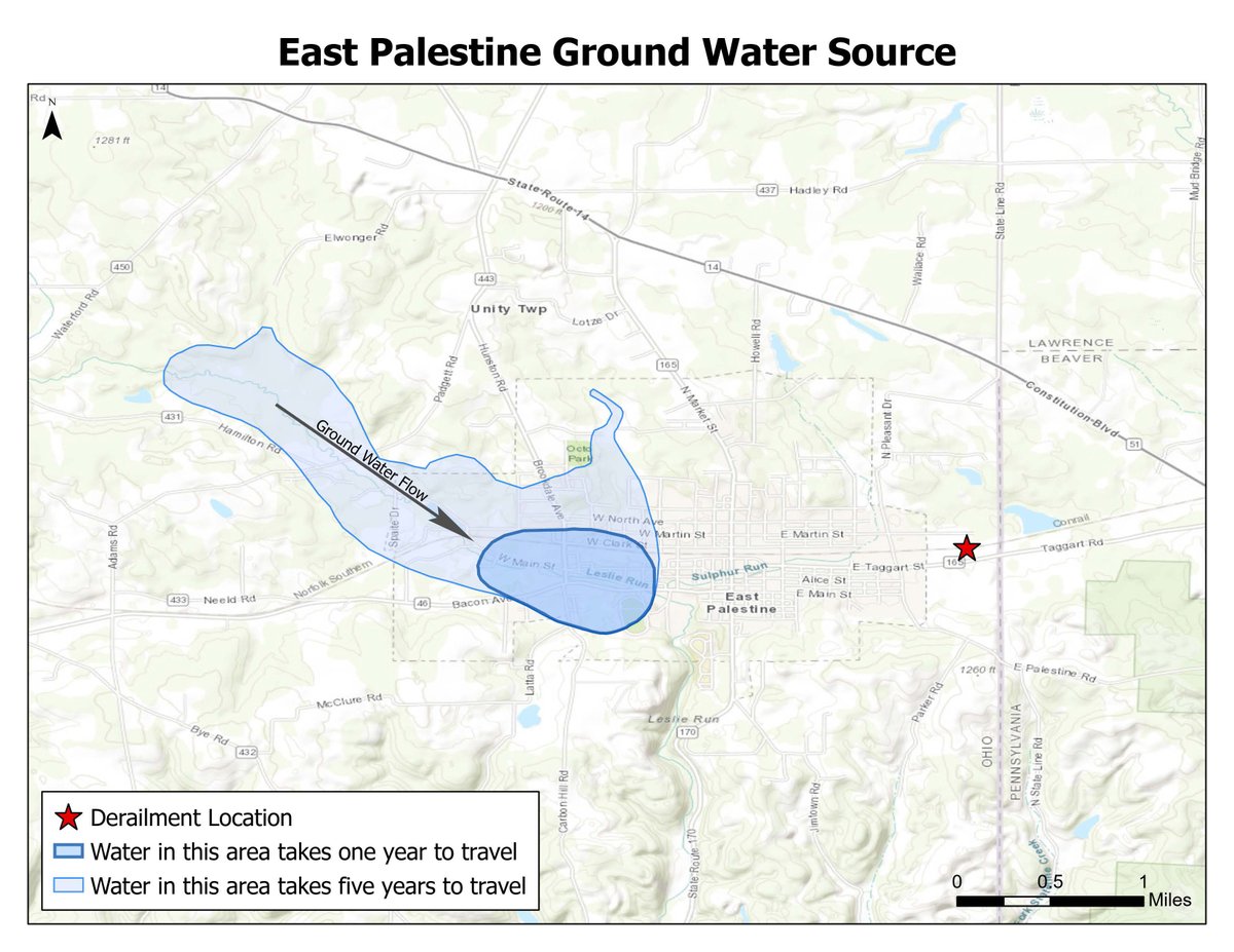
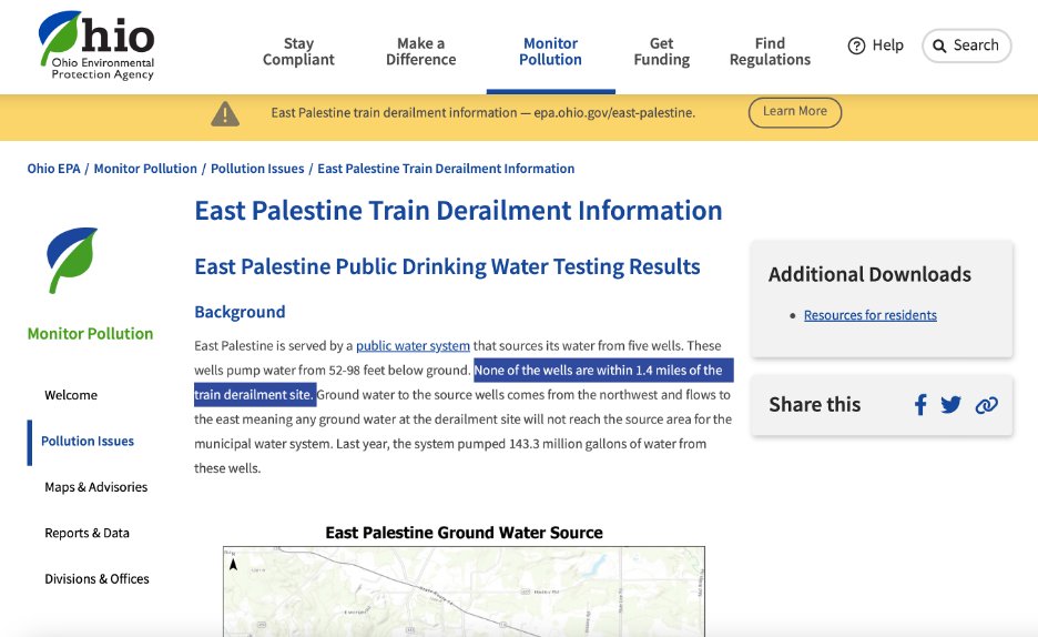
Another tweet. The @OhioEPA says "...any ground water at the derailment site will not reach the source area for the municipal water system"

Removing 143.3 millions of gallons through pumps wont pull water from the East?

Only the West? GTFOH. Show me a computer model. I call BS
If you made it this far I will give you a follow lol.
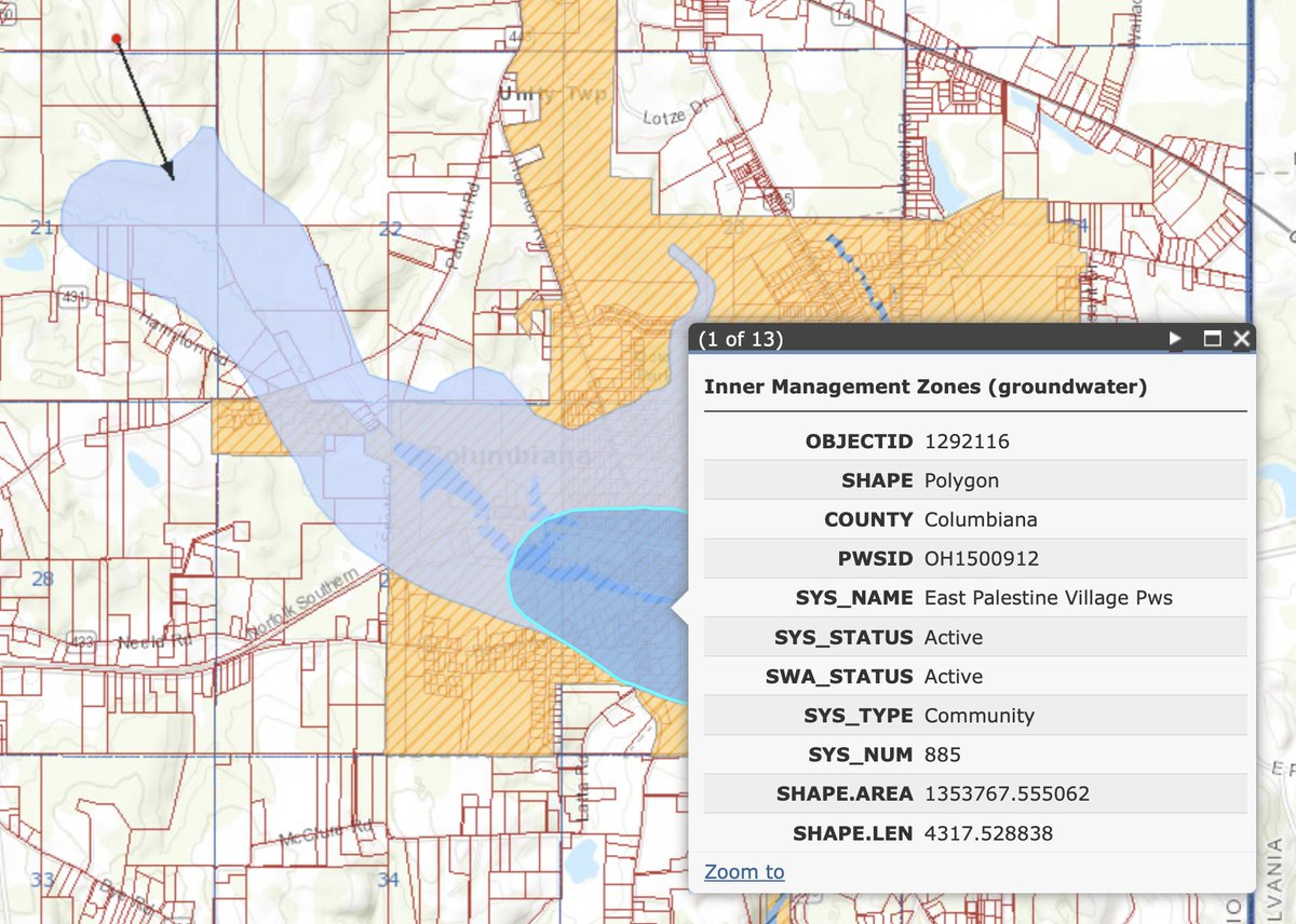
Oopsie - caught another @OhioEPA oversight. The area in blue is a "Source Water Protection Area". The EPA is telling you it's 1.4 miles from the train wreck. Thats TRUE.

However, it's 0.04 miles from Sulphur Run which is a toxic rainbow. Demand answers. #EastPalestineOH
You can view this raw data here:
gis.ohiodnr.gov/MapViewer/?con…
They commented because we pressure them. 🙏

• • •

Missing some Tweet in this thread? You can try to force a refresh
 

Keep Current with 🇺🇸 Frankly Frank 🇺🇸

🇺🇸 Frankly Frank 🇺🇸 Profile picture

Stay in touch and get notified when new unrolls are available from this author!

Read all threads

This Thread may be Removed Anytime!

PDF

Twitter may remove this content at anytime! Save it as PDF for later use!

Try unrolling a thread yourself!

how to unroll video
  1. Follow @ThreadReaderApp to mention us!

  2. From a Twitter thread mention us with a keyword "unroll"
@threadreaderapp unroll

Practice here first or read more on our help page!

More from @CastiglioneFrnk

Nov 11
“A dull knife is a dangerous knife” - Frank

Here’s a quick tutorial on what I used and how I knife sharpen.

Video below shows the sharpness I was looking to achieve. This is before polishing or leather strope, which makes them even sharper.

🧵👇
What you’ll need:

(1) Quality steel knives. Don’t waste your time on junk knives they don’t sharpen well.

(2) Ken Onion Work Sharp belt sharpener.

(3) Time and patience. 4.5 hours to reproduce, grind and sharpen 20 knives. Image
My knives had chips, nicks rust and were dull.

Step (1) was to use the roughest belt to grind the blades until I couldn’t feel any chips on the cutting edge by drawing the knife 90 degrees to the belt. Belt on the lowest speed setting. Destroy the edge and rebuild.

Image on towel shows the edges rebound. No cops, and definitely no cutting edge.
Read 7 tweets
Aug 13
Im in 😎 Image
No updates yet Just waiting beep boop music. 196k people are in.
Nothing happening yet. Still beep boop music.
Read 92 tweets
Dec 5, 2023
Reports this is the #arlington explosion guy. Posts indicating “THEY” are conspiring to make his death look like a 988 (suicide). Totally bonkers posts. Blaming ESPN app, ramblings, etc. 😯👇

#explosion #arlingtonVA #JamesYoo
Image
A man named James Yoo, listed in public records as the resident of the address to which police were initially dispatched, has been repeatedly posting paranoid screeds on his Linkedin account. One post from three days ago rants against his neighbors in the adjoining duplex unit.
Image
Read 11 tweets
Feb 25, 2023
Why is Frank so focussed on the groundwater? Creeks interact with aquifers (underground water).

My dummy interpretation of this geological information is that there is direct interaction between the creeks and the water aquifer under #EastPalestine P49
ohiodnr.gov/static/documen…
Please keep in mind, I'm not a geologist. But I can read. So I am sharing my readings with you. Do your homework. Ask the questions. Hold people accountable. They haven't been truthful so far.
Oops another #EPA typo ! The Potable City water pump intakes may be 56-83 feet below surface, but the ground water is only 18 feet below surface. How do I know? US Geological Surveys. nwis.waterdata.usgs.gov/usa/nwis/gwlev…
Read 6 tweets
Feb 24, 2023
Live - @ErinBrockovich feed - if you use your phone you must go LANDSCAPE mode, full screen. #EastPalestineOhio

news5cleveland.com/news/east-pale…
Erin Brockovich is bringing it hard. She is 100% on point. This is a long game.

And people are tough. They can handle the truth.

Be truthful @OhioEPA - not honest; be truthful. @ErinBrockovich
And we have the worst camera man ever @WEWS
Read 4 tweets
Feb 24, 2023
Why did the @OhioEPA remove this document from their website? It is the 2/4/2023 pre-controlled burn Surface Water test results.

They took samples right next to the city water wells.... ImageImageImageImage
Why is this important? Because Sample ID EPD-SW-03-01-020423 taken on 2/4/2023 before the "controlled" explosion showed elevated levels of Benzo(a)anthracene and Chrysene right next to the Potable City Water Wells.

PRE EXPLOSION ImageImage
It would be logical to conclude that after 150,000 gallons were spilled and immolated that much of this would up going to the creeks near the City Water Wells.

And since 2/4/2023 no one has produced a readable Surface Water Analysis. And this analysis has since been deleted.🤔
Read 8 tweets

Did Thread Reader help you today?

Support us! We are indie developers!


This site is made by just two indie developers on a laptop doing marketing, support and development! Read more about the story.

Become a Premium Member ($3/month or $30/year) and get exclusive features!

Become Premium

Don't want to be a Premium member but still want to support us?

Make a small donation by buying us coffee ($5) or help with server cost ($10)

Donate via Paypal

Or Donate anonymously using crypto!

Ethereum

0xfe58350B80634f60Fa6Dc149a72b4DFbc17D341E copy

Bitcoin

3ATGMxNzCUFzxpMCHL5sWSt4DVtS8UqXpi copy

Thank you for your support!

Follow Us!

:(