
1/ CONQUERING CRIMEA: PART 1
Since 2014, Crimea has been under Russian control. Ukraine, naturally, wants it back. But what does history show about the challenges of reconquering it? In a series of threads, I'll look at the lessons of past wars.
Since 2014, Crimea has been under Russian control. Ukraine, naturally, wants it back. But what does history show about the challenges of reconquering it? In a series of threads, I'll look at the lessons of past wars.

2/ Crimea's fascinating military history has been of interest to me for many years – I travelled there in the early 2000s to study its old battlefields, so some of this will be drawn from personal recollections and notes.
3/ Let's review Crimea's physical geography. It's a roughly diamond-shaped peninsula, about 320 km (200 mi) east to west by about 200 km (120 mi) north to south. It's mostly flat, apart from the Crimean (or Yayla) Mountains in the far south, which are up to 1,500m (5000 ft) high.

4/ Crimea borders the Black Sea on its west and south sides, and the Sea of Azov in the east. It's separated from Russia by the narrow Kerch Strait, across which Russia has built Europe's longest road and railway bridge to link it to the Russian mainland.

5/ The peninsula's climate is almost subtropical in the far south, but in the north and centre it's mostly arid, as a 2018 vegetation map highlights. Agriculture is dependent on an irrigation canal that runs from the Dnipro river in the Kherson region.

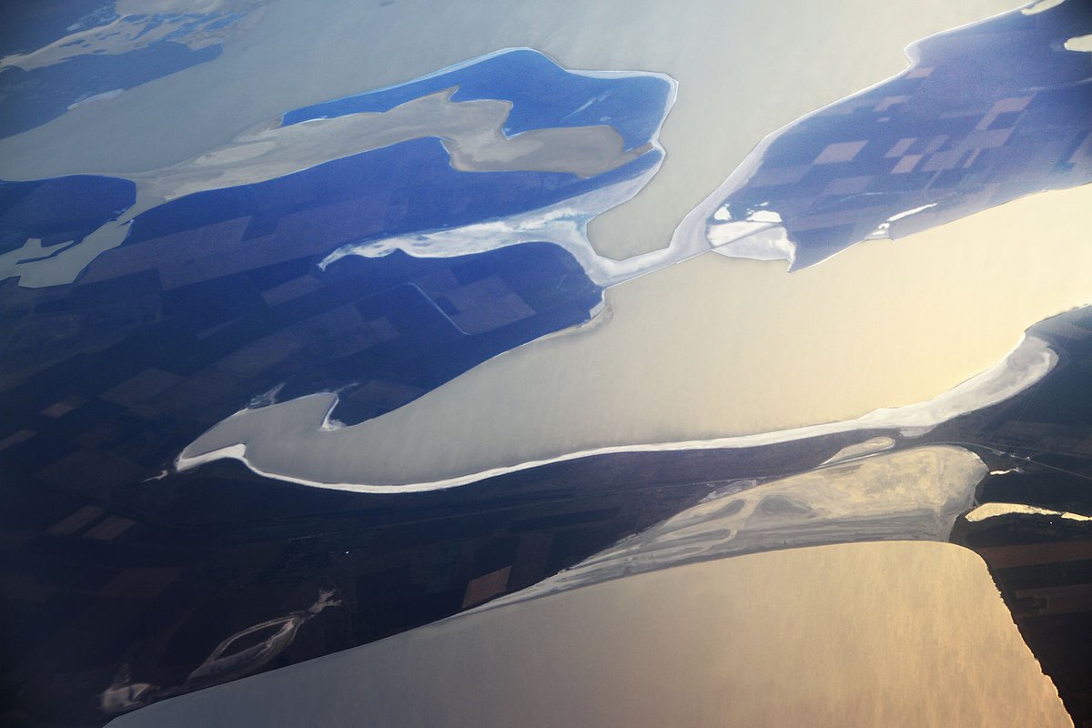
6/ Crimea is separated from the Ukrainian mainland by the Syvash, an area of salt lagoons and marshes which connects to the Sea of Azov via a narrow strait. It's also known as the Putrid or Rotten Sea for its pungent smell in the summer. (This image shows its *natural* colours.)

7/ The Syvash covers around 2,500 km² (965 mi²) and is up to 35 km (21 mi) wide, but is very shallow – only about 3 m (10 ft) deep at maximum. In some places and at the right times, it can be forded on foot. This is militarily significant, as we'll see.
8/ There are only three narrow places along the entire 100 km (62 mi) long northern flank of Crimea where the peninsula is connected to the Ukrainian mainland. This is why Crimea has often been called a "natural fortress", and makes it a difficult place to invade.

9/ From east to west, these places are the:
🔺 Arabat Spit
🔺 Chonhar Peninsula
🔺 Perekop Isthmus
All three of these have been used to invade Crimea, as we'll see in later threads in this series.
🔺 Arabat Spit
🔺 Chonhar Peninsula
🔺 Perekop Isthmus
All three of these have been used to invade Crimea, as we'll see in later threads in this series.
10/ For completeness we should mention the Kerch Strait as an entry point, as that's also of military importance. It's only 3.1 km (1.9 mi) wide at its narrowest. As well as the bridge, it's also crossed by ferries from Port Krym to the Chushka Spit on the Russian side.

11/ The Arabat Spit is a 112 km (70 mi) long sand spit – the longest in the world – which is only 270m (885 ft) wide at its narrowest point. It's low and exposed, relies on two bridges to connect it to the Ukrainian mainland and only connects to Crimea at its far southern end.


12/ There is no proper road along the spit, only a sandy track, although Russia has suggested that it might create a new road to improve Crimea's connection to the Ukrainian mainland. Currently, though, it would be difficult for an army to pass along it.

13/ The Chonhar Peninsula is a narrow wedge of land extending south from the Ukrainian mainland into the Syvash, 20 km (12 mi) west of the Arabat Spit. Two road bridges and one railway bridge at its tip carry transport routes from Melitipol in Ukraine across the Syvash.

14/ The Perekop Isthmus is the only unbridged link between Crimea and the Ukrainian mainland. It's only 9 km (5.5 mi) wide at its narrowest point and is of vital military and economic importance. The road, railway line and canal from Kherson to Crimea all come through here.

15/ There are a few small towns on the isthmus. Perekop (pictured below) itself is technically the oldest – a town has existed there since ancient Greek times. Armyansk was founded by Armenian merchants to trade with the Tatars who formerly ruled Crimea.

16/ To the south, Krasnoperekopsk, literally "Red Perekop", is a Soviet town built to house workers at a nearby bromine factory. The village of Ishun a short way further south is also of military significance for its location near three lakes – Krasne, Kyatske and Kyrleutske.

17/ While there have been battles on the Chonhar Peninsula and Arabat Spit, the Perekop Isthmus has been recognised for millennia as the gateway to Crimea. A line of fortifications has existed across the isthmus for at least 2,500 years, and has repeatedly been fought over.

18/ The ancient Greek name for Perekop, Taphros, means 'dug-out place'. It likely reflected the presence of a ditch across the isthmus at this point. The ditch is still there – it's clearly visible from space – and was fortified further between the 15th and 20th centuries.

19/ The fortification, known variously as the Perekop Wall, Turkish Wall or Tatar Ditch, is up to 45m (150 ft) wide and was originally up to 20m (65 ft) deep. It was anchored at the Perekop end by the now ruined Or-Kapi fortress, from which Perekop takes its name.


20/ The fort was originally built by the Tatar Crimean Khanate in the 15th and 16th centuries to defend Crimea from the Mongol-descended Golden Horde. After the Horde's final defeat, the Tatars launched raids into the north to capture Slavs for the Ottoman slave trade.

21/ Not surprisingly, this caused conflict with the Cossacks who lived along the Dnipro. This brings us to the invasion of Crimea in 1675 by the Cossack Ivan Sirko, which will be the subject of my next thread in this series. /end

Here's part 2:
https://twitter.com/ChrisO_wiki/status/1641172285967982594?t=0fwlozvpIBSG992zx7QgtQ&s=19
• • •
Missing some Tweet in this thread? You can try to
force a refresh


