1/ Where is the old stream bed of the Konka River at Enerhodar referenced by @energoatom_ua? A #NAFOWeather 🧵
"The Konka River, which now runs along the cooling pond of the ZNPP and was under the Kakhov Reservoir as an underwater current, separated into its historical channel."
6/ 1950s era Army Mapping Service map (credit: @ChrisO_wiki) created from pre-dam 1940s data sources.
RE: "Historical Channel" - Below Dnipro, Dnipro River is contained in a braided channel with the Konka River and Pereval Rivers in a wide marshy plain. en.wikipedia.org/wiki/Braided_r…
Water access now denied to City of Kryvyi Rih (population 635,000) with Kryvyi Rih canal intake above #KakahovkaReservoir water level.
Sentinel 1 SAR Imagery: 1 and 9 June 2023 (before/after Russian destruction of #KakhovkaHPP). sentinelshare.page.link/6RD4
It is difficult to imagine time & space of hardships for the people of south Ukraine caused by the destruction of #KakhovkaHPP. Flooding is only the beginning of a water scarcity disaster chain. Mykolaiv's experience provides clue to what awaits the south. reuters.com/world/europe/h…
1/ This thread rebuts claims made by Mikael "Vatnikersson" Valterson against @Ukrhydroenergo, saying Ukraine's state dam operator, "was the original culprit" in destroying the #KakhovkaHPP and exacerbating dam destruction flooding. A #NAFOWeather 🧵
2/ As "Readers" pointed out, the video Vatnikersson used to "prove" Ukraine sent water downstream to #KakhovkaHPP was almost 2 months old. The video proves nothing. Vatnikersson made no attempt to clarify the temporal discrepancy; the tweet is still posted.
3/ Vatnikersson made several allegations in his tweet that accused Ukraine of destroying its own dam as well as causing post-dam failure flooding. I will unpack these allegations.
Sediment has accumulated behind #KakhovkaHPP dam since 1955. Russian destruction of the dam released 18 cubic kilometers of stored water flushing 68 years of sediment into the northwest Black Sea, silting Dnipro harbors and damaging fragile marine ecosystems.
Upper Left: Surface Current Direction and Velocity
Upper Right: 5 June - pre-flood
Lower Left: 9 June - Sediment advanced to Odesa
Lower Right: 10 June - Sediment advanced to Choromorsk
Satellite images are from MODIS True Color go.nasa.gov/3oPRMQH
1/ Soil moisture update: While #MudSeason is "officially over", locally heavy rain can and will degrade trafficability for periods of time. A #NAFOWeather 🧵
2/ BLUF: Updated soil moisture/trafficability matrix similar to 25 April forecast with a 1 month delay in seasonal drying conditions due to above average April rain. Last week of May had several thunderstorm days & locally heavy rain but overall dry conditions since May 1st.
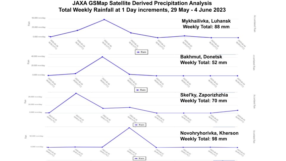
3/ As stated in previous tweet, some locations had heavy rain including eastern Kherson/northwest Zaporizhzhia, northeast Donetsk and southern Luhansk in the last week of May. However, June has been mostly rain free.
1/ I'm supporting @exit266 documenting the Black Sea Grain Initiative #BSGI#BlackSeaGrainInitiative providing marine wx impacting transit & inspection operations. This🧵is a bit off-topic, analyzing weather impact on @CarnivalCruise Sunshine cruise, 21-27 May 2023.
2/ On the evening of 26 May 2023 through mid-day 27 May 2023, the @CarnivalCruise ship #Sunshine experienced high winds and waves on its final leg of 21-27 May 2023 cruise from Charleston, South Carolina to The Bahamas Islands. Cite: @flyerscaptain@CrewCenter@CruiseHive@CNN
3/ First... some terms and definitions for the landlubbers
2/ Loop of several cloud-free Sentinel-2 passes of #KakhovkaHPP this month, latest 29 May 2023, show white turbulent flow downstream of sluice gates.
3/ @lhinnant published an article "Damage to Russian-occupied dam submerges Ukrainian reservoir island community" 25 May 2023 for @AP. Worth a read. apnews.com/article/ukrain…