NWS Nashville Profile picture
Official Twitter account for the National Weather Service Nashville. Details: https://t.co/IdAG5sjPmt
Jan 5, 2022 4 tweets 3 min read
OK. OK. I'll make a thread. Hate leaving the Twitter crowd out of the mix...

Here's the latest thinking on totals. This is up from earlier today and the trends are higher. Doesn't mean it'll happen, but these are the trends. #tnwx

1/4 On top of this, if you live south of I-40 and closer to the Alabama state line, you're probably going to start out tomorrow with a mix of freezing rain and sleet (expecting less than 1/10th of an inch) and then the snow. #tennessee

2/4
Jan 3, 2022 4 tweets 2 min read
Here's a look at Google Maps with Live Traffic Data from 930pm CST. Tell me where the snow has accumulated on the roads, bridges, and overpasses without looking at radar! Hint: Where the interstates are orange and red! Image 
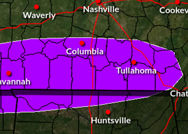
We just received a few reports from Wayne and Lawrence Counties in Tennessee of snowfall measurements between 1.75 inches-2.5 inches. These are the highest amounts so far reported in Middle Tennessee.
Jan 2, 2022 4 tweets 2 min read
We're getting a LOT of questions about two things this afternoon:
- Timing/Duration of the Snow
- Expected road conditions across Middle Tennessee.
There's only one of those we can help with, so here's a graphic below to help in figuring out snowfall timing for your location. Image As of 4PM CST, the changeover line for all snow is near I-65 now and will continue to push east through the evening. Snowfall amounts are still on track with our previous tweet.
Dec 17, 2021 12 tweets 7 min read
1/12 Here are preliminary maps of the 15 #tornadoes from December 10-11, 2021 across #MiddleTennessee. Please note that the maps and all tornado information is PRELIMINARY and subject to change! #tnwx 2/12 #1 was a long track EF3 tornado that moved from west Tennessee across the northwest corner of Middle Tennessee and into southern Kentucky
Dec 15, 2021 4 tweets 1 min read
1/4 UPDATE: We've determined a 14th #tornado occurred from the severe storms on Dec 11 - an EF-0 in western Davidson Co. that tracked from Whites Bend across Bells Bend to north of John Tune Airport & through Bordeaux. Path length 9.6 miles, path width 100 yards, max winds 85 mph 2/4 Damage in Madison from Briley Parkway at Gallatin Pike northeastward to Neelys Bend Road was determined to be from a swath of severe straight line winds around 1/2 mile wide and 2 miles long, with maximum winds estimated up to 85 mph
Feb 12, 2021 6 tweets 2 min read
Several rounds of active weather are set to start early this weekend. A mix of liquid and freezing rain will begin overnight and continue through the day on Saturday. Locations along and east of I-65 may experience the greatest impacts with less than 0.10" ice accumulation expected. Minor travel impacts are possible, especially where roads are untreated.
Mar 7, 2020 5 tweets 1 min read
(1/5) Please share this important post.

It is critically important that everyone have at least TWO ways of receiving warning information. This is especially important here in Tennessee where we lead the nation in nighttime tornadoes. We saw this Monday night. (2/5) No technology is 100% dependable. Phone lines can go down. Weather can take down transmitters. Cell phone settings may override the audible alarm on weather alerts. Please, don't put your life in the hands of only one warning method.
Mar 3, 2020 4 tweets 2 min read
So let's recap what our damage survey teams found today...

Looks like it's quite possible we have one to maybe two long-track tornadoes across Davidson, Wilson, and Smith Counties. In the coming days, we will determine if these tornado paths are actually one/two tornadoes. Damage from the individual neighborhoods we were able to survey today:
John C Tune area: EF-2 (130mph)
Germantown/North Nashville: EF-2 (125mph)
East Nashville/Five Points: EF-3 (136-140mph)
Donelson: EF-3 (160-165mph)
Mt. Juliet: EF-3 (155-160mph)
Lebanon in Smith County: EF-1