NWS New Orleans Profile picture
Official Twitter account for the National Weather Service New Orleans. Details: https://t.co/iCJUV7vGsN
Jan 22 6 tweets 3 min read
Now that the winter storm has passed, the big story today will be the lingering impacts (ice covered roads) and extremely cold temperatures!

Please, follow along as we break it all down with what to expect today thru the weekend...#lawx #mswx

(1/6) ⚠️ Today: Ice covered roadways from yesterday's snow will continue to impact travel, as temps will struggle to reach above freezing for most areas. Travel is NOT RECOMMENDED but if you must travel, check road conditions and plan accordingly! #lawx #mswx (2/6) Stay off the roads today! For more tips, visit www.ready.gov
Jan 20 4 tweets 2 min read
(1/4)⚠️ 5PM Update:

We still have a Winter Storm Warning across all of the area for tonight through Tuesday Evening. Roads will be dangerous, so consider delaying travel tomorrow, if possible. If you do have to travel, use extreme caution. Prepare for Winter Weather. Winter Storm Warning and Winter Weather Advisory in effect Late tomorrow night through Tuesday evening. SAFETY: Monitor the latest forecasts for updates. Consider delaying all travel. Use extreme caution if travel is absolutely necessary. (2/4)🥶 There now is also an Extreme Cold Warning for the entire area Tuesday night and Wednesday morning for wind chills ranging from 8-15 degrees.

Make sure to protect the 4 P's: people, pets, plants, and pipes! A graphic from the National Weather Service New Orleans/Baton Rouge, LA, titled "Dangerous Cold Tomorrow Night!" highlighting an Extreme Cold Warning for southeastern Louisiana and southern Mississippi. The map shows affected areas in dark blue, including cities such as McComb, Baton Rouge, Hammond, Slidell, New Orleans, and Gulfport. Key information includes the warning period from 6 PM Tuesday to 9 AM Wednesday. The dangers of extreme cold, such as hypothermia and ruptured water pipes, are emphasized. Safety tips include checking on vulnerable individuals, preventing water pipes...
Jan 19 4 tweets 2 min read
A Winter Storm Warning in now in effect for SE Louisiana as well as SW &coastal Mississippi.

Moderate to major impacts are expected & travel should be avoided if at all possible Tuesday & Wednesday as snow will likely not have a chance to melt during the day Wednesday.

(1/4) Prepare for Winter Weather. Winter Storm Warning Late tomorrow night through Tuesday evening. SAFETY:Monitor the latest forecasts for updates. Consider delaying all travel. Use extreme caution if travel is absolutely necessary.  Heavy snow is forecast to affect the area, with 4-6" of snow for areas generally north of I-10/12 and 1-3" south of I-10/12, including the New Orleans metro area.

The heaviest snow will fall during the day Tuesday and hazardous travel conditions are expected.

(2/4) Heavy snow forecast indicating most likely snow amounts of 4-6 inches for areas north of interstate 10 and 12 and 1-3 inches for areas south of interstate 10 and 12. A few places could see totals as high as 8-12 inches.
Jan 18 5 tweets 2 min read
Here's the latest on the upcoming winter storm. Cold weather impacts will be greatest Monday through Thursday, but hazardous travel is also expected Tuesday due to wintry precipitation.

(1/ ) Timeline of winter weather impacts across southeastern Louisiana and southern Mississippi Sunday through Friday. The main impacts are Monday through Thursday with the greatest impacts on Tuesday due to snow. With the cold temperatures and wind chills, a Cold Weather Advisory is in effect for the entire area tomorrow night and then again Monday night through Tuesday. Extreme Cold Watches/Warnings will likely be needed for Tues/Wed.

(2/ ) Cold weather advisory graphic indicating wind chills of 10-15 degrees in northern areas and 15-25 degrees in southern areas Sunday night and again Monday night through Tuesday. Safety: Wear appropriate clothing. Keep pets indoors as much as possible. Ensure portable heaters are used correctly.
Jan 17 7 tweets 5 min read
⚠️👉 An active weather pattern is on the horizon, with major to extreme impacts expected in the days ahead. Here's a day-by-day breakdown, starting with this evening - Sat:

Scattered rain/storm chances tonight thru Saturday. Warm highs Saturday in the 70's. #lawx #mswx (1/7) Frigid Cold Weather on the Way! Overview of What to Expect Next Week + Winter Weather Potential? Saturday, Periods of scattered showers and storms. Some heavy. Sunday, Colder & Breezy! Wind chills 20-30F in the AM. Monday, Hard freeze areas along and north of I-10/12. AM wind chills upper 10s to 20s. Tuesday, Another hard freeze – same areas.  Frigid Wind Chills! Snow for most areas? Wednesday, Hard Freeze – same areas. Frigid Wind Chills! Lingering impacts from snow! Thursday, Hard Freeze: I-10/12 N. Frigid Wind Chills! Friday, Near/around freezing temps AM. Sunshine returns? A strong, arctic front blows through Sat PM/Sun AM. It'll be chilly & sunny Sunday but dry. Then, our first in a series of extremely cold nights arrives Sun night/Monday morning. #lawx #mswx (2/7) Widespread Freeze/Hard Freeze Monday Morning. Frigid Temperatures Monday Morning. Temperatures in the low to mid 20’s for a large majority of the area. Now is the time to Prepare. Have in plan a place for the elderly and those who don’t have reliable access to warm shelter. Plan to bring animals in or prepare a shelter for them to stay warm. Make sure there is a way to get fresh unfrozen water. Check and protect pipes. Replace old and damaged insulation if needed.
Forecast duration of below freezing temperatures will range from 10 to 17 hours for northern areas, to 3 to 10 hours for southern areas Monday morning. Dangerously cold minimum wind chills are expected to be in the teens for all areas Monday morning.
Jan 17 7 tweets 3 min read
👉 There's plenty to discuss in the in the medium-to-extended forecast time range for the next 3-7 days. Let’s break it down day by day in this 🧵 thread with everything we know (1/7)... #lawx #mswx But first, looking at the forecast Friday through Saturday

Overall nice Friday! Rain/storm chances increase Fri night. Rain could be heavy at times. Storms continue Saturday mainly for areas along/south of I-10/12 then clears out Saturday night, turning colder! #lawx #mswx (2/7) Friday & Saturday Forecast. Mainly mild Friday with no rain. Rain chances increase Friday Night with lows in the 50’s. Rain and storm chances continue Saturday mainly for central/southern areas with highs in the upper 60’s to low 70’s. Clearing out and much colder Saturday night with lows in the low to mid 30’s for northern areas Sunday morning, 40’s southern areas.
Feb 5, 2024 7 tweets 5 min read
👋 It's National Weatherperson's Day! This year, we wanted to share with you the amazing forecasters and staff here at NWS New Orleans/Baton Rouge that work 24/7 providing forecasts and life-saving warnings across Southeastern Louisiana and southern Mississippi! (1/7) Meet the NWS New Orleans Staff graphic! Get to know the people behind the mission! 🏆 Starting out with our LIX Management Team! Meet Lauren Nash (WCM) and Jared Klein (SOO). Our dedicated managers are the backbone of our operations. They provide exemplary leadership, facilitate training, and build partner relationships. (2/7) Meet Lauren Nash! NWS Warning Coordination Meteorologist (WCM). Lauren is responsible for making sure what we send out to the world is understood and received by all partners, the public, media and government officials. She also coordinates all outreach from the office, such as STEM events, school visits and other public events. Lauren is passionate about social media and how to best utilize that to get our message across and has been involved with it since it started in the NWS. Lauren also became a meteorologist because she grew up in tornado alley and is always looking for ways to educat...
Meet Jared Klein! NWS Science and Operations Officer (SOO).Jared leads the office's science and training programs. A lot of his efforts involves integrating the latest scientific techniques and tools into operations to enhance weather forecasting and warning services. Jared is also responsible for providing staff training and fostering professional growth among forecasters, ensuring a culture of continuous learning and skill enhancement. Additionally, he collaborates with research institutions and other partners to improve the overall accuracy and effectiveness of our weather services.
Sep 1, 2023 9 tweets 4 min read
The numbers are in & this summer was H-O-T.

ALL our automated sites tied/broke their warmest summer records (Jun-Aug), some by astounding margins.

We don't have enough space to go over every record that was set, but this thread will break down the more impressive ones.

(1/9) Text next to clipart of a record on fire with the NWS logo in the middle of the record. The text reads as follows. Record Breaking Summer of 2023.  Every one of our automated stations broke or tied their records for warmest summer (June-August)!  This includes climate sites at Baton Rouge and Gulfport, with records back to the 1890s!  New Orleans (MSY), Gulfport, Slidell and Pascagoula all broke their all-time highest temperatures, and New Orleans Lakefront tied its all-time highest temperature! Numerous monthly and daily records were also broken! Baton Rouge broke its warmest summer on record by an almost unfathomable 2.8 degrees! Records go back to 1892.

The all-time high temperature wasn't reached, but there were an astounding 30 days with a high at or above 100 degrees! (Avg back to 1892 is only 1/year)

(2/9) Text next to clipart of a record on fire with the NWS logo in the middle of the record. The text reads as follows. Warmest summer on record, beating 2011 by a staggering 2.8 degrees! August and July of this year are now the two all-time warmest months on record, and June was the warmest June on record. 30 days with a high temperature of 100° or warmer! An astounding 27 days with a low temperature of 80° or warmer! The previous record was only 4, set in 2019. 21 of the warmest 25 days on record occurred this summer!
Aug 28, 2021 9 tweets 7 min read
There is some confusion surrounding the impacts that will occur across our area. Here is a breakdown of all the impacts we are expecting from Hurricane #Ida below by area/region. #Ida is a dangerous hurricane and it WILL produce LIFE-THREATENING impacts. #mswx #lawx For the Baton Rouge metro area: Expect winds >110mph sustained. Rainfall 10-15” with 20”+ possible. Brief tornadoes possible. #lawx
Aug 28, 2021 6 tweets 3 min read
We continue to monitor Ida as it approaches, expected to make landfall Sunday afternoon/evening. A hurricane Warning is in effect for areas of southern/central LA. A Tropical Storm Warning is in effect for parts of coastal/southern MS and western LA. #LAwx #MSwx We want to continue to stress that this WILL be a DANGEROUS and LIFE-THREATENING storm. There WILL be significant wind damage. Prepare for widespread power outages and tree/structural damage in these purple/red areas on the graphic below.
Aug 27, 2021 5 tweets 5 min read
🌀 4AM CT Tropical Storm Ida Thread: Ida continues northwest south of Cuba, expected to enter into the SE Gulf tonight/early Saturday. Ida remains on track to become a major hurricane, delivering significant impacts to portions of southern LA and southern MS. #lawx #mswx (1/5) 🍃 A Hurricane Watch is in effect for portions of southeastern LA, coastal MS and adjacent marine areas. Damaging winds will be possible beginning overnight Saturday along the coast, spreading inland into Sunday. #lawx #mswx (2/5)
Aug 26, 2021 6 tweets 7 min read
🌀 As we gear up for the potential impacts from TD9 which could be #Ida later today or tonight there are a few thing we would like everyone to understand and be prepared for. #LAwx #MSwx Image 
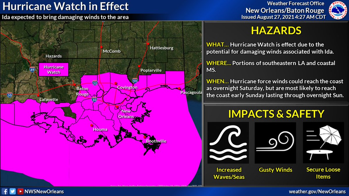
💆 DO NOT PANIC! Be prepared, stay up to date, and try to remain calm. You have time IF you begin today. If the track continues as forecast, conditions will likely begin to go downhill late Saturday. This gives you today, Friday, & even early Saturday. #LAwx #MSwx Image
Oct 28, 2020 6 tweets 7 min read
🌀10PM CDT Update on Tropical Storm #Zeta. Starting to see some steady strengthening trend now with max winds at 70mph. Impacts across parts of SE LA and southern MS remain likely on Wednesday.

Lets break down each specific threat one at a time...(1/6) 1. 💨 Wind: Strong winds will be the primary threat when #Zeta makes landfall. These winds may lead to isolated to scattered power outages, some tree damage and even some damage to some structures - especially near the center of the track. (2/6) #lawx #mswx
Oct 27, 2020 6 tweets 7 min read
(1/6) 🌀 7PM CDT Update on Hurricane #Zeta. No major changes this evening as #Zeta continues towards the NW with an eventual, brief landfall expected across the Yucatan later tonight. We are still anticipating impacts, some major across the area Wed & Thu. Stay tuned! #lawx #mswx 
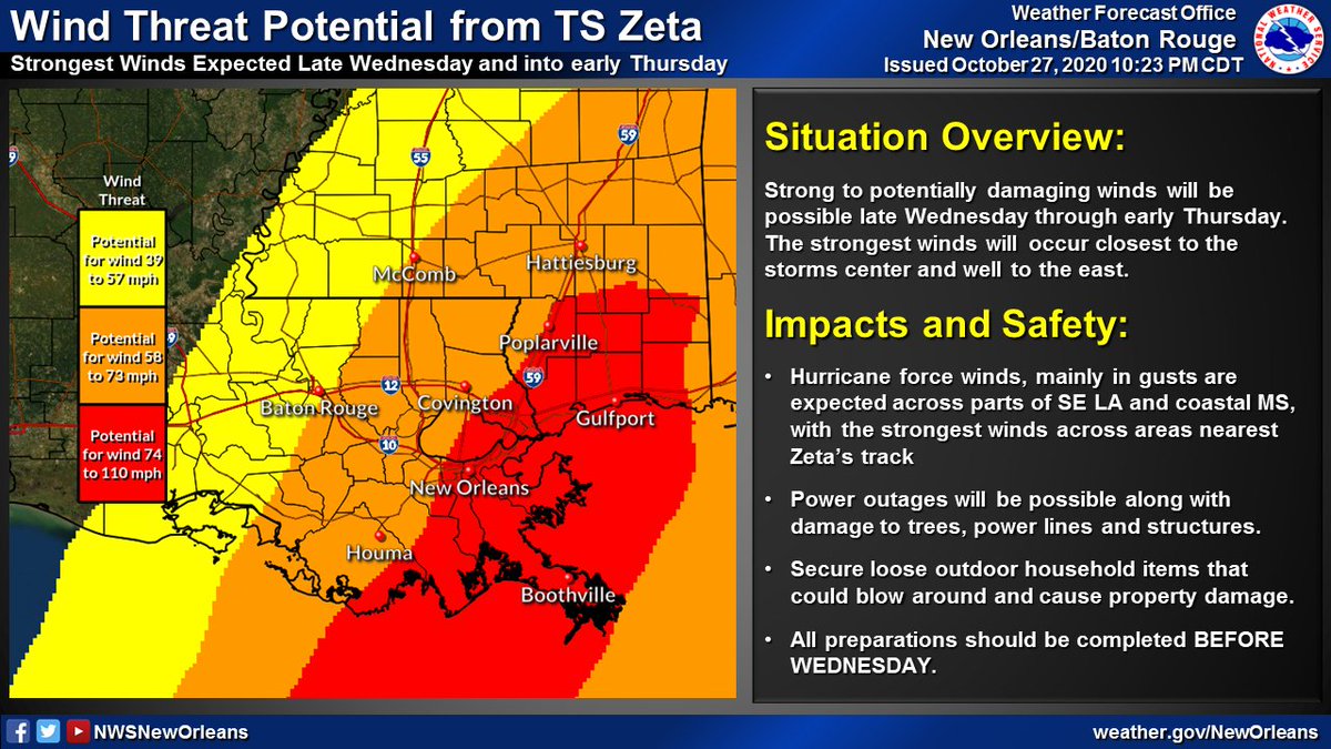
(2/6) Hurricane and Tropical Storm Watches remain in effect for a large portion of SE LA and coastal MS. Strong, potentially damaging winds may be possible in association with #Zeta late Wednesday through early Thursday. #lawx #mswx
Oct 8, 2020 5 tweets 6 min read
🌀 (1/5): Here's the latest with Hurricane #Delta as of 10AM CDT. Some slight strengthening was noted by recent aircraft recon observations with a steady strengthening trend now expected through the day today. Impacts still remain likely across our area Friday. #lawx #mswx 💨(2/5): No changes to the Tropical Storm Watches and Warnings that remain in effect. Expect winds to increase across coastal areas of SE LA later today/tonight, and spread inland during the day on Friday. #lawx #mswx
Oct 8, 2020 5 tweets 5 min read
Here is the 4AM update on Hurricane #Delta along with a thread on the latest local hazards expected from Hurricane #Delta.

Delta will bring potential for:
🌊Life-threatening storm surge flooding
🌬️Damaging winds
⛈️Heavy rain and flash flooding

#lawx #mswx
(1/5) Locally, the strongest winds from #Delta are expected across areas nearest the Atchafalaya River.

Strong winds could result in:
🔌Power outages
🌳Minor to moderate damage to trees/power lines
🏠Damage to a few structures from falling branches/trees

#lawx #mswx
(2/5)
Oct 8, 2020 5 tweets 5 min read
Here's a thread on the latest local hazards expected from Hurricane #Delta.

Delta will bring potential for:
🌊 Life-threatening storm surge flooding
🌬️ Damaging winds
🌧️ Heavy rain and flash flooding

#lawx #mswx
(1/5) Delta will bring potential for life-threatening storm surge Locally, the strongest winds from #Delta are expected across areas nearest the Atchafalaya River.

Strong winds could result in:
🔌 power outages
🌳 minor to moderate damage to trees/power lines
🏠 damage to a few structures from falling branches/trees

#lawx #mswx
(2/5) Strong to potentially damaging winds will be possible Friday
Oct 7, 2020 6 tweets 7 min read
🌀 (1/6): Tweet thread with the latest on Hurricane #Delta. The 10AM position has #Delta continuing to cross the Yucatan & will emerge into the Gulf later today. No major changes to the forecast track as impacts, some significant, may be likely later this week/weekend #lawx #mswx 🌀 (2/6) Tropical Storm and Hurricane Watches are now in effect for portions of SE LA and S MS. Expect gusty winds to increase across the area late Thursday and into Friday - lasting into early Saturday. #lawx #mswx
Oct 6, 2020 4 tweets 4 min read
🌀 (1/3) 10AM CDT Update on TS #Delta: Delta is now a major hurricane in the west-central Caribbean. No major changes to the forecast track as impacts remain likely along the northern Gulf coast late this week and this weekend. #lawx #mswx Image 🌀 (2/3) As a reminder, NOW is the time to have a plan! Don't let the recent cool temperatures fool you - it is still Hurricane Season! Impacts remain likely with this system across portions of the northern Gulf coast and you should take it seriously! #lawx #mswx ImageImageImage
Aug 26, 2020 5 tweets 3 min read
Here's a thread with the latest on Hurricane #Laura. It continues to strengthen as it moves toward the NW Gulf Coast. Minor to moderate impacts are expected across portions of SE LA and S MS. #lawx #mswx (1/5) 🌊 Life-threatening storm surge flooding is possible across coastal portions of SE LA generally west of Grand Isle.

🌊 Water levels will be highest during high tide today and tomorrow

🌊 Expect several roads to become impassible and some areas to become inaccessible

(2/5)
Jul 11, 2019 6 tweets 4 min read
(1/6) 5:15p Thu TS #Barry Update

🌧️🌊Flooding continues to be the greatest threat - both from heavy rain and storm surge
🌬️Strong/Damaging winds possible along Barry's track as it could still become a hurricane
🌪️A few tornadoes possible, especially near the coast

#lawx #mswx 
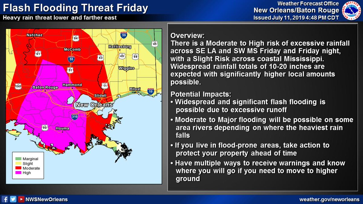
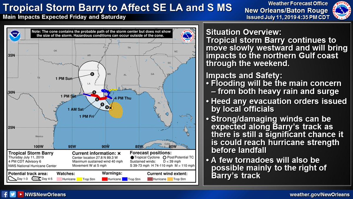
(2/6) Significant flood threat associated w/ #Barry

📏10-20" of rain with significantly higher local amounts possible
⏰Heaviest rain expected Friday through Saturday night
🌧️Heavy rain could lead to widespread/life-threatening flash flooding and moderate to major river flooding