Allan Huffman Profile picture
Christ follower 1st. Met with 20+ years of experience forecasting and modeling BS/MS from NC State Husband to Jennifer Father of 5. https://t.co/aMKO4rG3EI
Jan 12, 2022 11 tweets 4 min read
1) So a look at where we stand now I posted this earlier but you can see that over the last 10 runs the GFS has trended the main disturbance W/SW from OH to OK This allows for less confluence over the NE (cold high pressure) and earlier strengthening/amplification of the main s/w 2) The result is that the GFS now take the primary low into Kentucky, not AL/MS and miller B secondary cyclogensis occurs over the NC coastal plain not off the SC coast. The 6z GFS shown This scenario causes a changeover for most east of the mtns Big snow for The apps/interior NE
Jan 11, 2022 5 tweets 2 min read
1) I looked at the individual EPS members at 12z. And grouped them into 3 scenarios. Op model idea (close to coast or inland track), ENS mean idea (offshore track), and other which is mostly a really suppressed track. I came up with Group 1: 21 Group 2: 22 Group 3: 7 #snow 2) I think this is a better way to look at the ensemble to see what scenario is favored. For now, it is 50:50 mostly with the outside chance we have a much more suppressed solution. I will try and update this each cycle to see how we trend.
Jan 11, 2022 6 tweets 2 min read
Local Weather Summary 1) Sunny and cool today and Wednesday. High around 41 today, low tonight in the low 20s. High Wed around 51. Some increasing clouds Thursday as a disturbance moves towards the area. High 55, low 28. 2) This disturbance could bring a shower or perhaps even a snowflake mixed in late Thursday night. But it will be dry for many and temps in the upper 30s will likely mean all rain for most. But I cant rule out a stray flake. This disturbance will form a strong low off the coast.
Jan 11, 2022 6 tweets 3 min read
1) So for this weekend storm. Right now, to me it looks to have 3 potential paths. 1. The GFS/CMC path which is that there is enough separation between the storm ahead and disturbance behind that the s/w cuts off and becomes neg titled This leads to the big storm idea GFS/CMC 2) Path 2, favored by the ECMWF/UKMET Is that the shortwave cant become neutral or negatively but is positively tilted This is a weaker, flatter, further south scenario Significant strengthening is slower and off shore. This could still bring wintry weather to the South, but less
Jan 10, 2022 11 tweets 4 min read
Local Weather 1) Decreasing clouds today with temps rising into the mid to upper 40s this afternoon. Cold and dry Tues/Wed. Low 23 High 40, low 23 on Tues. Low 20 High 49 on Wed. As a disturbance move east, it will go negatively tilted Thursday and spawn low pressure development 2) Off the Carolinas coast. I have been watching this all weekend, but for now it looks to stay far enough offshore to only bring some showers to the immediate coastal areas. For now, P. Cloudy for RDU, Thurs: High 54, Low 29. P. Cloudy Friday: High 49, Low 31.
Sep 21, 2021 4 tweets 2 min read
Local Weather 1) rain is likely the next couple of days with a general 1-3 inches for many. Some areas of the foothills/NW piedmont and SE NC could see 3-5 inches of rain locally. 2) After the front passes Wed night/Thurs am we see a dry, less humid and cooler weather pattern. Morning lows will be in the 40s in the west and low 50s in the Triangle Friday/Saturday with highs in the mid 70s. Sunday looks nice as well making a wonderful weather weekend.
Aug 2, 2020 4 tweets 2 min read
Here are the major 00z global models and their ensembles. #Isaias will likely stay just off the SE FL coast, although a brief landfall of the center still cant be ruled out. I think landfall will likely be between Cape Romain SC and Cape Fear, NC. I have shifted my track (1/4) 
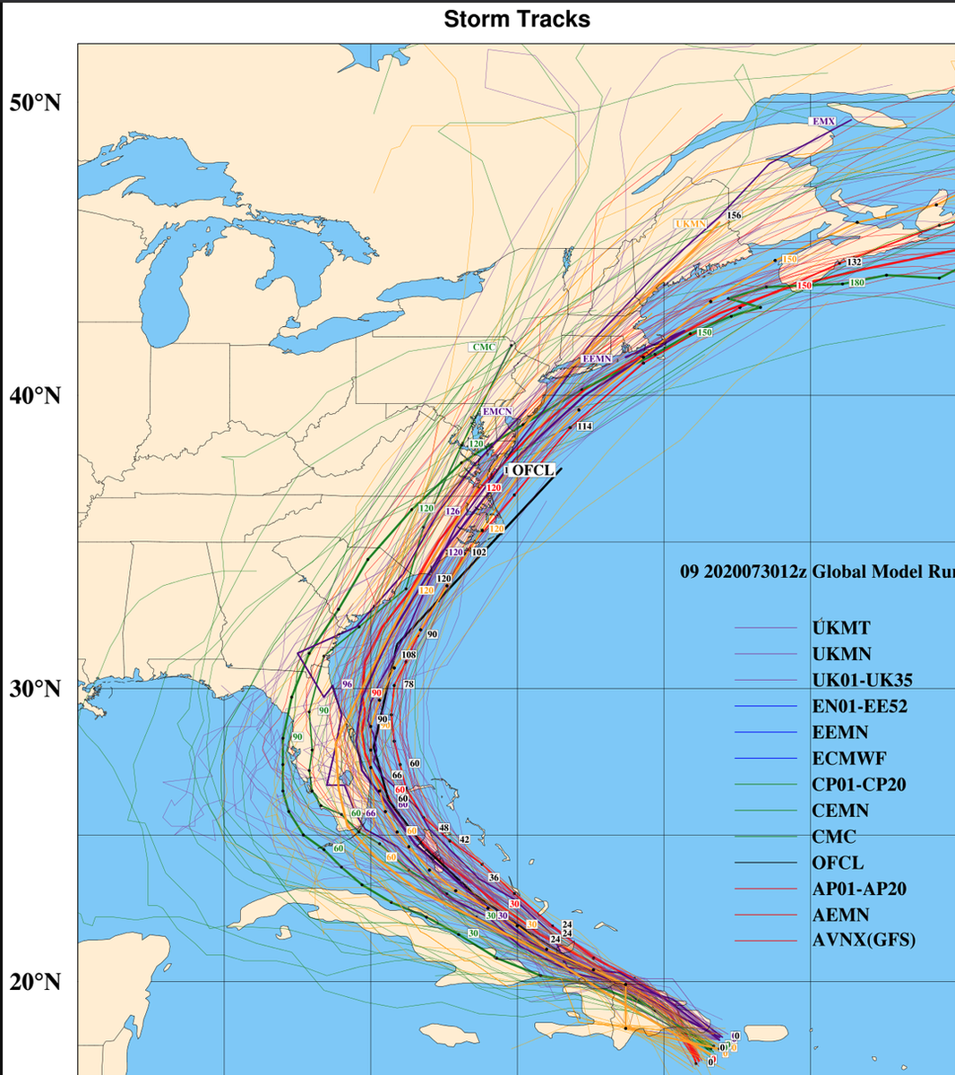
a bit west with landfall of #Isaias near the NC/SC border, I am still a bit NE of the model consensus at the moment. With a track up the NC coastal plain, Tidewater/Delmarva/NE Coast. It does looks more likely that the center will stay mostly onshore on its ride NE. (2/4)
Jul 30, 2020 4 tweets 2 min read
So there has certainly been some convergence on the track forecast today for #Isaias The 12z major global models and their ensembles. It looks like the storm will strengthen into a hurricane as it moves through the Bahamas and towards Florida. I could see cat 1, maybe cat 2.(1/4) 
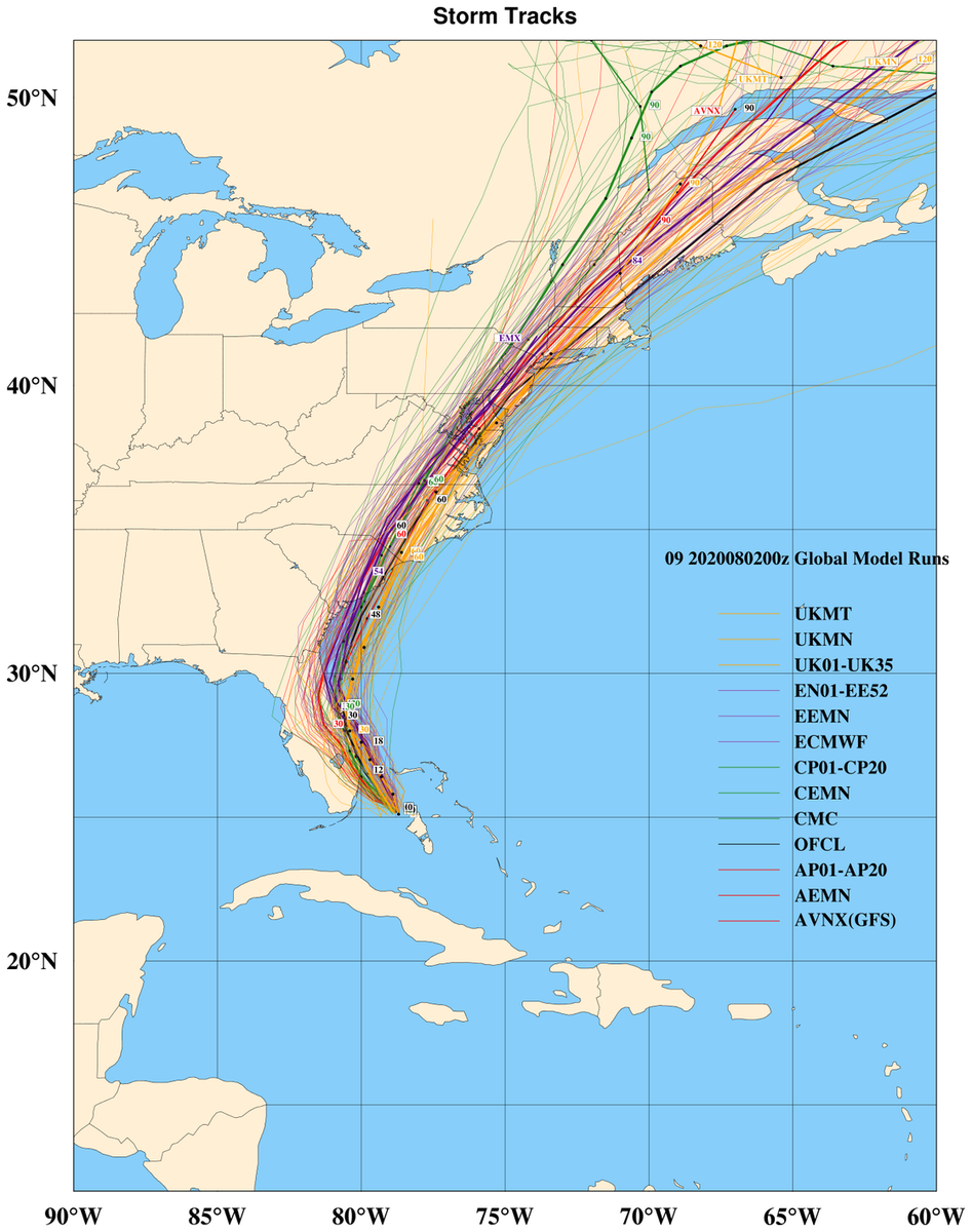
in a high end scenario Some increasing vertical shear could limit intensification or weaken #Isaias this weekend as it moves up just off the FL coast. I like a track just off the GA/SC coast with a threat to the NC coast by Mon/Tues The waters are warm so we could (2/4)