
Keep up-to-date on ShakeAlert System news, updates, and other information. Posts and "likes" are not endorsements.

 .#ShakeAlert powered #earthquake alerts were delivered by the @MyShakeApp and @fema Wireless Emergency Alert System - WEA. You can find this map at: prod-earthquake.cr.usgs.gov/earthquakes/ev… Check out the map - if you are inside the MMI 3 (weak) polygon you might have received an alert.
 Dr. Noha Farghal has a Ph.D. in geophysics from @Stanford. Noha is working on incorporating fiber-optic sensors into the #ShakeAlert system. Check out her recent paper: The Potential of Using Dynamic Strains in Earthquake Early Warning Applications pubs.geoscienceworld.org/ssa/srl/articl…
 Let us know if you got an alert and share screen shots if you want. At this magnitude apps that are Powered by #ShakeAlert can deliver alerts to people who could feel MMI III (weak shaking) or greater. Check out how big the MMI III+ region is on this map. @Cal_OES
 Why is social science important? Apart from sensors in the field, data processing centers, and alert delivery by our partners, people directly interact with #ShakeAlert. Anything that can improve that interaction, which often happens quickly, is critical to keeping people safe.
 Even #ShakeAlert animations are based on research. What went into making this new resource? Every detail counts and geologist Jenda Johnson spent hours getting everything just right. Just to animate Drop, Cover, and Hold On took 100+ individual frames! @ECA @waShakeOut @ShakeOut
 Optimizing how 50+ million people interact with earthquake alerts is critical to the success of #ShakeAlert. Mariah is up for the task and she will be working with researchers at @OMSI and @UOsojc to apply what she learns to real world settings. @OregonOEM @waEMD @Cal_OES


 If you felt it please fill out a Did You Feel It report at: earthquake.usgs.gov/earthquakes/ev…
 Feeling the ground shake and seeing the environment around us move can leave one feeling wary of what is to come next. We recognize members of the communities affected and people from different agencies and organizations who focused their energy on emergency response. (2/4)
 Since October of 2019 the Wireless Emergency Alert (WEA) system and Apps have been undergoing the testing of public alerting in California. One advantage of WEA is that it can broadcast a single message to many people without overwhelming the cellular system. (2/6)


 Unfortunately, due to a technical glitch the test message was incorrectly sent to the communities in and around Ridgecrest and Trona. This is the first time a false alert was delivered to the public. 2/4
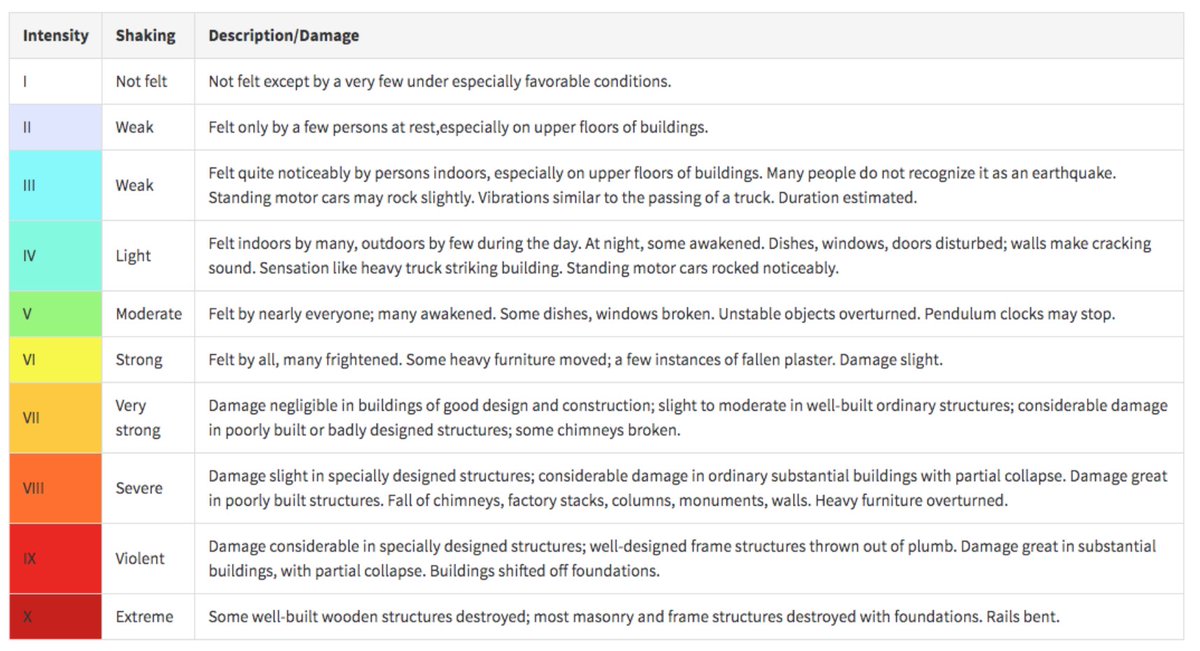
 Apps only deliver alerts to people who could feel MMI 3+ (weak shaking) or greater for quakes M4.5+ and @fema WEA alerts go to those who could feel MMI 4+ (light shaking) or greater for quakes M 5+.
 An @fema WEA Alert was distributed for this earthquake. Currently WEA alerts are only delivered for earthquakes M5 and greater and only to those who could feel light shaking (MMI 4) or greater. If this quake was only M 4.9 why was a WEA delivered?

 Light shaking (MMI 4) was outside of California so no @fema WEA ShakeAlert was distributed - see color scale for comparison. Even though this earthquake was outside the seismic network and harder to locate #ShakeAlert performed well. (2/5)
 This animation shows what might happen in a future scenario of a magnitude 7.0 earthquake hitting the region. Pay attention to how the strongest waves (reddish hue) propagate away from the epicenter. Notice how they race toward the south? (2/4)
 We had representatives from a variety of sectors including health care, academia, city government, entertainment, and transportation. Thanks to all who have participated in the last three workshops. @CaltechSeismo
 Take a look at the #ShakeAlert Post-Alert Summary.