Philippe Papin Profile picture
Hurricane Specialist at @NWSNHC | Ph.D + M.S. via @UAlbanyDAES & B.S. via @UNCAweather | All kinds of weather 🌤❄️⛈🌪| Thoughts are my own |
Délcio Neitzke Profile picture 1 subscribed
Sep 1, 2022 6 tweets 4 min read
Let's discuss the anomalous NATL high latitude SST warming that occured this Summer + the negative SSTA that shifted equatorward. Remarkable seasonal changes that need an explanation.

1⃣hypothesis: The SSTA pattern was aided by enhanced NATL anticyclonic wave breaking (#AWB). We've certainly seen our fair share of #AWB events recently. These atmospheric waves break over & over in the NATL, helping define the mean tropical upper-tropospheric trough (#TUTT), individually comprised of potential vorticity streamers (#PVSs) folding under building ridges.🌊
Jun 21, 2022 6 tweets 4 min read
A June African Easterly Wave (#AEW) is getting ready to emerge off the African coast. While it is quite early in season, there are a couple of factors worth monitoring w/ this system over the next week I'll try to briefly describe --

Image source: @Weathernerds As this wave propagates westward, a convectively coupled kelvin wave (#CCKW) is propagating eastward & could result in anomalous favorable environmental conditions across the MDR as it passes across over the next week.

Image source: ncics.org/portfolio/moni…
Jun 23, 2021 4 tweets 2 min read
Given the potential historic nature of the upcoming Pacific NW heatwave, though it might be a useful exercise to trace back the antecedent synoptic pattern.

It starts w/ enhanced moisture off Asia enhancing NPAC jet, kicking off persistent ridge building over British Columbia. The "persistent" amplified ridge over British Columbia is key, b/c it takes multiple rounds of downslope mixing to boost sensible heat fluxes resulting in this heatwave.

Each successive day 850-hPa temps increase over the heat dome until max anomalies are +25C above normal!
Aug 26, 2020 5 tweets 3 min read
For this elevation (beam height from KLCH is around 16,000ft which is ~550-hPa), these radial velocities seen in the E eyewall of #Laura are incredible. Yes that is an inbound 160-mph velocity... at 550-hPa!

This is a very powerful and deep vertical circulation. 
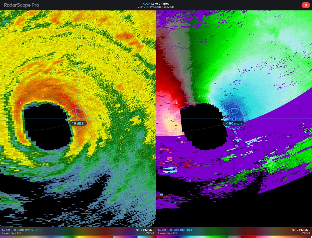
And if you go pixel hunting for the maximum velocity pixel, there are values that are larger than that too. The latest scan for example has a 169-mph pixel!

The @53rdWRS normally samples strong hurricanes at 700-hPa as winds decrease w/ height. This is well above that level!
Oct 30, 2019 5 tweets 4 min read
It's been a hard week for CA w/ major wildfires (#GettyFire, #KincaidFire) affecting the state.

Synoptic weather context is key: Fires were aided by repeated mountain & gap winds via ridge building over the Great Basin. This ridge building enhances the pressure gradient over CA. The synoptic weather sets the stage, but the mountain interaction enhances the winds further.

Let's illustrate the mesoscale details w/ a cross-section across the coastal CA mountain ranges. Hurricane force (#SantaAna) winds form as cold easterly flow tries to cross the barrier.
Sep 2, 2019 4 tweets 2 min read
Here is the sequel to my steering flow animated explanations. I'm covering 2 periods.

1st period is when #Dorian is expected to stall.

3 Features Cancel out:
1) Ridge over the NATL
2) Ridge over the Midwest
3) Trough that creates a weakness between the two ridges. So naturally the next question is, what causes the #Dorian to start moving again?

Essentially one ridge becomes stronger (NATL ridge), while the other one weakens (Midwest US), with progressive troughs making sure the weakness stays open. Breakdown below⬇️
Aug 30, 2019 5 tweets 3 min read
Okay so while all attention is on #Dorian, let's do a quick tour of the rest of the NATL tropics currently, because there are some other systems to talk about.

There is a weak llvl circ. n/ Cuba W of Dorian. It should move into the GoM where it has a chance to organize further. Next up is an African Easterly Wave that just emerged off the coast. The model guidance has been somewhat optimistic on this wave developing over the next 5-7 days, so worth keeping an eye on it. Aside from the Cape Verde islands, no threat to land.
Aug 28, 2019 10 tweets 7 min read
1/9: Over the last 24 hours there have been large eastward shifts in #Dorian's track. It may now just clip #PuertoRico to the east! How?

Let's start with Dorian's vertical structure. One critical change is how vertically coherent Dorian's vortex has become, as seen below. 2/9: Here is another way to view it, this time from a lat-lon map. Over the last four GFS model cycles, the separation between the low & mid level centers of #Dorian decreases until they are on top of each other.

Correspondingly the low-level vortex migrates to the northeast.
Aug 13, 2019 10 tweets 8 min read
Last Wednesday (08-07-19), I flew on the @NASA DC8 for the first time, when the plane sampled the #WilliamsFlatsFire for #FIREXAQ. We sampled the fire for 3 hours (5pm-8pm PT) making 10+ passes into smoke & pyrocumulus.

This thread is a sample of photos I took on the flight. Image 
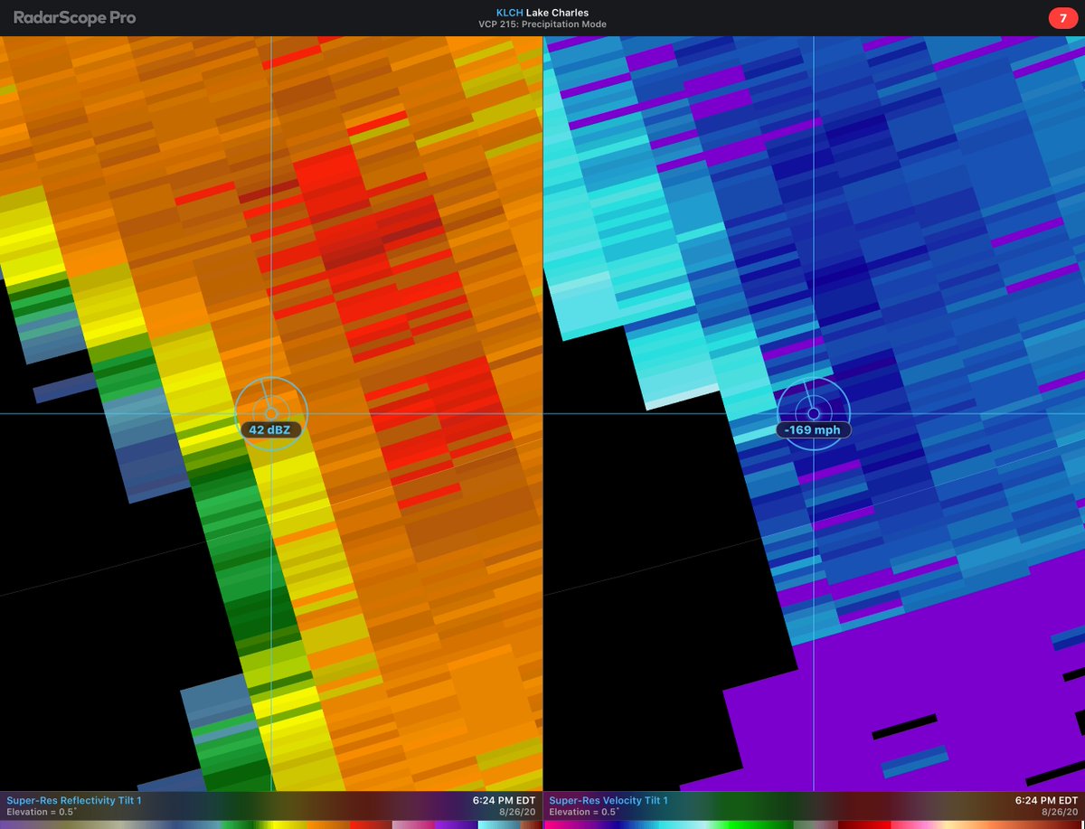
@NASA We first did an east-to-west longways pass over the smoke & Pyrocumulus (#PyroCu) cloud around 5pm PT. This photo suggests that the PyroCu updrafts are lofting smoke well above the boundary layer.

You can also see the Columbia River in the right part of the photo. Image
Jul 11, 2019 6 tweets 3 min read
1) Now that #Barry has formed in the Gulf of Mexico, let's talk about how the forecast has evolved from a few days ago.

First, it appears the GFS handled Barry's initial structure better, with a low-level circulation removed from the mid-level vortex. 2) This is a result of continued northerly shear & dry air advection, which is both from the upper-level ridge poleward of Barry & also a dangling PV Streamer which folded under the ridge off the eastern coast.
Sep 11, 2018 9 tweets 7 min read
1) Let's reason out why the #GFS tracks #Florence NE of the #ECWMF even now 3 days till verification? Look at the upper-level cirrus canopy b/c cloud-radiative feedback is important.

The #GFS has a thicker & more expansive cirrus plume NW of #Florence. What is its significance? 
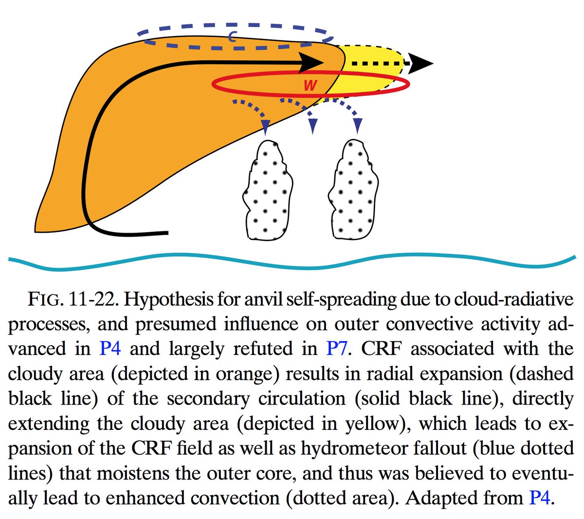
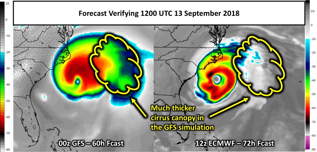
2) The cirrus in a #TCs outer core enables cloud-radiative feedback, w/ lw warming under & lw cooling above clouds.

Warming under clouds enhances convective activity in the outer core, broadening the tangential wind field.

Fig. from Fovell et al. (2016) :journals.ametsoc.org/doi/10.1175/AM…