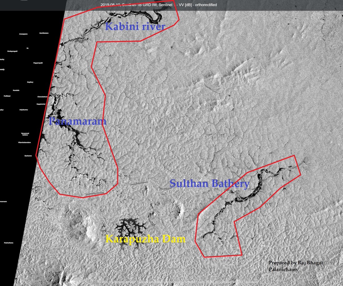
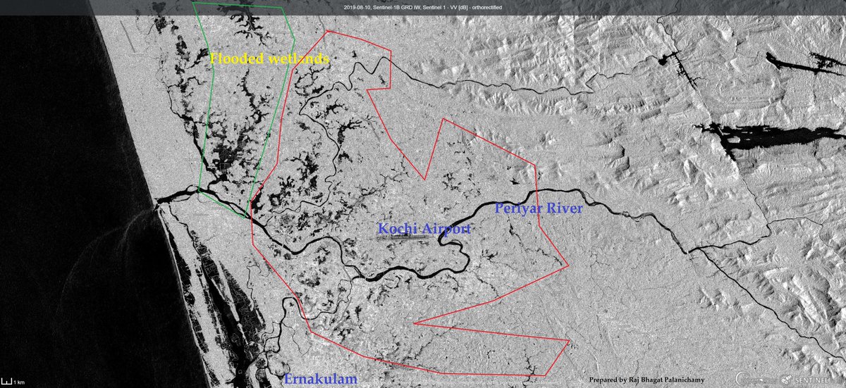
Keep Current with Raj Bhagat P #Mapper4Life

Raj Bhagat P #Mapper4Life Profile picture

Stay in touch and get notified when new unrolls are available from this author!

Read all threads

This Thread may be Removed Anytime!

PDF

Twitter may remove this content at anytime! Save it as PDF for later use!

Try unrolling a thread yourself!

how to unroll video
  1. Follow @ThreadReaderApp to mention us!

  2. From a Twitter thread mention us with a keyword "unroll"
@threadreaderapp unroll

Practice here first or read more on our help page!

More from @rajbhagatt

Aug 24
Google maps shows my GPS position to be well inside the sea in #Chennai Marina beach. But I was away from it. Why?

#Thread continuation of my previous one on Chennai #Marina beach
1/n
Image
Image
In the previous thread, I had explained how Marina beach is growing (sea becoming more and more land). Because of the longshore drift, lots of sand hence gets settled in the mouths of Cooum River. Image
To prevent further siltation in the mouth of the river, the government had built Groynes so that the capacity of the river doesn't get reduced. Image
Read 15 tweets
Aug 16
#Thread
#Marina beach is one of the most iconic destinations in Chennai and one of the most visited beaches in the world. However the beach as we see today didn't exist a century ago.

This thread explains the formation of #Chennai's Marina beach
1/n Image
This map below shows the approximate original coastline of Chennai during British era. It was much closer to the Kamarajar road. A promenade was developed during the british era and that is when it got the name, "Marina". However the big sandy expanse itself didnt exist
2/n Image
Seas are very dynamic in nature. Whenever the waves hit the beach which is called as "swash", they bring in sand and when the water goes back ("backwash"), it removes the sand. This balance is critical for beach existence.
Read 24 tweets
Jul 30
#Thread of #Maps that can help understand the #WayanadLandslide incident, its causes & impact

Please note that all the maps below were created with the information available as of now. Some of the damages outside the areas denoted might have been missed as info keeps coming Image
1. This part of #Wayanad is within the Chaliyar river system. It is a west flowing river which drains into the laccadive sea on Kerala coast (though at this part it is north and east flowing)

This map shows where the water drains. The area that is affected is shown in red. Image
2. In this particular section, the stream arises at around 2000 metres above mean sea level and has a steep fall of around 1200 m to reach Vellarmala, Chooralmala section. Image
Read 8 tweets
Jun 1
#Thread
A collection of geographical myths & unknown facts about #Kanyakumari

1. Kanniyakumari is NOT the southern most point of mainland India, the southern most point is near star of the sea rock in nearby #Kovalam. In the last 20 years,it has been popularized as sunset point Image
2. Contrary to popular opinion, the three seas (Arabic Sea, Bay of Bengal, Indian Ocean) don't meet in Kanniyakumari.

Officially, the sea around Kanniyakumari district is Laccadive sea. Check map below for official extents of the seas and their names Image
3. Before 1956, Kanniyakumari was part of Travancore which pre-independence was a separate princely state. The South Travancore lines (a series of fortifications) were built to protect #Travancore. Currently, a small amount of this fortification is visible near Kanniyakumari
Image
Image
Read 7 tweets
Feb 25
Here's a compilation of my #maps which can help you in understanding the #Bengaluru #Water situation a bit better.

Bengaluru is unofficially a hill station which is located nearly a kilometre above sea level. Image
Being in the top of a ridge line, the city is partly within Kaveri watershed and partly in Ponnaiyar (Dakshina Pinakini watershed).
Being on top, water from elsewhere dont flow through Bengaluru but flow outward from the city
Image
Image
Bengaluru right now depends on Kaveri river for water supply. Because of its height, Water is pumped for a height of 1000 feet from the river 100km away from the city Image
Read 15 tweets
Feb 4
Here is the story of how @googlemaps helped me recover items stolen in a moving train from my father.

My father was travelling from Nagercoil to Trichy in sleper class in Nagercoil - Kacheguda express. He had boarded at 1:43 AM from NCJ. The train was relatively empty & another person who boarded along with my dad stole my dad's bag and mobile phone from him, and deboarded the train in Tirunelveli Junction.Image
When my dad realized it, he searched in the train and rang me from his friend's phone at 3:51 AM to inform that his phone was stolen. Luckily, among immediate family members we have location sharing "on" which meant I could track the location of mobile. When I checked it, I realized that the mobile was moving along the track near Melapalayam in Tirunelveli so I deduced that the thief was returning back to Nagercoil in another train.Image
I called my close friend Babin who is also a local DMK (@arivalayam) functionary to help me recover this. And we both went to Nagercoil station to catch the theif. The railway police listened to us and one of them came along. This is a snapshot of Google maps at the time when I was waiting railway station and the theif was still having my dad's phone.Image
Read 8 tweets

Did Thread Reader help you today?

Support us! We are indie developers!


This site is made by just two indie developers on a laptop doing marketing, support and development! Read more about the story.

Become a Premium Member ($3/month or $30/year) and get exclusive features!

Become Premium

Don't want to be a Premium member but still want to support us?

Make a small donation by buying us coffee ($5) or help with server cost ($10)

Donate via Paypal

Or Donate anonymously using crypto!

Ethereum

0xfe58350B80634f60Fa6Dc149a72b4DFbc17D341E copy

Bitcoin

3ATGMxNzCUFzxpMCHL5sWSt4DVtS8UqXpi copy

Thank you for your support!

Follow Us!

:(