1/2 Morgenochtend om 5:50 NL tijd lanceert @SpaceX het #DRAGON CRS-20 bevoorradingsschip naar het #ISS. Als de lancering doorgaat en het helder is, is ze 20 minuten later, rond 6:12 NL tijd in de ochtendschemering, vanuit ons land te zien. Kaartje onder is voor Leiden.
3/3 Er is een kans dat de CRS-20 lancering uitgesteld wordt (hoge windsnelheden op dit moment ). Voor ons land zou een dag uitstel niet ongunstig zijn, ze zou dan overkomen terwijl het nog iets donkerder is.
4/4 NB: hou rekening met een onzekerheid van 1-2 minuten in het overkomsttijdstip!
• • •
Missing some Tweet in this thread? You can try to
force a refresh
So, I did some simulations with GMAT.
Assumptions:
- For totally arbitrary drag area of 1 m^2;
- Near-orbital speed at disintegration;
- disintegration at 148 km;
labels are mass in kg of fragment.
@planet4589 @DJSnM @Ian_Benecken
2/x additional info: no mass loss due to ablation upon reentry (this is important: if they do loose mass 9and they will), they come down earlier than in the map)
3/x Nevertheless: they appear to be surviving a lot further downrange than I actually had anticipated.
1/x The very successful @AETUDelft-built 3U cubesat Delfi-C3, launched 15 yrs ago, is near the end of its life. It will probably reenter into the atmosphere next month.
Yesterday evening, I managed to image it with my tracking camera from Leiden, the Netherlands:
2/x Here is the video footage (it is very faint, being a 3U cubesat, i.e. 10 x 10 x 30 cm large). Footage was shot at 25 fps with a WATEC 902H2 Supreme and Samyang 2.0/135 mm lens.
3/x Over the past months, the cubesat has been coming down increasingly fast. Currently it is in a 351 x 365 km orbit (when launched in 2008, it was at 615 x 635 km)
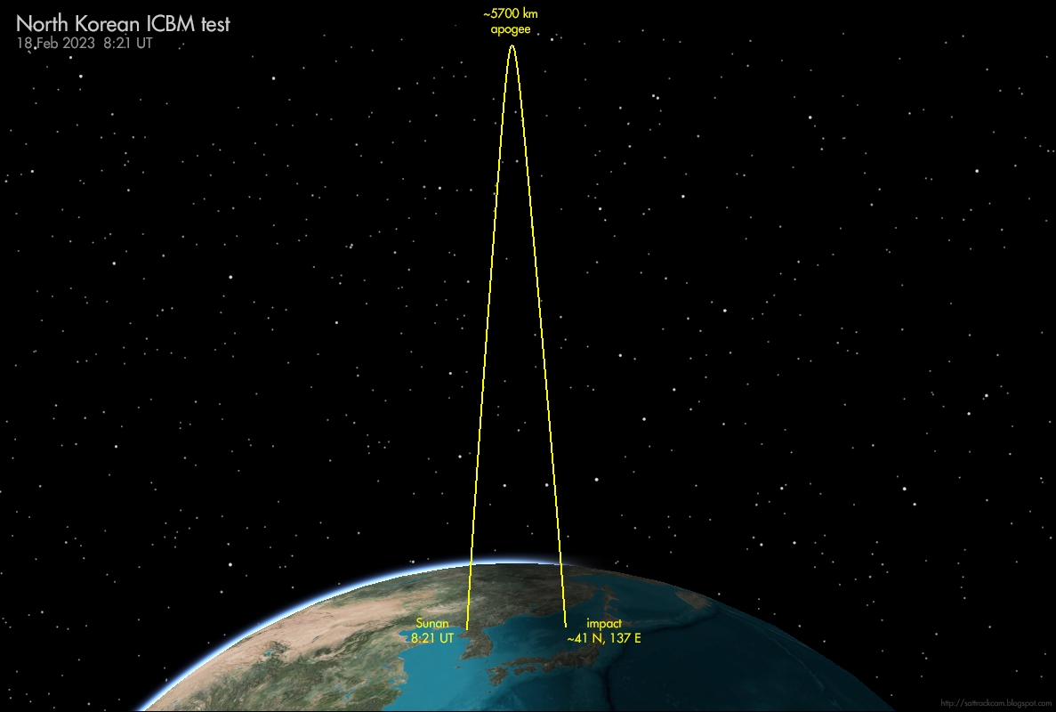
Approximate trajectory flown by the #ICBM that #NorthKorea tested today. A highly lofted trajectory.
(reconstruction based on Japanese DoD info).
When launched on a 'normal', non-lofted trajectory, the range would be 18000+ km, i.e. capable of reaching any place on Earth
Trajectory is based on rough information on apogee, range, and map with approximate impact point provided by Japanese DoD here: mod.go.jp/j/press/news/2…
It will be interesting to see what missile it concerns when Northg Korea publishes their propaganda photo's. Hwasong-17? Something new?
USA 326 (2022-009A) was launched on February 2 this year and is believed to be a new generation of electro-optical reconnaissance satellite: sattrackcam.blogspot.com/2022/02/the-up…
It is in a 97.4 deg inclined, 518 x 488 km orbit.
The Russian launch today was indeed at 20:25 UTC, right at the moment the USA 326 orbital plane passed over Plesetsk (i.e. the launch was into the orbital plane of USA 326): interfax.ru/russia/854824
2/x To be clear (as such suggestions always arrise):
This has *nothing* to do with the Ukraine crisis. Tests like these are scheduled months in advance.
They are regular tests to ascertain the readiness and training of missile crews.
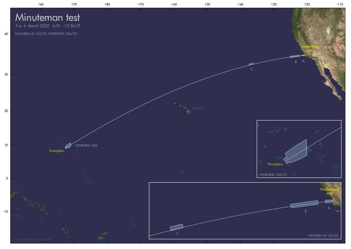
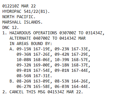
3/x As I expected, another Navigational Warning has appeared, adding an extra hazard area west of Kwajalein.
Updated map for this upcoming #Minuteman III test (probably GT240GM):
2/x ...maar worden echt in een baan om de aarde gebracht, zoals een satelliet. Waarna op een gegeven moment met een deorbit burn door een retroraket, de lading weer omlaag wordt gebracht, boven het doelwit.
Welnu: waarom zou je dit zo doen in plaats van een normale ICBM lanceren?
3/x Het voordeel van FOBS is dat het je toestaat toe te slaan vanuit richtingen die met gewone ICBM's niet worden verwacht. Via een traject over de zuidpool bijvoorbeeld. Dan benader je de VS (het doelwit) vanuit het zuiden (gele lijn), terwijl