Demonstrators shot at by security forces today in the town of #Tinzaouten (تين زاوتين) on the border of #Mali and #Algeria. Screenshots geolocated to this intersection in the west-side of the town, here: goo.gl/maps/KoyXpJjwi…
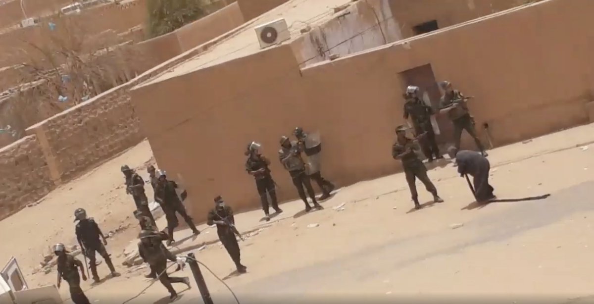
Footage below shows this intersection: goo.gl/maps/oH36p4gbM… in Tinzaouten, #Algeria. At least one civilian on the ground, not moving.
Footage of reinforcement security forces - more gunshots heard. Same intersection here: goo.gl/maps/tFVwXar9q… next to مسجد مولاي المرتجي mosque.
Photos posted from Tinzaouten (تين زاوتين) claim live ammunition was used against protestors. H/T @mohamedzitout for 📸
More security present and tighter borders between Mali/Algeria given recent conflict with AQ in the area. NOTE: close to Tinzaouten was where French operation killing AQIM leader Abdelmalek #Droukdel earlier this month:
#Tinzaouten's double-layer barbed wire wall appears to have been destroyed subsequent to the protests. This acted as a perimeter between the town and the #Algeria/#Mali border. These are screenshots of local footage, geolocated to here: goo.gl/maps/HZ2NuA9gp…
In June 15 protests in #Tinzaouten (تين زاوتين) on border of #Mali and #Algeria footage from alt. angle shows young male that was shot. Protestors attempted to assist but were pushed back by Algerian security forces. Male subsequently died. Body was here: goo.gl/maps/bZywfwWMr…
• • •
Missing some Tweet in this thread? You can try to
force a refresh
In April, CNN journalists were led to the 'home' of Haitian gang lord Vitel’homme Innocent and interviewed him. He is on @FBIMostWanted's Top 10, with a bounty of up to $2 million.
I mapped their drive and found his home here: 18.5278, -72.2314. Here's how👇🧵
First, I did this because knowing the location of where a gang lord responsible for horrible violence is helpful, even if he might not be there after CNN visited. Vitel is the leader of Kraze Barye and is on the @FBIMostWanted list for taking hostages, and sanctioned by UN.
This is the footage I used to geolocate Vitel'Homme Innocent's house, where the interview was conducted. I'll go through some of the scenes to provide proofs of how I made the geographical matches, using Google Earth.
Google Earth has updated the whole of Sudan's El Geneina to reveal the disturbing scale of damage which happened during a reported ethnic cleansing campaign over the past year by the RSF and allied militias. Images shows #elgeneina from 2022 & 2024. More in the thread below 👇
Looking at the destruction visible on Google Earth, it's clear there were large areas targeted in El Geneina's west and east. It's worth noting that some of the shaded areas in the east had remainders of where there was previous destruction from clashes prior to 2023.
The destruction can be clearly seen in this area on Google Earth, just west of the centre of Darfur's El Geneina. The comparison is of Oct 2022 and April 2024. This satellite imagery is just a visualisation of the horrors that were committed by the RSF in its campaign.
The situation in the Darfur city El Fasher (الفاشر) is extremely concerning. It's the last city not under control by the dangerous Rapid Support Forces and has been a safe haven for those fleeing attacks by the RSF.
It is now a city under siege and in a grave situation. /1
According to @MSF, a paediatric hospital in El Fasher was damaged due to the ongoing fighting. MSF ground staff reported a Sudanese Armed Forces air strike exploded nearby causing the damage. Two children died in the ICU. /2
An update on Sudan's El Fasher from @MSF on May 15 indicated that since fighting began on May 10, 454 casualties had arrived at South Hospital in El Fasher. It was reported that 56 died, but that the wounded and death toll would be higher. /3 msf.org/sudan-nowhere-…
Google Earth has updated its satellite imagery of many parts of Sudan. Looking over West Darfur city of El Geneina, I am shocked at the level of destruction. In some parts, whole areas have been destroyed and cleared. Location: 13.4469, 22.4151 (dates: April 2023 & March 2024)
The burn damage around El Geneina's specialised hospital is incredible.
It's not just the widespread burning of structures that we see in El Geneina, as a result of the ongoing violence in Sudan, but there are also clear indications of structures that have been removed, like these warehouses, located at 13.43324, 22.41364
This video, reportedly showing an Israeli woman kidnapped, beaten and taken into Gaza, was filmed from Al Shuja-iyyah St in Gaza at about 10am this morning.
Verification of the location can be confirmed through the location of the minaret in the background, white dome in the near ground, and then the angle of the orange roof in comparison to the street.
Location: 31.503462, 34.466569.
Shadows seen in the footage, indicate that the sun had to have been at a position to cast those shadows in line, or just off, the same angle as the street at 10am, or just before 10am.
Lots of smoke rising over the skyline of Khartoum today as clashes continue between RSF and SAF forces in different areas of the city.
People in Sudan have shared these flyers in a plea for help over what's happening with a water purification plant that services a lot of Khartoum with clean water.
It has been badly damaged and safe access needs to be granted to allow for repairs to be made to the plant.
The water treatment plant in Bahri appears to have been damaged in the initial wave of bombings in Khartoum. In satellite imagery on Google Earth from April 15 we can see a fire in the area, imagery from @planet on April 19 published by @hrw at least one building damaged.