Sound the sad trombone snow lovers, we've lowered predicted totals slightly one more time. Wednesday's storm will be a mess. Detailed briefing: wapo.st/3akwBfX (1/x)
Huge range in conditions from east to west in DC region Wednesday. Flood watch east of I95 for 1-2" of rain. Winter storm warning for I81 for 6-12"+ snow. (2/x)
Between the heavy rain (east of I95) and heavy snow (near I81), a swath of freezing rain is possible, with some icing possible west of I95, esp west and north of the Beltway. Here's a model forecast of freezing rain. (3/x)
Because temps will be close to 32 when freezing rain is falling, it may not accumulate that well, BUT some of our colder areas west of the city may see glazed trees and slick untreated road surfaces late Wednesday afternoon and night. (4/x)
We think the European model has a relatively good handle on the storm track and evolution. Right around DC, we may have a brief period of snow as Wed storm begins and ends with rain and freezing rain in the middle. Total snow a coating to a couple inches. (5/5)

• • •

Missing some Tweet in this thread? You can try to force a refresh
 

Keep Current with Capital Weather Gang

Capital Weather Gang Profile picture

Stay in touch and get notified when new unrolls are available from this author!

Read all threads

This Thread may be Removed Anytime!

PDF

Twitter may remove this content at anytime! Save it as PDF for later use!

Try unrolling a thread yourself!

how to unroll video
  1. Follow @ThreadReaderApp to mention us!

  2. From a Twitter thread mention us with a keyword "unroll"
@threadreaderapp unroll

Practice here first or read more on our help page!

More from @capitalweather

30 Sep
A historic and devastating onslaught of wildfires has ravaged the West since mid-August. @NASAEarth satellite imagery has captured the punishing blazes which have devoured over 3.9 million acres in California alone.

Details: wapo.st/36mOloW (1/x)
Here's the view of the Creek Fire which exploded NE of Fresno Sep. 4-5 (2/x)
This is the horrific eruption of blazes in the Pacific Northwest Sept. 7-8:
Read 5 tweets
24 Sep
Extreme cold East/warm West jet stream pattern to set up next week. Core of the cold to initially focus west of the Appalachians but should make it to East Coast in 7 to 9 days. wapo.st/3cuDgmG (1/x)
Pattern is EXACTLY the opposite of what we had last year when eastern US set dozens of all-time October heat records, including DC which was 98F. NWS calling for moderate to high risk of much below normal temps Oct 1-7 this year. (2/x) Image
If you love fall, colors are already starting to pop in the mountains of New England & northern parts of Upper Midwest and this cool weather will bring them out farther south and at lower elevations. (Map from smokymountains.com) (3/x) Image
Read 4 tweets
11 Sep
The air quality along the West Coast is the worst on the planet, due to wildfire smoke, and it's not even close. Many areas with code purple and amber air quality levels, signifying very unhealthy and hazardous pollution. Image
Zoomed-in look at air quality levels from central California through Washington, via airnow.gov. They are awful: Image
Read 4 tweets
1 Sep
Residents of SW Louisiana navigating minefield of hazards:
* #HurricaneLaura aftermath with 250K w/o electricity, over 100K w/o water
* Punishing heat/humidity...heat index values 105-109 today
* Coronavirus pandemic
wapo.st/3gPPSVS (1/x)
Several parishes in SW Louisiana still almost entirely without power, including Calcasieu Parish - home to Lake Charles - amid the relentless heat. “It’s terrible right now. I’m on my third shirt today," said resident. (2/x) Image
Generators are hard to find, expensive, and dangerous if improperly installed. 8 people have died from carbon monoxide poisoning in Louisiana since Laura struck. (3/x)
Read 5 tweets
21 Aug
[THREAD] The prospect of 2 hurricanes hitting land only a few hundred miles from one another in the Gulf of Mexico next wk is real, alarming, and very 2020. Preparing early for this possibility is key. BUT 1/4
washingtonpost.com/weather/2020/0…
T.S. Laura still has many hoops to jump through before reaching the eastern Gulf, where it's more favorable for intensification. Some computer models nearly dissipate this system as it interacts with Hispaniola and other islands. 2/4
T.D. 14 is not yet TS Marco, and it too has to cross a land mass to reach the Gulf and intensify. And when it gets closer to land on Tue/Wed, it may encounter hostile atmospheric conditions that cause it to weaken. 3/4
Read 4 tweets
3 Aug
#Isaias and DC-MD-VA! Short thread...
* Tropical storm and flash flood watch out for large parts of the region
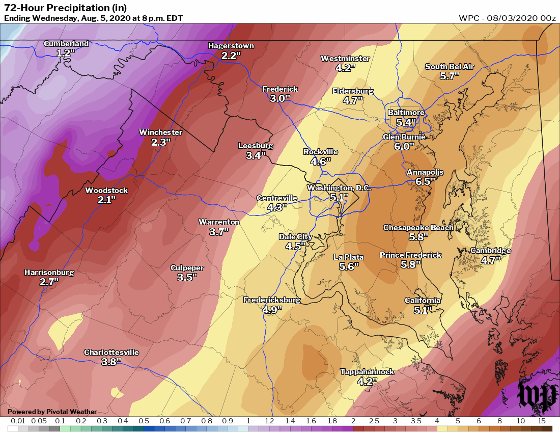
* High confidence in heavy rain. NWS has INCREASED our rain forecast to 4-6" along I-95 corridor, 2-4" to west, 5 to 7" east. (1/x) Image
Heaviest rain from #Isaias in DMV expected Mon night to Tues evening.

Strongest winds forecast Tuesday afternoon - esp in the afternoon as core of storm comes closes. Expect strongest winds (30-55 mph gusts) EAST of I-95 near Bay and Delmarva unless storm shifts west. (2/x) Image
Models pretty consistent forecasting #Isaias to track east of DC. But rain & winds will expand as it merges with stalled front & is captured by jet stream.
In unlikely event storm takes more western route, would increase chance of tropical storm winds in immediate DC area. (3/x) Image
Read 4 tweets

Did Thread Reader help you today?

Support us! We are indie developers!


This site is made by just two indie developers on a laptop doing marketing, support and development! Read more about the story.

Become a Premium Member ($3/month or $30/year) and get exclusive features!

Become Premium

Too expensive? Make a small donation by buying us coffee ($5) or help with server cost ($10)

Donate via Paypal Become our Patreon

Thank you for your support!

Follow Us on Twitter!