Sunday evening #sNOw update:
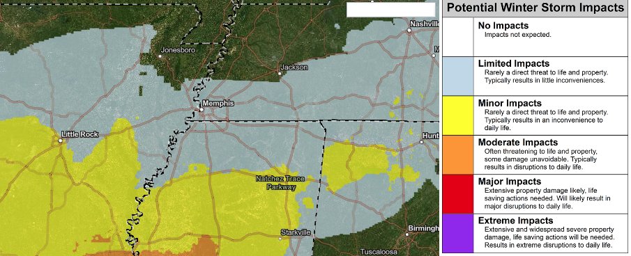
Continuing the trend from this morning, today's model data has not been encouraging for snow lovers. In fact with high-res (3km hourly) model data now within range, the path for snow accumulation seems to now be south of the metro in north/central MS.
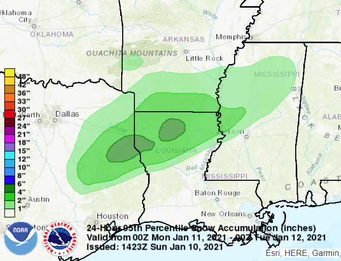
The main culprit for this southward shift is the further intrusion of dry air into the I-40 corridor, as mentioned could happen in Saturday's blog. Here's the NAM3 model showing moisture anomaly (green is not rain, but above normal moisture where accumulation is most likely).
Bottom line: some light snow or flurries are possible in the metro from around dawn until lunchtime, but I would be surprised to see accumulation, other than a dusting on exposed objects/bare ground in the immediate metro. Winter is not over. Don't lose hope. #memsNOw

• • •

Missing some Tweet in this thread? You can try to force a refresh
 

Keep Current with MemphisWeather.net

MemphisWeather.net Profile picture

Stay in touch and get notified when new unrolls are available from this author!

Read all threads

This Thread may be Removed Anytime!

PDF

Twitter may remove this content at anytime! Save it as PDF for later use!

Try unrolling a thread yourself!

how to unroll video
  1. Follow @ThreadReaderApp to mention us!

  2. From a Twitter thread mention us with a keyword "unroll"
@threadreaderapp unroll

Practice here first or read more on our help page!

More from @memphisweather1

10 Jan
Sunday AM Snow Update: latest models continue to show minor amounts (1/2" or less) of snow on Monday.

When? Dawn-ish through early afternoon. Temps: 31-36.

NWS impact forecast has lowered from "minor" to "limited" impacts. #memsnow
Overnight and early AM models/ensembles range from 0.1"-0.8", almost all < 0.5". Highest chances for more than this are SOUTH of the metro (central MS could get 1-2"). Less to our north. #memsnow
Here's the probability of 1"+ of snow with 95% confidence (meaning there's only a 5% chance of 1" outside of the lightest green). Notice the metro is not within this area. Doesn't mean we won't get a dusting or light accumulation, but 1" is highly unlikely. #memsnow
Read 5 tweets

Did Thread Reader help you today?

Support us! We are indie developers!


This site is made by just two indie developers on a laptop doing marketing, support and development! Read more about the story.

Become a Premium Member ($3/month or $30/year) and get exclusive features!

Become Premium

Too expensive? Make a small donation by buying us coffee ($5) or help with server cost ($10)

Donate via Paypal Become our Patreon

Thank you for your support!

Follow Us on Twitter!