Sure, it's chilly out there, but it'll get colder. Here's a hand drawn map over a satellite image taken from the NOAA 20 polar orbiting satellite today. A weak system moving south through B.C. with a give a modified arctic front a shove southward tomorrow.
That's the precursor to more interesting weather later Thursday into Saturday. Outflow finds through the Fraser River Valley will increase substantially by Thursday - which provides Western WA with additional (and colder) air.
Moisture arriving from our southwest on Thursday will "overrun" the cold air in place - and that's the final ingredient for snow. On a side note, the yellow arrows point to "cloud streets" formed by the chilly air escaping B.C.'s interior.
Details regarding a possible range of snow amounts for a number of locations in Western Washington will be posted shortly. #wawx

• • •

Missing some Tweet in this thread? You can try to force a refresh
 

Keep Current with NWS Seattle

NWS Seattle Profile picture

Stay in touch and get notified when new unrolls are available from this author!

Read all threads

This Thread may be Removed Anytime!

PDF

Twitter may remove this content at anytime! Save it as PDF for later use!

Try unrolling a thread yourself!

how to unroll video
  1. Follow @ThreadReaderApp to mention us!

  2. From a Twitter thread mention us with a keyword "unroll"
@threadreaderapp unroll

Practice here first or read more on our help page!

More from @NWSSeattle

10 Feb
Another round of morning thoughts from the forecast desk:

- A modified arctic front will lead to a few snow showers mainly north of Seattle today.
- The front will bring cold, but increasingly drier air to much of the region on Thursday.
- The weather system on Thursday will be battling this very dry air.
- Because of this dry air in place, we expect the best snowfall accumulation potential Thursday afternoon and night will be south of Tacoma.
- This won't be a "one and done" situation.
- Another weather system arrives Fri night & Saturday A.M. This one has greater snowfall potential across a larger portion of Western WA.
- There is still some considerable uncertainty on amounts.
- Saturday's system is less a question of "Will it snow?", but rather "How much?"
Read 4 tweets
10 Feb
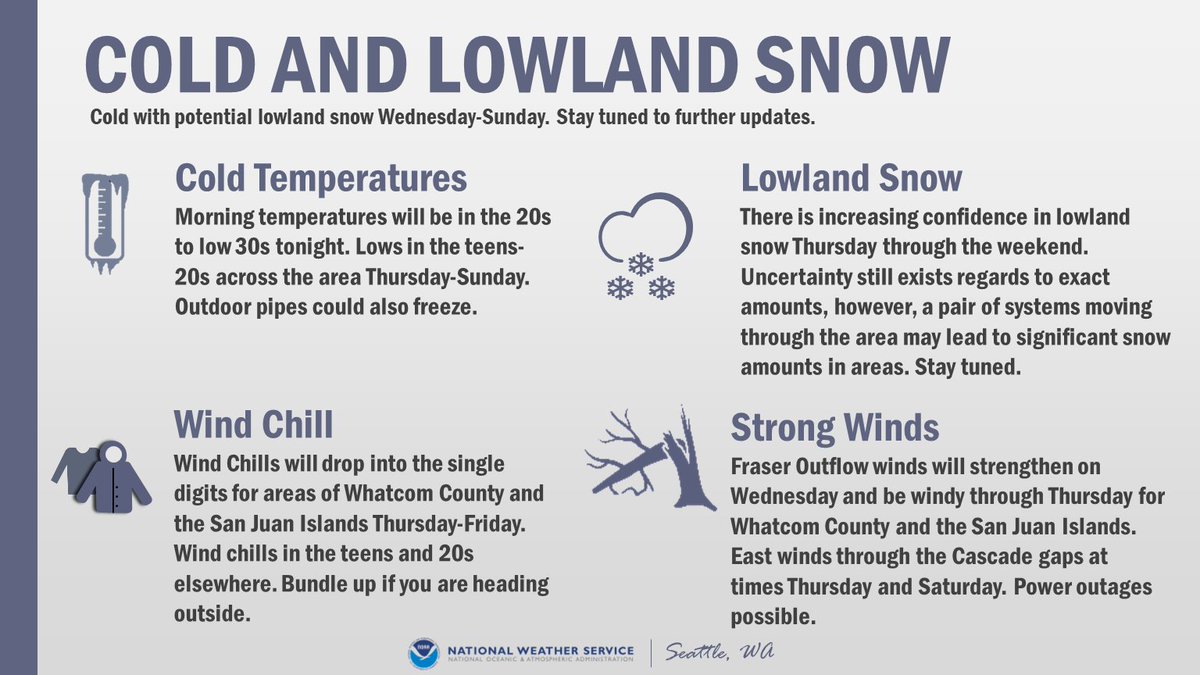
Alright everyone, let's discuss the active weather pattern for this week. Here are the main areas of focus:

🌨️Lowland Snow
🥶Cold Temperatures & Wind Chill
🌬️Locally Strong Winds Morning temperatures will be in the 20s to low 30s tonight.
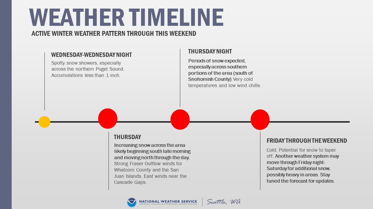
The active weather pattern is expected from Wednesday through the weekend. Spotty snow showers Wednesday, with increasing snow Thursday morning. The potential exists for another round of snow Friday night into the weekend. However, there is uncertainty in the forecast. #WAwx
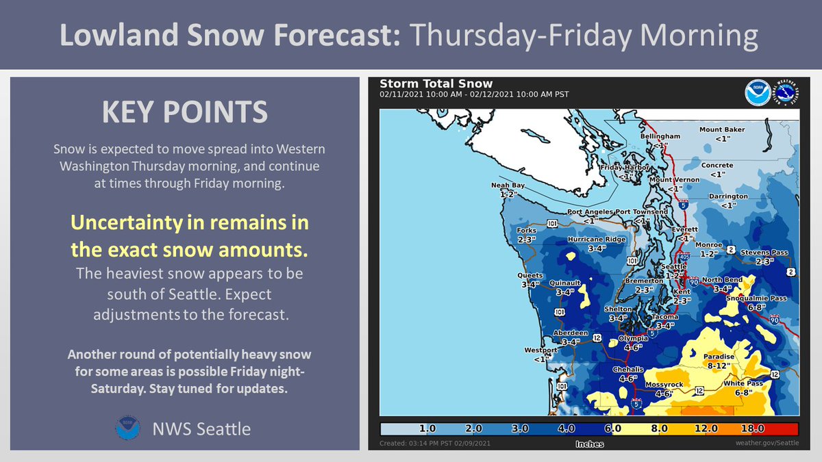
First call snow map for Thursday-Friday Morning:

Confidence is increasing in lowland snow for Thursday-Friday morning. Expect some adjustment to these snow amounts as we approach the event. Another round of snow potentially Friday night into the weekend. #WAwx
Read 7 tweets
7 Feb
[🥶THREAD] We hit on snow in a thread earlier so now let's talk COLD! Much colder air is on the way for the rest of the weekend with the coldest temperatures mid to late week. Overnight lows will likely drop below freezing, into the teens and 20s for many locations. #wawx
While we're confident it'll be some of the coldest air we've seen this winter, this is still uncertainty in just how low temperatures may drop! Here's a look at the ranges we might see by Friday morning! #wawx Image
In addition to the cold - gusty northeast winds from the Fraser River Valley near the Canadian border are expected to flow into western Whatcom, Skagit, and the San Juans. Need a refresher on Fraser Outflow? Check out this video: #wawx
Read 6 tweets
7 Feb
[THREAD] First up for our afternoon forecast updates is the lowland snow potential! We'll post another thread with info on the cold later so it's easier to keep it all straight! 🥶 #wawx
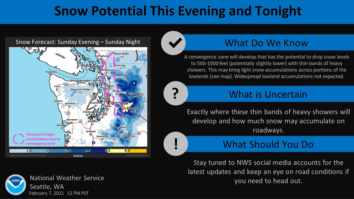
A convergence zone will develop this evening - tonight that has the potential to drop snow levels to 500-1000 feet (potentially slightly lower) with thin bands of heavy showers. This may bring light snow accumulations across portions of the lowlands - see graphic. #wawx Image
So what's still uncertain?
❄️Exactly where these thin bands of heavy showers will develop
AND
❄️How much snow may accumulate on roadways given above freezing temperatures
We'll certainly have frequent updates here as things develop so stay tuned! #wawx
Read 5 tweets
11 Jan
We've got a lot weather-wise coming our way into Wednesday. So how about a quick thread with the details to kick off the work week? Rain, Flooding, Landslides, Snow, Wind, & Coastal Hazards - we've got it all! Keep it tuned here throughout the storm! #wawx
Rain is moving onshore this morning & will continue at times thru Weds. Heaviest tonight - Tues AM & again Tues night - Weds AM. Snow levels will rise. This brings about the potential for urban, small stream, & river flooding. The threat for landslides returns as well. #wawx
Speaking of snow levels - warmer air will invade, rising snow levels above the passes Tuesday. But not before the storm drops some snow at pass level! If you have travel plans over the Cascades, give @wsdot a follow and check road conditions at: wsdot.com/traffic/passes #wawx
Read 6 tweets
21 Sep 20
Well it looks like fall is going to waste no time making its presence known! A weather system will bring widespread rain - heavy in spots - and wind to the area Wednesday with showers continuing through at least Friday! Here's a short thread with the details! #wawx Image
Wondering how much rain we'll see on Wednesday through early Thursday? Take a look at our latest forecast! Additional rain (not depicted here) expected for the end of the week with isolated thunderstorms also a possibility Thursday & Friday. #wawx Image
Along with the rain, Wednesday's system will also bring some gusty winds with it. Highest winds expected along the coast. Localized power outages & tree damage possible as trees still have most of their leaves on! #wawx Image
Read 4 tweets

Did Thread Reader help you today?

Support us! We are indie developers!


This site is made by just two indie developers on a laptop doing marketing, support and development! Read more about the story.

Become a Premium Member ($3/month or $30/year) and get exclusive features!

Become Premium

Too expensive? Make a small donation by buying us coffee ($5) or help with server cost ($10)

Donate via Paypal Become our Patreon

Thank you for your support!

Follow Us on Twitter!