Two large earthquakes have occurred beneath the southwest Pacific today. The earlier M7.3 was strongly felt across much of New Zealand. The more recent M7.4 occurred ~4 hr later, ~900 km away. Given the large distance between them, the events are probably not directly related. 🧵 map showing earthquake epicenters for March 5 in the south P
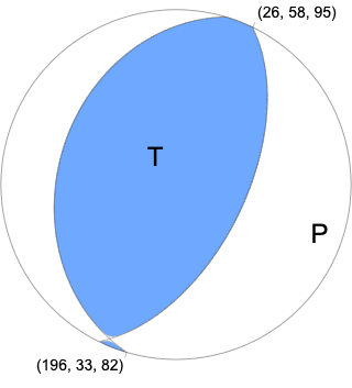
The @USGS-determined focal mechanism and origin location for the earlier M7.3 near New Zealand suggest that the earthquake resulted from complex faulting within the subducting Pacific Plate. earthquake.usgs.gov/earthquakes/ev…
@USGS The M7.4 much farther north along the Kermadec Trench has a focal mechanism and origin depth consistent with slip along the subduction interface between the Pacific and Australia Plates. earthquake.usgs.gov/earthquakes/ev…
@USGS You may be asking, “are these related?” Well, stress changes from earthquakes typically extend only up to about 3 rupture-lengths away, and these earthquakes are more like 10 rupture lengths apart! They’re unlikely to be related—large earthquakes in this region are common.
@USGS The latest (third) large earthquake--a M8.1-- *is* directly related to the M7.4 in nearly the same location just under 2 hours before. Both of those occurred on the subduction interface between Pacific and Australia plates.

• • •

Missing some Tweet in this thread? You can try to force a refresh
 

Keep Current with USGS Earthquakes

USGS Earthquakes Profile picture

Stay in touch and get notified when new unrolls are available from this author!

Read all threads

This Thread may be Removed Anytime!

PDF

Twitter may remove this content at anytime! Save it as PDF for later use!

Try unrolling a thread yourself!

how to unroll video
  1. Follow @ThreadReaderApp to mention us!

  2. From a Twitter thread mention us with a keyword "unroll"
@threadreaderapp unroll

Practice here first or read more on our help page!

More from @USGS_Quakes

2 Oct 20
Yes, swarms aside, it is still Friday, and on this channel, that means #FaultFriday. To learn more about the area around the Westmorland swarm, let’s look at the Imperial fault of southern California today.
The Imperial fault is a right-lateral strike-slip fault (ow.ly/gKEq50BIfDq) that runs south of the Salton Sea, across the US-Mexico border, and into Mexico. The Imperial fault had two significant earthquakes in the 20th century, a M6.9 in 1940 and a M6.5 in 1979. Map showing Imperial fault and Westmorland Swarm in southern
Before the 1940 El Centro event, this fault probably did not have an earthquake in the previous 300 years. Geologists can literally uncover the history of past earthquakes along a fault by digging a shallow trench across a fault and observing and dating the offset layers.
Read 6 tweets
1 Oct 20
An #earthquake swarm has kicked off southwest of the #SaltonSea today, producing 240 earthquakes as of 8pm Pacific. The largest earlier this evening was M4.9.
So what does this mean? We’ve put together some scenarios to explain what could happen next. usgs.gov/center-news/ea…
The most likely scenario is that the rate of earthquakes in the swarm will decrease over the next 7 days. Some additional moderate-sized earthquakes (M4.5 to 5.4) may occur. Smaller magnitude earthquakes (M3.0+) may be felt by people close to the epicenters.
A less likely scenario is a somewhat larger earthquake could occur (up to a M6.9). Earthquakes of this size could cause damage around the area close to the swarm and would be followed by aftershocks that would increase the number of smaller earthquakes per day.
Read 7 tweets
30 Sep 20
What do subduction zones do? They do everything! They make earthquakes and volcanos and tsunamis. 😸
When one plate slides under another, it sinks into the hotter parts of the Earth and starts a melting process. The melt floats up creating a line of volcanoes (called a chain or arc) like the Cascades volcanoes in California, Oregon, and Washington. Oceanic-continental converg...Map of Cascades volcanosMount St. Helens (left) and...
The process of sliding one plate under another creates earthquakes. When this happens underwater, if the conditions are right, the vertical motion can spawn a tsunami. Stuck area ruptures, releas...
Read 6 tweets
25 Sep 20
Yes, check your calendars—today is Friday! We are happy to bring you a recurring weekly treat of #FaultFriday, where we introduce you to a different fault across the country.
For this #FaultFriday, let's visit Wyoming and check out the normal Teton fault. @WyGeoSurvey recently published a gorgeous new map of the Teton fault below: Fault map showing topograph...
New field mapping of the Teton fault, utilizing lidar data, shows the fault continues further to the north and the south than previously thought, and is a bit more complex. This GIF compares previous mapping (blue lines) to new mapping (red lines).
Read 5 tweets
21 Sep 20
Ever wonder what #EarthquakeHazard looks like for the entire US? The @USGS’s National Seismic Hazard Map (NSHM) defines the potential for earthquake ground shaking for various probability levels across the country. Image
The NSHM represents an assessment of the best available science in earthquake hazards and incorporates new findings on earthquake ground shaking, seismicity, slip-rates, frequencies of various magnitudes and long-period amplification over deep sedimentary basins.
Periodic revisions of these maps incorporate results of new research. The above, 2018 map is based on the most recent USGS models for the conterminous U.S. (2018), Hawaii (1998), and Alaska (2007).
Read 7 tweets
15 Sep 20
Reminder – September is #PreparednessMonth
Week 1: Make A Plan
Week 2: Build A Kit
Week 3 (this week!): Prepare for Disasters
Week 4: Teach Youth About Preparedness
#BeReady
ready.gov/september Image
Are you familiar with the 7 Steps to Earthquake Safety?
1 Secure your space
2 Plan to be safe
3 Organize disaster supplies
4 Minimize financial hardship
5 Drop, Cover, & Hold On
6 Improve safety
7 Reconnect & Restore
ow.ly/hPi250BrTe8
En Español: ow.ly/EYJF50BrTab
Step 4: “minimize financial hardships” is one aspect of this that includes learning about the buildings in which you and your family spend time. Are these buildings likely to stay standing and protect you during earthquake shaking? Image
Read 5 tweets

Did Thread Reader help you today?

Support us! We are indie developers!


This site is made by just two indie developers on a laptop doing marketing, support and development! Read more about the story.

Become a Premium Member ($3/month or $30/year) and get exclusive features!

Become Premium

Too expensive? Make a small donation by buying us coffee ($5) or help with server cost ($10)

Donate via Paypal Become our Patreon

Thank you for your support!

Follow Us on Twitter!