It's #DolphinDay so of course we have to share this amazing Roman mosaic of Cupid riding a dolphin from Fishbourne @romanpalace

📷 by Tony Hisgett / CC BY 2.0 Image
The palace is the largest residential Roman building discovered in Britain and has a massive number of amazing mosaics to match.

📷: Some of the wide-spanning mosaic floors, by Nigel Richardson / CC BY-SA 2.0 Image
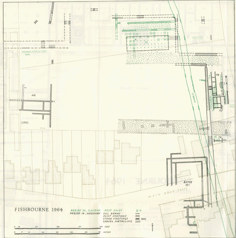
Many of the mosaics - including the delightful dolphin - were discovered during excavations in the 1960s, after a trench for a water-main exposed building material.

🔗 to the excavations being reported in Antiquity (£) doi.org/10.1017/S00035…
📷: One of the mosaics being dug up Image
📷: Another snapshot of the excavations, revealing both mosaics and parts of the buildings in the North Wing. Image
The black and white photos don't quite do the mosaics justice, but the plans produced from these excavations are 😻 ImageImage

• • •

Missing some Tweet in this thread? You can try to force a refresh
 

Keep Current with 🅰ntiquity Journal

🅰ntiquity Journal Profile picture

Stay in touch and get notified when new unrolls are available from this author!

Read all threads

This Thread may be Removed Anytime!

PDF

Twitter may remove this content at anytime! Save it as PDF for later use!

Try unrolling a thread yourself!

how to unroll video
  1. Follow @ThreadReaderApp to mention us!

  2. From a Twitter thread mention us with a keyword "unroll"
@threadreaderapp unroll

Practice here first or read more on our help page!

More from @AntiquityJ

15 Apr
🆕 #archaeology: A 'missing link' in alphabet history has been discovered, as archaeologists working in 🇮🇱 have found an ancient bit of writing that helps fill a gap in its early history.

Here's an #AntiquityThread on the find, published today (🆓) buff.ly/2Q2HTNR 1/🧵 Image
Researchers had previously found evidence of the alphabet developing in the Sinai peninsular, around 1800 BC and eventually spread to the Levant around 1300 BC. 2/

📷: An early example of the alphabet from Sinai Image
From there, it began to spread around the Mediterranean, eventually developing into the Greek and Latin alphabets. 3/

📷: A lovely bit of ancient Greek alphabet, by Marsyas / CC BY 2.5 Image
Read 17 tweets
12 Feb
🆕 #archaeology: Some of Stonehenge appears to have originally been part of a Welsh stone circle that was dismantled & moved 280 km to Salisbury Plain ~3000 BC.

Here's an #AntiquityThread on research published today in Antiquity (🆓) buff.ly/3rFcVsf 1/🧵
The discovery was made at the Waun Mawn site in the Preseli Hills of Wales, close to the quarries some of Stonehenge's bluestones came from. 2/

📷: Excavations at Waun Mawn
The researchers had previously identified that some of Stonehenge's bluestones came from those nearby quarries.

However, they found the stones were extracted before construction started at Stonehenge. 3/

📷: One of the quarries under excavation
Read 16 tweets
1 Dec 20
🆕 #archaeology: It has been suggested a devastating tsunami submerged Doggerland ~10,000 BC. However, new analysis reveals the lost landscape survived this catastrophe.

Here's an #AntiquityThread on research published today in Antiquity (🆓) buff.ly/3mpoPnV 1/ 🧵
This event, known as the Storegga tsunami, was triggered by a giant submarine landslide in the North Sea ~8,150-years-ago. Over 3200 km3 of sediment was displaced. 2/

📷: The location of the landslide, by Lamiot / CC BY-SA 3.0
The resulting gigantic waves were a catastrophic natural disaster of a scale the region has not seen since – evidence of the tsunami has been found up to 80 km inland in 🏴󠁧󠁢󠁳󠁣󠁴󠁿 3/

📷: Tsunami sediment (grey upper layer) from Maryton on the Montrose Basin 🏴󠁧󠁢󠁳󠁣󠁴󠁿 by Stozy10 / CC BY-SA 3.0
Read 15 tweets
11 Nov 20
🆕 #archaeology: A previously unknown elite Viking ritual centre - including a feast hall, cult house, and ship burial - has been found in 🇳🇴 using ground-penetrating radar.

Here's an #AntiquityThread on the find, published today in Antiquity 🆓 buff.ly/35iDY4C 1/ 🧵
The discovery was made at Gjellestad, which is is home to the Jell Mound. This is one of the largest Iron Age funerary mounds in all of Scandinavia. 2/

📷: Archaeologists carrying out GPR analysis in front of the Jell Mound
Ground-penetrating radar (GPR) was used to map features below the surface. This survey began in 2017 to determine if construction plans would put any archaeology near the Jell Mound at risk. 3/

📷: Colder archaeologists carrying out GPR analysis in front of the Jell Mound.
Read 13 tweets
29 Jun 20
This 📷 is a map of the Roman city of Falerii Novi, near Rome, produced without lifting a trowel.

Here's an #AntiquityThread on how the archaeologists did it and the incredible discoveries they made 🧵 Image
The researchers used advanced ground-penetrating radar (GPR) to do this. Like any other radar, it bounces radio waves off things and using the ‘echo’ to build a picture.

The result is a big improvement over other ways to look underground, like a magnetometer (📷) Image
Recent advances in GPR technology means it is now possible to explore larger areas in higher resolution than ever before. As a result, it is now possible to study entire ancient cities with this technology.

📷: GPR equipment at Falerri Novi Image
Read 9 tweets

Did Thread Reader help you today?

Support us! We are indie developers!


This site is made by just two indie developers on a laptop doing marketing, support and development! Read more about the story.

Become a Premium Member ($3/month or $30/year) and get exclusive features!

Become Premium

Too expensive? Make a small donation by buying us coffee ($5) or help with server cost ($10)

Donate via Paypal Become our Patreon

Thank you for your support!

Follow Us on Twitter!