
#StillwellRoad #LedoRoad #Thread
In 1942, at the height of World War II, the Japanese were sweeping through South East Asia in a conquering tide, and heading toward the eastern flank of India. The Western Powers were desperately looking for ways to recapture Burma.
1/17
In 1942, at the height of World War II, the Japanese were sweeping through South East Asia in a conquering tide, and heading toward the eastern flank of India. The Western Powers were desperately looking for ways to recapture Burma.
1/17

General Joseph Stilwell, an American aiding the Chinese army under Chiang Kai Shek, suggested the construction of a two-lane road from India to China that would snake past north and eastern Burma into Yunnan.
2/17
2/17

This project was initially proposed by the British after they prospected the Patkai Range for a road from Assam into northern Burma. It was finally initiated in 1942 after the Japanese had fully captured Burma.
3/17
3/17
With the lines of communication from India to Allied Forces in Burma, and the land route for supplies to the Chinese forces fighting the Japanese in China, both cut, the strategic situation had become critical.
4/17
4/17
The topography of the Indo-Burma border consisted of very difficult terrain, with thick, inaccessible, and malaria infested forests. The only remaining route for supplies into China was by air, flying a roundabout route over the eastern Himalayas, called 'The Hump'.
5/17
5/17
'The Hump' did help the allied forces avoid the Japanese based at north Burma; but the altitude and the distance impacted fuel usage, severely reducing the quantity of supplies that could be delivered to China, causing the need to restore a land route to become paramount.
6/17
6/17
The construction of the proposed road began in December of 1942 by constructing Warehouses, Hospitals, Barracks and base roads at Ledo, Assam, India side by side fighting with the Japanese forces.
7/17
7/17
The construction route was surveyed by Air and Ground. According to the plan and approved by the General Headquarters, the road was to be taken along the Diyun river to Chukan Pass and then to Mogaung. The Diyun is the upper course of the Burhi-Dihing and NoaDihing rivers.
8/17
8/17

The road work was started accordingly from Ledo and Miao in two parts. But later an alternative plan which could be easier & time saving, was suggested via the then existing bridle path from Ledo to Shimbwiyang, about 171Km through the Pangsau-Pass and then to Mogaung.
9/17
9/17
The suggestion was subsequently reconsidered and approved. The work at Miao was then ceased and the labour-force diverted to Nampong.
10/17
10/17
The labour force of about 1,200 was all tribal(s) from present Siang, Lohit of Arunachal and some Garos, Semas and Pnars. They were under the command of 9th Platoon 2nd Assam Rifles commanded by Jamadar Ratna Bahadur Limbu.
11/17
11/17
On December 16 1942, Allied forces began building the double-track, all-weather Ledo road. Subsequently, the Americans had brought heavy road construction machinery like Bulldozers, Cranes, Power-shovels, Caterpillars, Steam-rollers, all the way from the United States.
12/17
12/17
In late 1944, barely two years after Stilwell accepted responsibility; the road was successfully connected to the Burma Road, and it became a highway stretching from Assam, India to Kunming, China.
13/17
13/17

On January 12, 1945, the first convoy of 113 vehicles led by General Pick from Ledo reached Kunming, China on February 4, 1945. The total project cost was around US$ 137 Million (Around US$ 2 Billion today; adjusted for inflation).
14/17
14/17

Two 4-inch fuel pipe lines were laid side by side and followed along the Ledo road from Tinsukia, Assam to relieve the road and air traffic of carrying fuel from Assam, India to China. They were fed by gasoline pumped from Calcutta to a station near their starting point.
15/17
15/17
On May 20, 1945, Maj. Gen. Lewis Pick formally announced the completion of the Ledo road, a task he called toughest job ever given to US Army Engineers in Wartime. The road was renamed the Stilwell Road in honour of General Joseph Stilwell at the suggestion of Kai-shek.
16/17
16/17

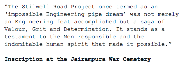
In Jairampura Cemetery, the largest cemetery dating back to the Second World War, lies the remains of hundreds of Men who gave up their lives during the building of this Road. Amongst the dead were Indians including many local Tribals, Chinese, Americans and Burmese.
17/17
17/17

• • •
Missing some Tweet in this thread? You can try to
force a refresh


