Horrific situation in Northern California... The #DixieFire has ballooned into California's 6th largest fire on record. 6 of the state's 7 biggest fires on record have occurred since last August! wapo.st/3lxXEtw by @HazardWriter (1/x)
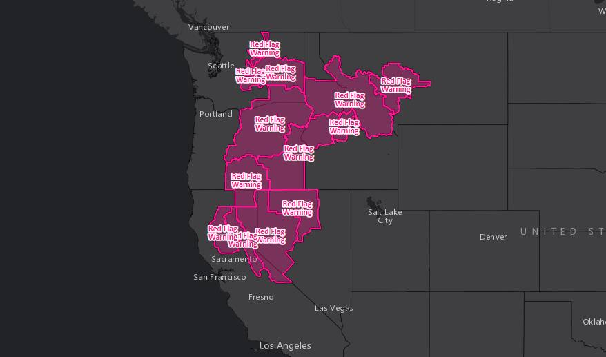
Fire conditions remain elevated to critical today in northern California and the interior Pacific Northwest. Red flag warnings up all over due to dry, windy weather and possible dry lightning. (2/x)
Drought and heat, intensified by climate change, are making these fires worse. In addition to the widespread extreme to exceptional drought, look how hot it was in June-July across the West. (3/x)
Here's the post sunrise view of some of the smoke plumes in northern California. Just devastating. (4/x)
In addition to worsening fires, the drought has depleted water levels on California's Lake Oroville - the state's 2nd largest reservoir - to its lowest level on record. Watch this animation.
Some good news in West... the critical fire danger will ease Friday and Seattle and Portland might end 50-day rainless streaks. Also, recent abundant monsoon rains have improved drought conditions in intermountain West. Shown here percent of normal rain last 30 days. (6/x)
Rains in interior West not all good...have produced flash floods and, recently, mudslides in Colorado between Grand Junction and Denver, closing a section of Interstate 70. We'll give Colo. Senator Hickenlooper last word in this thread:
One of the worst June heat waves in the West ever observed is peaking. “I’d be comfortable calling it a mega-heatwave because it is breaking 100-plus-year records, and it is affecting a wide region," said climate extremes expert Mojtaba Sadegh. wapo.st/3cOY7T4 (1/x)
On Wednesday:
* Las Vegas hit 116, just 1 degree from its highest temp ever observed
* Tucson hit at least 110 for 5th straight day
* Death Valley hit 125, highest U.S. temperature this year (2/x)
Thru Saturday:
* Tucson to extend streak of 110+ highs to 8 days, longest ever recorded
* Sacramento, Fresno, Bakersfield to see highs from 107 to 110 in Calif, near records
* Death Valley to see highs 125-126
* Phoenix to see highs 116-117
* Las Vegas highs around 114 (3/x)
THREAD - on winter storm headed to DC area. Snow moves in predawn and may become HEAVY at times sunrise into the morning. But, the question is WHEN sleet mixes and takes over. Mid-morning currently best estimate. (1/x)
Whether it's mostly snow or sleet in the morning, it will STICK w/ temps below 32. Sleet cuts down on snow totals but doesn't change the IMPACT of the storm. Because of mixing w/ sleet, we DECREASED snow/sleet forecast from 2-4 to 1-3" in DC and southern suburbs. (2/x)
Areas that get less snow from this storm will get more sleet and, unfortunately, more freezing rain. SE of DC into Southern Maryland, ice could build-up to 0.25" or more causing areas of tree damage and even power outages. (3/x)
An absolutely serious and incredible situation in Texas--2.7 million customers without power due to excessive cold and surging energy demand. While snow and ice have shut down airports in Austin and Houston. wapo.st/3s8VTDt (1/x)
This cold snap is exceptional and historic. Look at all of the records from the Gulf Coast to the Canadian border: (2/x)
Texas is almost entirely snow-covered (though some of what is shown in this image is clouds)... Never seen this before.... (3/x)
JUST IN: Our detailed look at the winter storm expected to bring two bouts of snow to the DC area between Wednesday afternoon and Friday morning. Complicated forecast, lots of variables. Read the briefing to understand the maps: wapo.st/3a1Qk3l
Important to understand the event will come in two waves. Here's our snow forecast for the first wave, Wednesday afternoon into Thursday morning: (1/2)
Here's our snow forecast for the second wave, Thursday afternoon to Friday morning: (2/2)
Forecast update! Our call for 1-4" of wet, slushy snow is on track for Sunday morning. Rain to develop between 1-4a and should switch to snow by sunrise and then taper off by early afternoon. Detailed update-write-up here: wapo.st/3aAg6L6 (1/x)
We'd lean more toward 1-2" than 2-4" near downtown DC due to mild temps and better chances for 2"+ in hilly areas with more elevation, but so much is dependent on where any heavy precip sets up. (2/x)
Most snow accumulation on grassy area but some on paved surfaces not impossible during heavy bursts. Snow can stick at 33-34 degrees if it's heavy enough. Temps - frankly - are pretty marginal for a meaningful snow event here but sometimes weird stuff happens. (3/x)
Sound the sad trombone snow lovers, we've lowered predicted totals slightly one more time. Wednesday's storm will be a mess. Detailed briefing: wapo.st/3akwBfX (1/x)
Huge range in conditions from east to west in DC region Wednesday. Flood watch east of I95 for 1-2" of rain. Winter storm warning for I81 for 6-12"+ snow. (2/x)
Between the heavy rain (east of I95) and heavy snow (near I81), a swath of freezing rain is possible, with some icing possible west of I95, esp west and north of the Beltway. Here's a model forecast of freezing rain. (3/x)