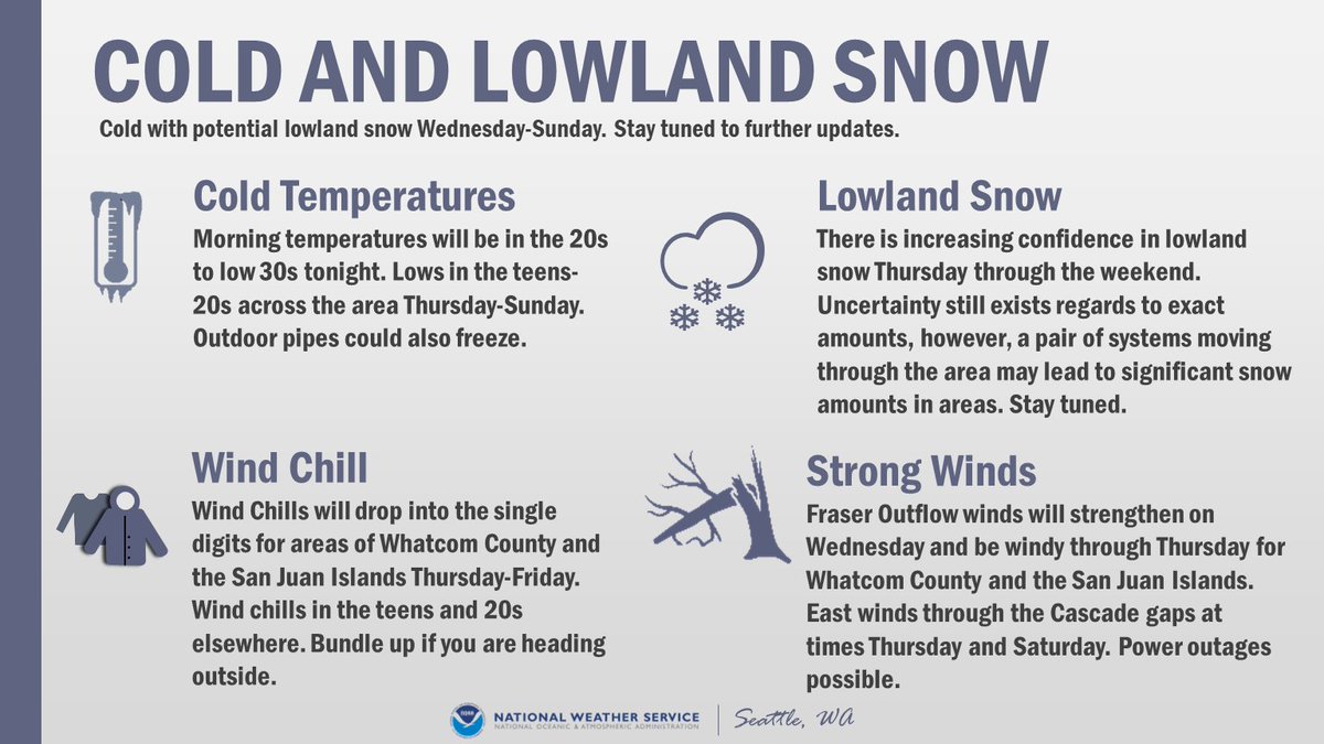
As you can see on the map at weather.gov excessive heat watches are now up for later this week. Here in Western WA it will be hot Thursday through Saturday (but not as hot as it was at the end of June). Here in Seattle we should see three days in the lower to mid 90s.
Here are some specifics on the temperature ranges for the bulk of the heat wave. The main caveat of course, would be the impact of upper level smoke and haze. In the next tweet, you'll see the chances of records being tied or exceeded. #wawx
Here are the chances of records being tied or broken on Friday and Saturday at a few locations. The daily record at SeaTac on the 13th is 92 (2002) and 95 on the 14th (2010). #wawx
Also, Fuji here would like to remind everyone to never leave their pets (or children) in hot vehicles, as temperatures inside become deadly in a short amount of time! Try not to walk during the heat of the day if it can be avoided! #wawx

• • •

Missing some Tweet in this thread? You can try to force a refresh
 

Keep Current with NWS Seattle

NWS Seattle Profile picture

Stay in touch and get notified when new unrolls are available from this author!

Read all threads

This Thread may be Removed Anytime!

PDF

Twitter may remove this content at anytime! Save it as PDF for later use!

Try unrolling a thread yourself!

how to unroll video
  1. Follow @ThreadReaderApp to mention us!

  2. From a Twitter thread mention us with a keyword "unroll"
@threadreaderapp unroll

Practice here first or read more on our help page!

More from @NWSSeattle

29 Jun
STATE RECORD?! (1 of 3)
Multiple stations in Washington state yesterday recorded high temperatures that potentially tied or exceeded the all-time record high for the state of 118°F. #wawx
STATE RECORD?! (2 of 3)
In Western Washington this includes three stations: 118 at Sol Duc River near Forks, 118 at Mayfield Power Plant in Lewis County, and 120 near Renton. #wawx
STATE RECORD?! (3 of 3)
We will be participating in the State Climate Extremes Committee & conducting initial investigations of the sites & equipment locations. Representatives from @NWSPortland @NWSPendleton & @NWSSpokane will be doing similar investigations in their areas #wawx
Read 4 tweets
10 Feb
Another round of morning thoughts from the forecast desk:

- A modified arctic front will lead to a few snow showers mainly north of Seattle today.
- The front will bring cold, but increasingly drier air to much of the region on Thursday.
- The weather system on Thursday will be battling this very dry air.
- Because of this dry air in place, we expect the best snowfall accumulation potential Thursday afternoon and night will be south of Tacoma.
- This won't be a "one and done" situation.
- Another weather system arrives Fri night & Saturday A.M. This one has greater snowfall potential across a larger portion of Western WA.
- There is still some considerable uncertainty on amounts.
- Saturday's system is less a question of "Will it snow?", but rather "How much?"
Read 4 tweets
10 Feb
Alright everyone, let's discuss the active weather pattern for this week. Here are the main areas of focus:

🌨️Lowland Snow
🥶Cold Temperatures & Wind Chill
🌬️Locally Strong Winds Morning temperatures will be in the 20s to low 30s tonight.
The active weather pattern is expected from Wednesday through the weekend. Spotty snow showers Wednesday, with increasing snow Thursday morning. The potential exists for another round of snow Friday night into the weekend. However, there is uncertainty in the forecast. #WAwx
First call snow map for Thursday-Friday Morning:

Confidence is increasing in lowland snow for Thursday-Friday morning. Expect some adjustment to these snow amounts as we approach the event. Another round of snow potentially Friday night into the weekend. #WAwx
Read 7 tweets
10 Feb
Sure, it's chilly out there, but it'll get colder. Here's a hand drawn map over a satellite image taken from the NOAA 20 polar orbiting satellite today. A weak system moving south through B.C. with a give a modified arctic front a shove southward tomorrow.
That's the precursor to more interesting weather later Thursday into Saturday. Outflow finds through the Fraser River Valley will increase substantially by Thursday - which provides Western WA with additional (and colder) air.
Moisture arriving from our southwest on Thursday will "overrun" the cold air in place - and that's the final ingredient for snow. On a side note, the yellow arrows point to "cloud streets" formed by the chilly air escaping B.C.'s interior.
Read 4 tweets
7 Feb
[🥶THREAD] We hit on snow in a thread earlier so now let's talk COLD! Much colder air is on the way for the rest of the weekend with the coldest temperatures mid to late week. Overnight lows will likely drop below freezing, into the teens and 20s for many locations. #wawx
While we're confident it'll be some of the coldest air we've seen this winter, this is still uncertainty in just how low temperatures may drop! Here's a look at the ranges we might see by Friday morning! #wawx Image
In addition to the cold - gusty northeast winds from the Fraser River Valley near the Canadian border are expected to flow into western Whatcom, Skagit, and the San Juans. Need a refresher on Fraser Outflow? Check out this video: #wawx
Read 6 tweets
7 Feb
[THREAD] First up for our afternoon forecast updates is the lowland snow potential! We'll post another thread with info on the cold later so it's easier to keep it all straight! 🥶 #wawx
A convergence zone will develop this evening - tonight that has the potential to drop snow levels to 500-1000 feet (potentially slightly lower) with thin bands of heavy showers. This may bring light snow accumulations across portions of the lowlands - see graphic. #wawx Image
So what's still uncertain?
❄️Exactly where these thin bands of heavy showers will develop
AND
❄️How much snow may accumulate on roadways given above freezing temperatures
We'll certainly have frequent updates here as things develop so stay tuned! #wawx
Read 5 tweets

Did Thread Reader help you today?

Support us! We are indie developers!


This site is made by just two indie developers on a laptop doing marketing, support and development! Read more about the story.

Become a Premium Member ($3/month or $30/year) and get exclusive features!

Become Premium

Too expensive? Make a small donation by buying us coffee ($5) or help with server cost ($10)

Donate via Paypal Become our Patreon

Thank you for your support!

Follow Us on Twitter!

:(