BGWX Profile picture
Sep 1, 2021 7 tweets 4 min read Read on X
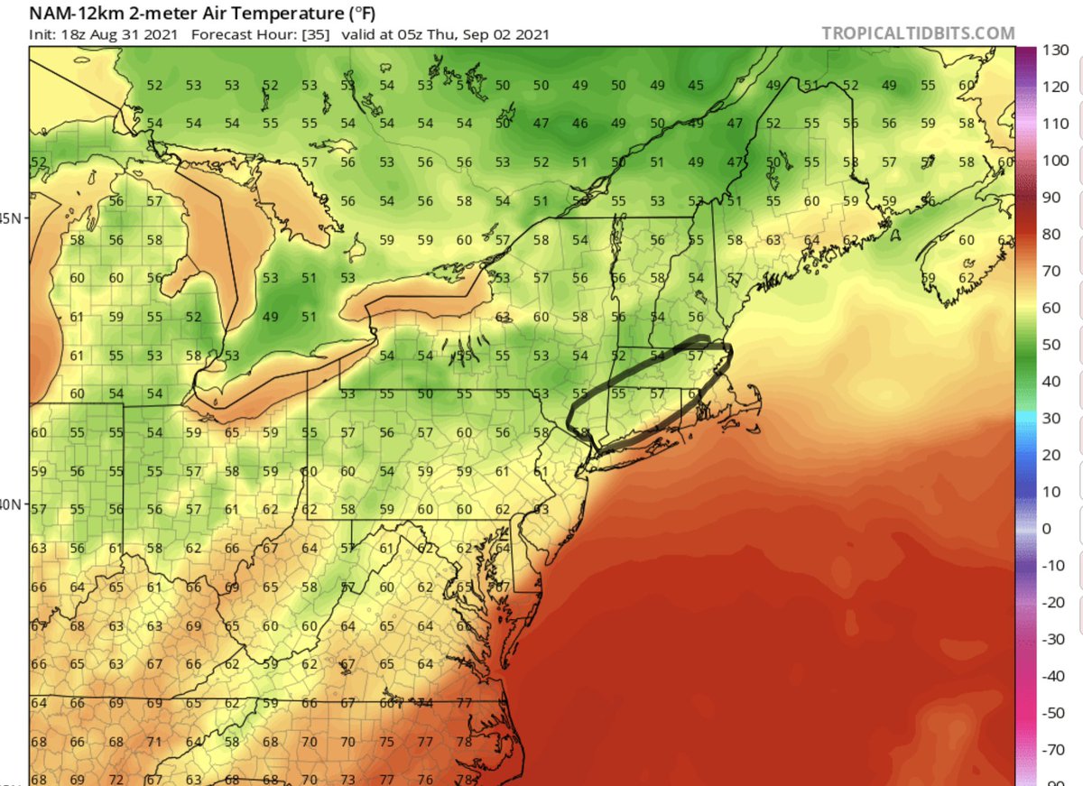
My next thread focuses more on New England and Hudson Valley where you can see what I have. To be clear areas outside can see 3-6” even 4-8” too but this is area I’m highlighting most for concern of seeing isolated double digit rainfall totals. Go in depth 👇 #mawx #ctwx #nywx
As I mentioned before FGEN banding setup will create forcing and lift in the atmosphere and along that front we’ll have to look for prolific rainfall rates being setup. Imagine in a winter storm where areas that get the most banding we’ll see the most snow but surrounding…
Areas still get a lot of snow just not 18-24 but instead the 8-14” totals. In this case it’s rainfall though so areas outside of that banding we’ll still see 2-4/3-6” of rain which is a lot but areas just north of the front will have a chance to see over a half foot and maybe…
Double Digit rainfall totals in really isolated areas. Flash flooding is an extreme concern as the heaviest bulk of rainfall will fall in a 4-6 hour timeframe with a 12 hour window of possible precipitation. Finally the thread for strong winds should be noted too👇…
Here’s the low level jet depiction of Euro for next couple days. Shows more amplified low level jet then most models especially compared to GFS. But the idea is the heavy rainfall will mix some of these stronger winds down to the surface…
So the idea is 25-40mph wind gusts inland with 35-50mph gusts closer to the coast. This might change some but here’s a rough idea what might play out. Possibly a little bullish but Euro does ok with baroclinic processes, better than GFS so I’ll do a combo of both…
Given there has and will be a lot of rainfall roots and trees will be very susceptible so power outages are definitely possible for some areas but for now I don’t think they will be widespread and will be contained closer to the coast if they do happen. Hopefully ya’ll stay safe

• • •

Missing some Tweet in this thread? You can try to force a refresh
 

Keep Current with BGWX

BGWX Profile picture

Stay in touch and get notified when new unrolls are available from this author!

Read all threads

This Thread may be Removed Anytime!

PDF

Twitter may remove this content at anytime! Save it as PDF for later use!

Try unrolling a thread yourself!

how to unroll video
  1. Follow @ThreadReaderApp to mention us!

  2. From a Twitter thread mention us with a keyword "unroll"
@threadreaderapp unroll

Practice here first or read more on our help page!

More from @BradyBGWX

Sep 1, 2021
Massachusetts has the potential to see a very high end flood event by the way too I keep hearing PA to CT. Just cause that’s where the high risk doesn’t mean MA isn’t as risk to see some dangerous even borderline life threatening rainfall too. MA is less than 15 miles away from..
Edge of the high risk btw too and the risk for 3-6 and 4-8” of rainfall definitely exists for MA particular around and S of 495. So if you hear PA-CT that doesn’t mean MA is not as risk to see life threatening flash flooding because we most certainly are even if there is a...
Slightly higher chance for deadly flooding to the S and W MA is by no means in the clear of flash flooding with life threatening potential.
Read 4 tweets
Sep 1, 2021
The NHC explicitly states in their forecast cone it can multiple categories off days out in advance. That’s why the NHC makes the cone for 1-3 days and why it’s called the extended cone days 4 and 5. The 1st forecast explicitly called for a rapidly intensifying hurricane...
The forecast was very clear even 5 days out the potential for a major hurricane was very much increasing in likelihood. The messaging was clear as well along with models indicating a Cat 4 storm was possible. If u can’t understand how the NHC cone works I dont think you should...
be relaying the forecast. If u understood the frequency the NHC forecasts a near Major Hurricane 5 days in advance then it would have been clear a Category 4 was certainly possible. Or if u understood what kind of environment from a meteorological perspective Ida was moving into.
Read 8 tweets
Sep 1, 2021
I’m going go out on a limb here and say someone in this highlighted area is probably going to get a foot plus of rain tomorrow. Not widespread to be clear but isolated totals 12”+ are definitely reasonable. I’ll explain below👇 #pawx #njwx #ida #rain #flooding
As Ida will be undergoing baroclinic process and transitioning from a tropical depression into a extratropical storm we’ll actually see some similarities to a winter storm. Warm air advection will be playing a part in aiding Frontogenesis tomorrow across the Northeast as…
The contrast in temperature as noted in the pictures will create an enhanced area of lift. Along the edge of those juiciest dewpoints and under the FGEN setup that is where a combination of the best forcing along with moisture content will be aiding in producing anomalous…
Read 6 tweets

Did Thread Reader help you today?

Support us! We are indie developers!


This site is made by just two indie developers on a laptop doing marketing, support and development! Read more about the story.

Become a Premium Member ($3/month or $30/year) and get exclusive features!

Become Premium

Don't want to be a Premium member but still want to support us?

Make a small donation by buying us coffee ($5) or help with server cost ($10)

Donate via Paypal

Or Donate anonymously using crypto!

Ethereum

0xfe58350B80634f60Fa6Dc149a72b4DFbc17D341E copy

Bitcoin

3ATGMxNzCUFzxpMCHL5sWSt4DVtS8UqXpi copy

Thank you for your support!

Follow Us!

:(