1/9 To shed some light on the science, here's a schematic look at the structure of a downslope wind event along the Wasatch Front. For more detail on this graphic and the setup for this impactful event, keep reading... #utwx
2/9 The September 2020 wind storm was a complex meteorological event combining elements of strong synoptic winds associated with deep low pressure system with components of a classic downslope wind event. It was this combination that led to a widespread, long-duration event #utwx
3/9 A pool of cold continental air moved southward from Canada through the Intermountain West with the progression of an upper-level trough. As the system deepened, upper level winds (our 'background' flow) increased, and significant transport of this dense cold air occurred.
4/9 The background flow set the stage for a strong wind event, the downslope component enhanced them to the highly impactful level we experienced. The cold air transported into the region is channeled and trapped by the Wasatch and Uinta Mountains, creating a deepening cold pool.
5/9 Eventually, the depth of the cold pool becomes sufficient so that easterly winds allow the cold air to overtop the Wasatch Front, spilling onto the west side. The dense cold air accelerates as it descends under a stable layer, producing enhanced winds along the Wasatch Front.
6/9 This process can also 'mix' the upper-level flow down to the surface, with the two processes working together to produce winds well in excess of 60 mph up and down the Wasatch Front.
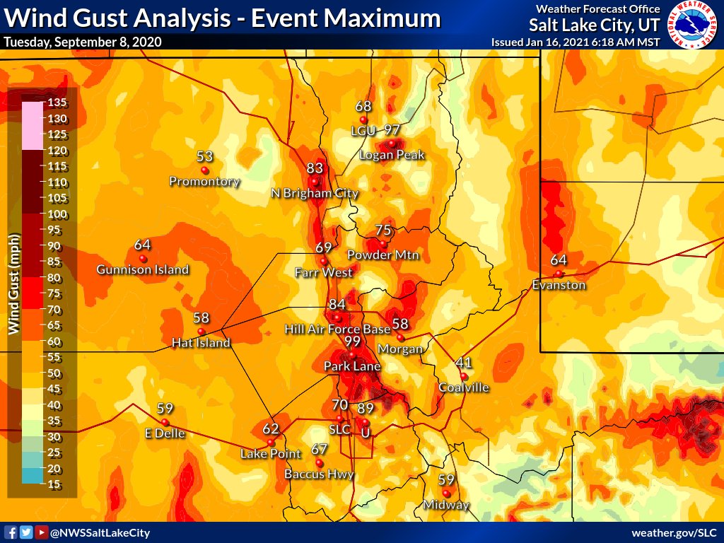
7/9 To get some of the highest wind gusts (US-89 at Park Lane reaching 99 mph), canyons along the Wasatch Front provided the final component, further channeling the dense cold air, and with the stable layer as a 'lid,' forces the flow to accelerate as it reaches the valley floor.
8/9 One of the unique characteristics of a downslope wind storm that was evident during this event is the 'hydraulic jump' and rotor. This was responsible for the light easterly winds on the northwest end of the Salt Lake Valley and chaotic wind directions near the SLC airport.
9/9 There are many more pieces to the puzzle as downslope events are incredibly complex. Many subtle ingredients must come together with the terrain and the 3-D structure of the atmosphere to produce an event like this. We hope you enjoyed some basics! #utwx

• • •

Missing some Tweet in this thread? You can try to force a refresh
 

Keep Current with NWS Salt Lake City

NWS Salt Lake City Profile picture

Stay in touch and get notified when new unrolls are available from this author!

Read all threads

This Thread may be Removed Anytime!

PDF

Twitter may remove this content at anytime! Save it as PDF for later use!

Try unrolling a thread yourself!

how to unroll video
  1. Follow @ThreadReaderApp to mention us!

  2. From a Twitter thread mention us with a keyword "unroll"
@threadreaderapp unroll

Practice here first or read more on our help page!

More from @NWSSaltLakeCity

8 Sep
1/7 It is the first anniversary of the 2020 Downslope Wind Storm that impacted much of northern Utah. This event goes down as one of the most widespread, impactful weather events the state has experienced in many years. This thread details some of the impacts. #utwx
2/7 Here are the peak wind gusts for the event across northern Utah. Wind gusts as high as 99 mph were reported (with unofficial reports near the U over 100 mph).
3/7 Initial reports estimated more than 4500 trees were damaged or downed during the event across mainly Salt Lake, Davis and Weber Counties. Liberty Park lost near 70 trees. Some of these tress were up to 100 years old. Tree damage was especially severe due full leaf canopies.
Read 7 tweets
20 Aug
1/8 For those wondering why the mountains are no escape from the smoke these days... One key difference between our wintertime valley pollution and summertime smoke is the presence or lack of a stable layer in the form of a temperature inversion. #utwx
2/8 This oversimplified graphic shows how the stable layer/temperature inversion creates a cap that traps a shallow layer of pollution near the surface in winter, while under warm and well mixed summer conditions, these pollutants (like smoke) are distributed throughout.
3/8 There are scenarios where the concentrations are high near the surface, and others where the surface remains relatively 'clean' while concentrations aloft are very high. But with enough smoke, over sufficient time and distance, distribution in the column becomes homogeneous.
Read 8 tweets

Did Thread Reader help you today?

Support us! We are indie developers!


This site is made by just two indie developers on a laptop doing marketing, support and development! Read more about the story.

Become a Premium Member ($3/month or $30/year) and get exclusive features!

Become Premium

Too expensive? Make a small donation by buying us coffee ($5) or help with server cost ($10)

Donate via Paypal Become our Patreon

Thank you for your support!

Follow Us on Twitter!

:(