The South Pole just had its most severe cold season on record (back to 1957). We were frankly *shocked* to learn & confirm this was true while reporting this story. But the science is fascinating & in no way refutes the reality of global warming: wapo.st/3ioZfjd 1/x
We should give credit to @pinturicchio_60 who (we believe) first posted this. We weren't sure it was legit but talked to several researchers and it checks out: (2/x)
So how cold was it at the South Pole? The average temperature over the last six months was MINUS-78 degrees!!! At times, it was around MINUS-100. (3/x)
But here's the obligatory visual to show how what's happening in Antarctica IN NO WAY invalidates the unmistakable, unambiguous, unequivocal global warming signal, courtesy @ZLabe: (4/4)

• • •

Missing some Tweet in this thread? You can try to force a refresh
 

Keep Current with Capital Weather Gang

Capital Weather Gang Profile picture

Stay in touch and get notified when new unrolls are available from this author!

Read all threads

This Thread may be Removed Anytime!

PDF

Twitter may remove this content at anytime! Save it as PDF for later use!

Try unrolling a thread yourself!

how to unroll video
  1. Follow @ThreadReaderApp to mention us!

  2. From a Twitter thread mention us with a keyword "unroll"
@threadreaderapp unroll

Practice here first or read more on our help page!

More from @capitalweather

14 Sep
#Nicholas made landfall along the middle Texas coast overnight as hurricane, unleashing wind gusts up to 95 mph, a surge over 4 ft, and 14" of rain in Galveston. 500K lost power. Now a tropical storm, it's a serious rain threat for Louisiana. wapo.st/3zb20dx (1/x)
The problem? The storm is forecast to slow to crawl, unloading widespread 5-10" of rain in waterlogged southern Louisiana, just ravaged by #Ida. Rain could linger for 36 hours and isolated totals to 20" poss. (2/x)
A rare "high risk" of flooding/excessive rain in Beamont-Port Arthur to Lake Charles area, which was socked by two hurricanes last year while a moderate risk extends into New Orleans. (3/x)
Read 4 tweets
14 Sep
JUST IN: #Nicholas strengthens to hurricane. Winds gusts have reached 80 mph along middle Texas coast, with over 25K w/o power. Biggest hazard still expected to be rain/flooding.
Updated storm briefing: wapo.st/3hs6J4p
Some good news for Houston is that over the course of today projections have shifted to more of a coastal rather than inland track and heaviest rainfall may focus to its south, closer to Galveston area. Even so, heavy rain, flooding still poss there into Tuesday.
Per @NHC_Atlantic -- #Nicholas produced sustained wind of 76 mph and gust to 95 mph at Matagorda Bay last hour. Over 30K without power along central Texas coast according to poweroutage.us
Read 4 tweets
13 Sep
Very heavy rain about to move onshore along middle and upper Texas coasts, including Houston. @NWSWPC predicting up to 4-6" of rain thru 10p local time, along with flash flooding.
Update: wapo.st/3hs6J4p
Radar shows massive area of rain starting to move onshore Middle Texas coast at 535p eastern:
Sprawling area of coastal Texas and Louisiana under flash flood watches, which extends well inland, due to #Nicholas.
Read 4 tweets
13 Sep
Serious rainfall situation for Texas + Louisiana Gulf Coast due to Tropical Storm #Nicholas. Forecast for Houston? 8-16 inches - heaviest tonight into Tuesday AM. Rare "high risk" of flooding middle-upper Texas coast. wapo.st/3hs6J4p
Here's a model simulation of #Nicholas making landfall tonight and its rainfall...extremely heavy rain esp east of where it comes ashore. @NWSHouston has said rates of up to 3-4" per hour.
As always, our friends @SpaceCityWX and @MattLanza providing excellent in-depth local perspective. They rate the flood threat at level 3 of 5 for Houston, with potential 100s of homes flooded.
Read 5 tweets
8 Sep
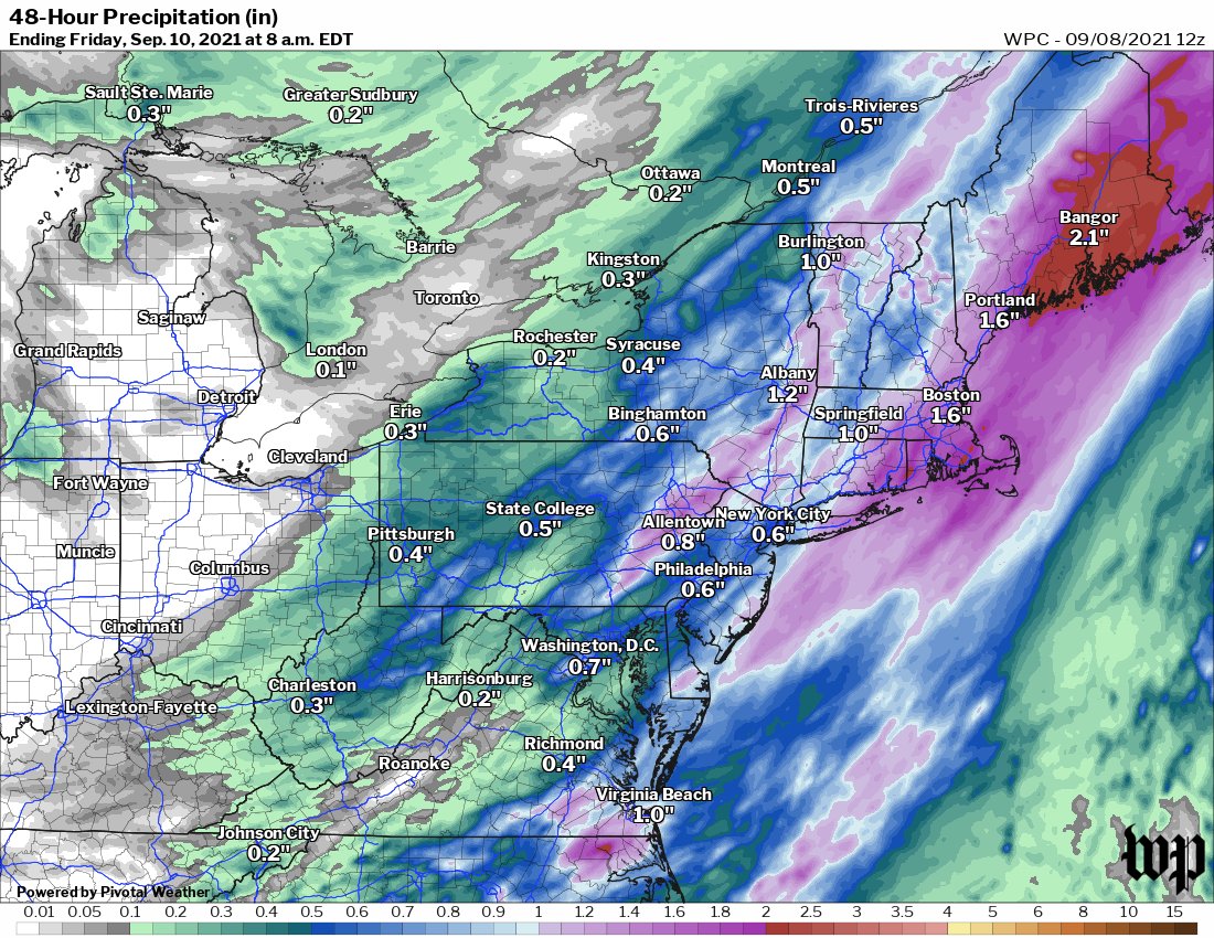
Storms coming tonight in the Mid-Atlantic and Northeast due to cold front. Yes, they will come one week after #Ida but they will *not* be as widespread or severe in most cases. wapo.st/3zX5i55 (1/x)
First around DC, most likely timing of showers and storms 5 to 10p although newer data leans toward 8-10p or even a bit later for a more widespread line of storms. Isolated severe possible...but heavier action probably to our north. (2/x)
Rain potential in Mid-Atlantic and Northeast generally 0.5-1", but pockets of 1-2" possible. In E Pa and parts of NJ/NY, they've had up to 600% of normal rain in recent weeks, so won't take much for flash flooding. (3/x)
Read 4 tweets
31 Aug
Potentially serious weather day in DC area Wednesday-Wednesday night as Ida moves through.
1) Flooding risk, especially in our northwest areas
2) Severe storm/tornado risk in the immediate area
Detailed briefing: wapo.st/3mPNbuo (1/x)
We expect 1-3" of rain in the immediate DC area thru Wednesday night; with some localized flooding issues. But more significant flooding issues possible west and northwest toward I-81 where 3-6"+ possible. (2/x)
River flooding will become a concern by Thursday due to all of the rain not only falling from this event but we've had more than twice the normal rainfall this month. Major flooding forecast for Monocacy River in Frederick. (3/x) Graphic via @NWSMARFC
Read 5 tweets

Did Thread Reader help you today?

Support us! We are indie developers!


This site is made by just two indie developers on a laptop doing marketing, support and development! Read more about the story.

Become a Premium Member ($3/month or $30/year) and get exclusive features!

Become Premium

Too expensive? Make a small donation by buying us coffee ($5) or help with server cost ($10)

Donate via Paypal Become our Patreon

Thank you for your support!

Follow Us on Twitter!

:(