Countdown #FairMaps for Arizona: 60 Days! 60 DAYS.
I've summarized the @ArizonaIRC 6.0 Congressional plan below. Worry not. Marana and Oro Valley are united. Other key stats and pictures follow.
I flag 1) the over performance (?) of CD3 as a VRA district and 2) the loss of
I've summarized the @ArizonaIRC 6.0 Congressional plan below. Worry not. Marana and Oro Valley are united. Other key stats and pictures follow.
I flag 1) the over performance (?) of CD3 as a VRA district and 2) the loss of

an opportunity district for Am. Indians as testament that changes are still to come.
NOW would be a really good time for the Navajo Nation and other IC to come forward with a unity map. These changes will push lines around all over the place -
NOW would be a really good time for the Navajo Nation and other IC to come forward with a unity map. These changes will push lines around all over the place -
but if you squint you can see the outlines of new congressional districts --
Top lines of the @ArizonaIRC V6.0 Congressional Plan
* 4 safe R seats (Districts 2, 5, 8, and 9);
* 2 safe D seats (Districts 3 and 7);
* 3 lean D seats (Districts 1, 4, and 6).
Top lines of the @ArizonaIRC V6.0 Congressional Plan
* 4 safe R seats (Districts 2, 5, 8, and 9);
* 2 safe D seats (Districts 3 and 7);
* 3 lean D seats (Districts 1, 4, and 6).
This plan has two Latino VRA districts (Districts 3 and 7); and no opportunity district for the Am. Indian communities in northern AZ.
CD 2 while having a 7.4% spread just outside 7-points for competitiveness, it performs as a safe Republican district. District specifics:
CD 2 while having a 7.4% spread just outside 7-points for competitiveness, it performs as a safe Republican district. District specifics:
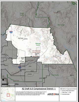
CD 1 - All in Maricopa County - Cave Creek. Paradise Valley, Fountain Hills, and Scottsdale; Fort McDowell Yavapai Nation. Stops at northern MarCo border and goes to east but stops east at Gila County border and south at Pinal County border. 

This district has a 1.6% vote spread; Dems win 5; Republicans win 4 of the 9 measured elections. Would be deemed "very competitive." Swing; slight lean Democrat.
CD 2 - All of Apache, Coconino, Gila, Navajo and Yavapai Counties AND Graham, Mohave, and Pinal counties are split to add population. This district includes the Navajo Nation, Hopi, Fort Apache, and San
Carlos and Gila River American Indian communities. Mohave County is split to include Havasupai, Kaibab, and Hualapai Am. Indian communities. Native Indian CVAP is 20%, the highest of any congressional district. But this is no longer an Am. Indian opportunity district. 

Don't know how this is not retrogression. Count them: 8/15 counties in Arizona are all or a part of this monster district. This district has a 7.4% spread - but votes consistently Republican in 9 of 9 measured elections. Safe Republican.
CD 3 - All in Maricopa County - runs N/S from Glendale to Gila River Indian Reservation but does not include the reservation. E/W it goes from Guadalupe/ I-60 past Avondale to the west. Includes part of Glendale, Tolleson, Avondale, Guadalupe, and downtown Phoenix. 

This district has 54% Hispanic Citizen Voting Age Population (H-CVAP) and a 48.4% vote spread making it reliably democratic in 9 of 9 measured elections. VRA vote for 2018 Gov. and AG race are 68.0% and 73.2% respectively.
NOW, you all KNOW I did NOT go to law school. And still I ask, does this look like "packing?" It is almost certainly over-performing. VRA; safe Democrat.
CD 4 - All in Maricopa County - This east valley district includes Tempe, Mesa, & Gilbert. It also includes the Salt River IC as was their request to connect w/Tempe. This district has a 5.6% spread; Democrats win 8 of 9 measured elections. Competitive; but swings Democrat. 

CD 5 - This east valley district combines the communities of Chandler and Queen Creek in Maricopa County and Apache Junction in Pinal County. This district has a 14.8% vote spread and is reliably Republican in all nine of the measured elections. Safe Republican. 

CD 6 - The "teapot" district is anchored in the SE corner of the state with Cochise County, adds all of Greenlee County, southern Graham County, the northeast corner of Pima county and picking up the important community of interest of Marana and Oro Valley, and the teapot spout 

up through Pinal County to add the community of Coolidge and the Ak Chin American IC. This district has a 1.8% vote spread making it "very competitive"; Democrats and Republicans split wins 6/3 respectively in the nine measured elections. Swing; leans Democratic.
CD 7 - This is the southern border district starting at Santa Cruz County and going west to the Calif. border in Yuma County taking in the Hispanic communities south of the I-10; including the southwest corner of western Maricopa County and parts of Pinal county 

including Eloy and keeps the Tohono O'odham Nation united. This district has 47% Hispanic CVAP and a 19.9% vote spread. Democrats win 9 of the 9 measured elections and both the 2018 Dem and AG races 53.2%-60.3% respectively. VRA and Safe Democrat.
CD 8 - This is an all Maricopa County district including the retirement communities of El Mirage and Youngtown; but not the Sun Cities or Surprise. This district is roughly north of Northern up to the 303 loop; and goes E/W from El Mirage to SR - 51 to the east. 

This district has a 6.3% spread which puts it in the "competitive category, but it is reliably Republican with Republicans winning 9 of the 9 measured election. Safe Republican.
CD 9 - This district includes all of Mohave and LaPaz counties, the northern half of Yuma County north of the I-10. However, the majority of the district's population comes from Maricopa County by 

including Wickenburg, the Sun Cities, Surprise, Litchfield Park, Goodyear and Buckeye. This district has a 27.2% vote spread. Safe Republican.
Tomorrow - God willing - the same for LD version 8.0.
Tomorrow - God willing - the same for LD version 8.0.
• • •
Missing some Tweet in this thread? You can try to
force a refresh


