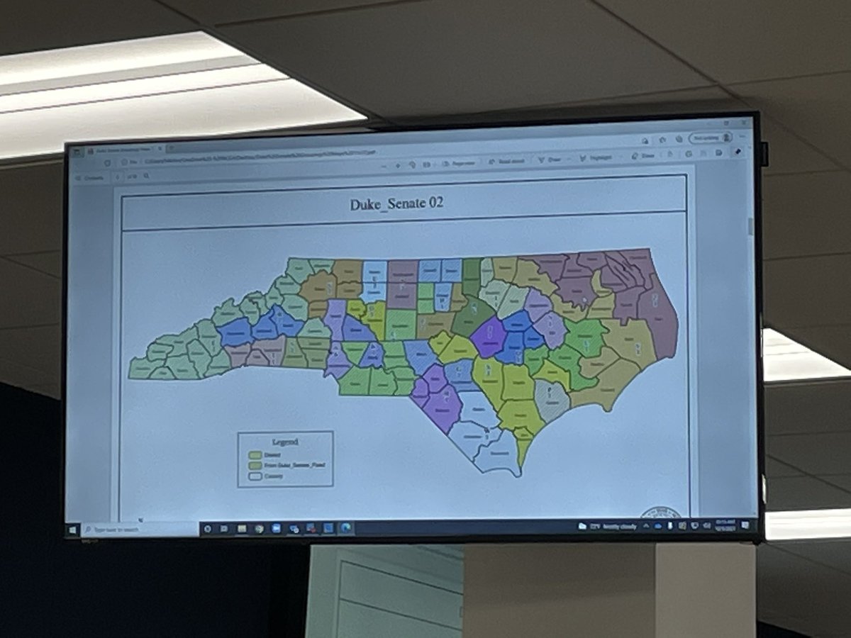
Here in the #NCGA Senate Redistricting Committee meeting - senators are debating the proposed Republican Congressional map - Sen. Willey Nickel is showing something on a posterboard but I can't see it from here. #ncpol 

Nickel says that we're a 50/50 state but the map gives 10-11 safe Republican seats out of 14.
Nickel cites the infamous 10-3 statement by Lewis. Says that the chairs don't need to say anything like that because the map speaks for itself.
Nickel asks how greedy Republicans are going to be with these maps - you're guaranteeing action by the State Sup. Ct.
Nickel says this map is "cheating, plain and simple" - Nickel asks Sen. Daniel how you can get a map like this that is an extreme partisan gerrymander without using partisan data.
Daniel says that it's totally the result of political geography - (which is ridiculous because this map splits up a number of those communities they say are so concentrated)
Sen. Marcus says that it's the three largest counties are split three ways - which is unnecessary - so why was it done. Asks how this complied with criteria?
Hise says criteria were not ranked, and only 11 counties are split. Marcus says that splitting these three largest counties three time gives Republicans an advantage.
Marcus says she reviewed comments and says that none asked for southeastern Mecklenburg to be connected to the Sandhills, she asked if Hise knows of any such comments.
Hise says he doesn't have any specific comment in mind. Marcus says that the comment Hise used to justify the north Meck split was represented.
Sen. Blue asks whether Daniel said that Raleigh and other Wake municipalities share a common interest. Daniel says he did.
Blue asks why don't the remaining municipalities in Wake share an interest with each other? Daniel says it's a population issue (FYI Wake only needs to be split once for population, not twice as in this map)
Daniel says again that the justification is just population.
Daniel is revealing he doesn't actually know the municipalities in question.
Blue asks the same question about Guilford county. Daniel says he doesn't know what the people of municipalities in Guilford would say.
Blue asks Daniel which counties are the Sandhills counties and what is the anchor of the Sandhills. Daniel says he can't answer that question.
Blue asks if Union County is a Sandhills county based on the geologic factors. Daniel says he doesn't know - but thinks Blue is splitting hairs and we're all Americans and people are making too much of the differences between counties (lol)
Blue says that High Point is in four counties - was High Point kept whole - Hise says that when a city is split between counties it doesn't count as a municipal split in the system.
Blue says that the kind of illustration that Sen. Nickel just showed us is what any mathematician in the state would say. Says he hasn't seen any proof that that evaluation is wrong.
Blue says he's concerned because we went through this in 2019 and got a map that was 8-5 - this is spitting in the face of the court with an 11-3 map.
Blue asks what the common sense basis is for taking chunks of Guilford and Wake out, splitting them up in a way you're not splitting up any other counties.
Common sense would tell me, if I were a judge, that there is something else at work here than what you're saying (referring to the splitting of these urban areas)
Blue says that neutral parties should be doing this - but radical, extreme maps like this are an argument for legislators to be take outside of the process.
Sen. Perry says too many lawyers are involved in the process. Says they're behind all the conversations in the committee. Brings up that Nickel is running for Congress and so is self interested.
Perry says that counties with over 700,000 have to be split (again, they do not have to be split more than once as they are in this map)
Sen. Lowe says Winston, Greensboro, and High Point have more in common than most cities on this map - to split them into three districts, he says he can't make sense of it.
Forsyth county is connected to Lincoln "What in the hell do we have to do with Lincoln" - says he wants to understand why.
Says the community that he lives in (the Triad) - this is a blatant legislative move to pull this community apart. Says people in his community are not asking for this.
Guilford and Forsyth should naturally be together - what is the rationale for "discombobulating" this area.
Daniel says they followed the criteria the best they could and are only splitting 11 counties. (Not answering the question all together)
Lowe asks for a real answer, and that answer is not it.
Sen. Don Davis says that it's important to him that the people's voices in this process, in all processes - taking the time to listen to the people of this state.
Davis says his question is what was the total number of individuals that made comments - Hise says that no one has that information currently.
Davis asks whether there is a record of the comments that were used to inform this map
Hise says that total online comments are 4,037
Davis asked how this map aligns with the comments given. Daniel says they have no number - Hise says they're not all strictly relevant anyway. We have no record of how or if any of them were used.
Sen. Nickel says this map is begging for court intervention. Cites the section of the NC state constitution "All elections shall be free" and the court's decision made on that basis that extreme partisan gerrymandering is unconstitutional
Asks how the chair defines extreme partisan gerrymandering - Hise says that he's not going to define a court generated term. Just says that they have not looked at partisan or racial data, the results are what they are.
Nickel asks if a map that elects 79% Republicans are fair maps. Hise says that a map that uses partisan data isn't fair.
Newton moves for a favorable report. Blue asks how the committee can do that when there are maps from other legislators that are not being addressed. Hise says that the committee can pass as many map bills as it wants and see what happens on the floor.
Marcus asks about how the VRA applies to this map - she says she asked for a racially polarized voting study. Has that been done and is it reflected in this map. Hise says no to all of this.
And the vote was held and the Republican Congressional map passed.
Sen. Clark's congressional map is raised next - this is version CCH-6 and Clark has an amendment to it ready as well.
This is the map without the amendment.

Looks like Sen. Chaudhuri's map will also be raised at some point.
Clark starts with CCH-6 - contrasts his map with the map from the chairs - his Western district doesn't go up to Watauga like the chairs' - his amendment changes that.
The amendment changes Wake county to look like it does in Sen. Chaudhuri's map. Clark also unsplit one VTD.
Hise puts the committee in recess for 20 minutes for the committee to review Clark's map. We'll be back at 10:25.
Missed a bit but Clark is explaining his map now.
Apparently chairs advocated for their map by saying it creates a Sandhills district (it doesn't) - Clark points out that the commenter they mentioned actually supported a previous version of his map (CBK-4) by name that has the Sandhills district he described.
Here's Clark's graphic showing that the Sandhills is the only region without a dedicated Congressional district

Clark shows the NC Prosperity Zones as an example of which regions naturally share interests

He also gives Area Health Education Center Regions as an example

Clark says that people at hearings asked for Congressional district 6 to remain intact (that's the current Triad district) - speakers also asked for Kernersville to be included in that district. His map reflects that feedback.
This is his map with the amendment

The white line splits the state into east and west, and Clark has given each side 7 districts
Clark is giving a very thorough explanation of his reasoning for each district he drew - the opposite of what we got for the Republican map.
He also points out that his map doesn't double bunk any incumbents
He moves on to the Sandhills - he says that 40% of people who spoke asked for a Sandhills district - they were people mostly from Moore, Cumberland, and Robeson counties
He says that Ft. Bragg is a huge influence on the state and the area. People mostly think of it being in Cumberland, but the majority of Ft. Bragg is actually in Hoke County.
I believe he said Richmond has a training area for special forces. Also lower third of Moore County is a military impact area as well. With those things in mind he drew his Sandhills district.
This map has Moore, part of Richmond, Hoke, Scotland, Robeson, Cumberland and part of Harnett.
Clark says he changed a district in response to a public comment. Says he knows that legislators know how precincts trend in a partisan sense. But his objective was a fair map, without respect to partisanship.
People in the Sandhills are tired of being split. They deserve a rep. who lives in the Sandhills, not Charlotte or Cabarrus.
He says he chose part of Harnett because many military families live there.
A previous version of his map split Onslow County, but he changed that in response to comments.
He is now going to talk about the Voting Rights Act district. Says since he couldn't use racial data in his map. Instead he used the "VRA" district map from the 2011 Senate map.
(This is the map that Hofeller produced after being asked to draw as many 50+1% BVAP districts as possible) - Clark says he knew that if he included counties from this map it would make sure Black voters there would have the opportunity to elect a candidate of their choice.
(This is actually pretty clever - and kind of hilarious)
Clark points out the word game that Republicans are playing when they say their map only splits 11 counties - this obscured the fact that those large counties are split more than once (and more than necessary)
He says that his map also only splits 14 VTDs and the Republican map splits at least 24 VTDs.
Sen. Blue asks Clarks about what other considerations he made in drawing the Sandhills district. Clark talks about regular commuting patterns among the counties.
Many of those counties are majority-minority counties - and they wonder why they are constantly getting split. Compared the way the Republican map splits the area into three different districts - says no one in that area wants that.
Even the former chair of the Republican party there spoke in favor of a Sandhills district. A retired army general also spoke in favor of a Sandhills district.
"They are tired of being sliced, diced, and split up." They deserve a congressional area like every other region.
Blue says that in Robeson, Cumberland, Hoke, and Scotland - 90% of the Lumbee who still live in NC are in that area - the biggest group of native people east of the Mississippi
Sen. Newton asks whether Clark considered partisan or racial considerations. Clark says absolutely not.
Newton said that Clark's map splits more counties than the Republican map. Clark says that he can't do that at this time without looking at the actual map in the software.
Newton lists the municipal splits that Clark's map has that the Republican map doesn't.
Clark says that all splits are no equal. For example the Dunn split splits off only one person who lives in an adjoining VTD.
Nickel says that saying that the map that they just passed is fair and not a partisan gerrymander is laughable. Asks Clark how outside groups graded these maps.
Clark says that Princeton Gerrymandering Project rated his maps as As, they said that his map is proportional even though he didn't use partisan or racial data.
He realizes that proportional representation wasn't part of the criteria or required by our constitution - he relied on what ordinary people would think was fair in drawing.
Sen. Marcus asks Clark whether he believes any part of Mecklenburg county is part of the Sandhills. Clark says that a woman giving a comment in Robeson stayed in the same district even though she moved from Mecklenburg to Robeson.
Clark says that Mecklenburg and Robeson are two completely different worlds and shouldn't be in the same district.
Marcus asks about the compactness scores of both maps.
Marcus asks about the compactness scores of both maps.
Clark says that legislators can talk about all the different compactness scores available. But his approach was focused on what ordinary people would want.
Clark says that the committee only cited two measures of compactness while 30+ exist and didn't actually set any numerical standards for compactness. Clark says that when you talk to ordinary people they don't think that way.
Hise says that compactness scores are part of the stat pack.
Daniel says that Sen. Lowe cited that the previous map put Forsyth with Lincoln, but Clark's map splits Forsyth and pairs half of it with mountain counties. Says Lowe should like the Republican map better.
Daniel says the municipal splits in Clark's map are worse than the splits in the Republican map.
Hise doesn't allow Clark to respond to this.
Sen. Edwards says a key criteria in 2019 was not splitting municipalities. This is what was actually in the court order.

The committee votes down Clark's map
Sen. Chaudhuri's congressional map is next.

Chaudhuri says the average Reock and PP compactness scores for his map were .45 and .36. It also does not double bunk any incumbents, creates a Sandhills district, and only splits Wake and Mecklenburg once each.
Newton tries to go after Chaudhuri on municipal splits - Chaudhuri says VTDs, Cities, and counties are all important - the committee did not prioritize criteria so you have to make trade offs among those.
(Municipal splits are such a red herring. I don't care if you split fewer municipalities if your map is gerrymandered to all hell)
Marcus asks Chaudhuri about the splits in Mecklenburg, Guilford and Wake - how does Chaudhuri compare.
Chaudhuri says that the Princeton Gerrymandering Project gave the Republican map an F for partisan fairness. Chaudhuri's map got a grade of A and no party gets a partisan advantage from it.
Chaudhuri says outside groups have said his map is 4D - 6R - 4C
Says that his compactness numbers are better than the Republican map. Marcus asks Chaudhuri to explain the efficiency gap and Reock and Polsby Popper scores.
I've never seen an #NCGA Republican be able to explain compactness scores when asked, conversely Chaudhuri does a decent job.
Marcus says the efficiency gap matters to voters - who get demoralized when they feel their votes don't count. For that reason it should be a high priority.
The committee is in recess for a few minutes for Chaudhuri to gather some information to address members' concerns I think
Chaudhuri is withdrawing his map from consideration. And the committee is adjourned
• • •
Missing some Tweet in this thread? You can try to
force a refresh