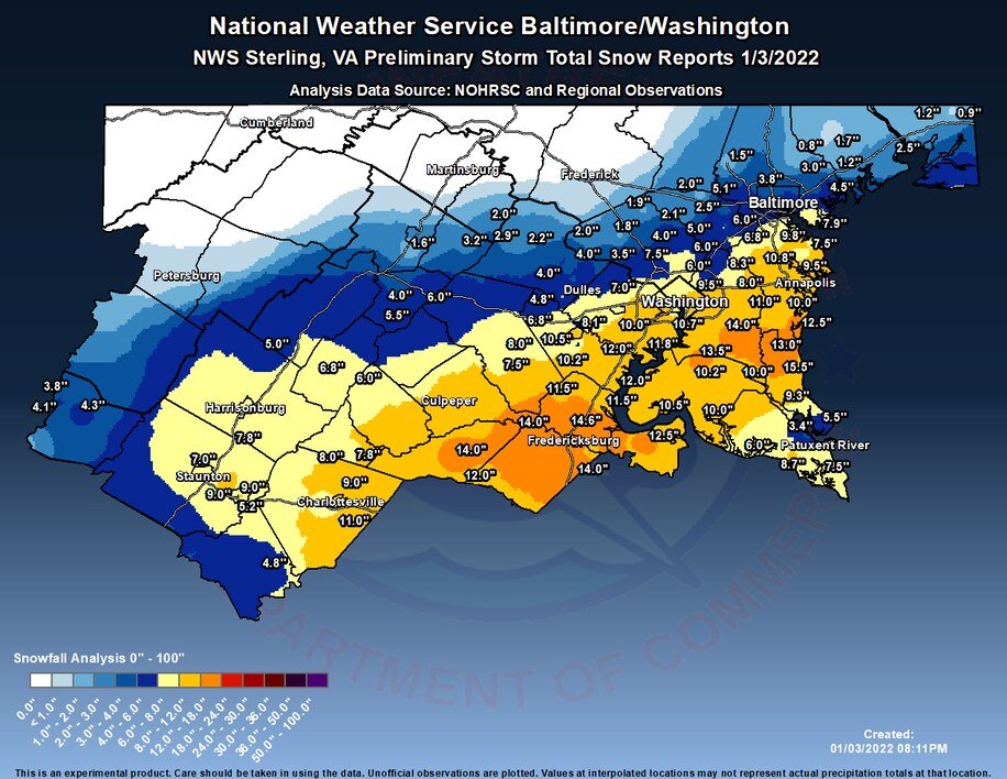
Six years ago, the DC region was absolutely buried by the Snowzilla storm with 18-36" of snow. Quite a few spots in our western areas entered the 30" club from this storm. This collection of photos showcased some of the most phenomenal scenes: wapo.st/39RQlWe
EVENING update: Snow Thurs AM still on track. Rain changing to snow 6 to 9a, with potential for heavy burst 8-10a. A quick inch or two poss and, with roads not being pretreated due to rain, maybe some slick spots. More info here: wapo.st/3KoFp3O (1/3)
There is some chance that this is not a big deal in some areas. Some models, like the Euro, indicate it won't snow hard enough for temps to drop and for much accumulation. But other models shows impressive burst (2/3)
Our general advice is to plan to avoid commuting in the morning if possible, esp between about 8 and 11a, but to of course check conditions and our updates for the latest. (3/3)
In-depth-- why Monday's snowstorm was so severe: wapo.st/3ERXyTF ... Thread follows...
The impact of Monday's storm can really be tied to: 1) its intensity and track, perfect for walloping central Va, S Md and DC with high snowfall rates and wind 2) the heavy, wet nature of the snow, which caused thousands of tree limbs to snap
Here's how much snow fell...but it wasn't the amount of snow that fell that made this storm so bad, but how quickly it fell -- at 1-3" per hour for several hours from DC south.
CWG's detailed outlook for Monday snow event... These amounts * could * be conservative. Thread to follow... wapo.st/3pK9B15
As usual, very challenging forecast as there will be sharp cutoff in heavy snow...probably somewhere between Beltway and northern Maryland. Model forecast for DC range from 1-2 inches on low end and over a foot on high end. We're taking middle ground.
Yes, some reliable models are showing double digit totals in DC area... but keep in mind these models wrongly assume all snow that falls will stick and sometimes overdo amounts...so we have to adjust for that. Here is the raw, unadjusted model forecasts:
Exceptional warmth spreading into the Central U.S. with some places seeing temperatures 30-35 degrees above normal Wednesday and Thursday: wapo.st/3lpySuV 1/x
Dozens of record highs are set to be broken the next two afternoons. Many parts of the central U.S. seeing highs well into the 60s and 70s. 2/x
Where's the snow? There's hardly any of it. Just 10 percent of nation has snow cover, second lowest on record for Dec. 1 (since 2003). Mountain snowpack is well below normal over most of West. 3/x
DC winter outlook THREAD: First, let's share our snowfall map--these are our predicted amounts for the ENTIRE winter. While not particularly impressive, they would beat last winter's totals: 1/x
An important note on the snowfall forecast: While we're predicting below-average amounts for the 5th time in the past 6 winters, it would just take one blockbuster storm to surpass it. The thing is though, La Ninas - which we have this year - lower the odds of a big snow. 2/x
During La Ninas, winter storms tend to track to our west, drawing in mild air from the south. So we can get some snow, but usually in modest amounts before it changes to ice and rain. 3/x
Powerful storm off Pac Northwest coast (yes, another bomb cyclone) has driven heavy rain, mountain snow into northern Calif to Washington. It's also catalyst for storm that will develop in Plains with snow/high winds in Dakotas, N Minnesota late week. wapo.st/3khWqRF 1/x
Pacific Northwest really getting hammered with precipiation--this is very typical of La Ninas. Map here is forecast precip through Friday morning: 2/x
As storm develops in northern Plains/Upper Midwest, heavy snow and strong winds likely to be big issue for northeast North Dakota and northern Minnesota, Thursday night and Friday - specific amounts still coming into focus. La Nina also favors harsh winter in this area: 3/x