
#ExtremeWeather Update:
The JTWC @USNavy run portal for Global surveillance/tracking of dangerous cyclones - seems to be out of action, inaccessible via the web, again.
Just as a third tropical storm is making landfall on Madagascar in the space of a month. @USNRL @WMO
The JTWC @USNavy run portal for Global surveillance/tracking of dangerous cyclones - seems to be out of action, inaccessible via the web, again.
Just as a third tropical storm is making landfall on Madagascar in the space of a month. @USNRL @WMO
https://twitter.com/althecat/status/1493567683412987906
The Joint Typhoon Warning Center website is here >> metoc.navy.mil/jtwc/jtwc.html
It has been unreliable for several months normally it looks like the 2nd image here below (image src: cyclocane.com - which aggregates cylone/storm data)
It has been unreliable for several months normally it looks like the 2nd image here below (image src: cyclocane.com - which aggregates cylone/storm data)


Tropical Depression 96S (see previous tweet) is the storm that is currently forecast by most models to develop into a dangerous cyclone threatening Madagascar and possibly SE Africa.
The storm was removed from the watch list yesterday morning - then reinstated this afternoon.
The storm was removed from the watch list yesterday morning - then reinstated this afternoon.
Note that this is not a cyclone, or even close to becoming one yet and initially I was wondering whether the reason it had been removed was that it had been determined to no longer be a storm of interest. But as the JTWC is not accessible it was/is impossible to find out.
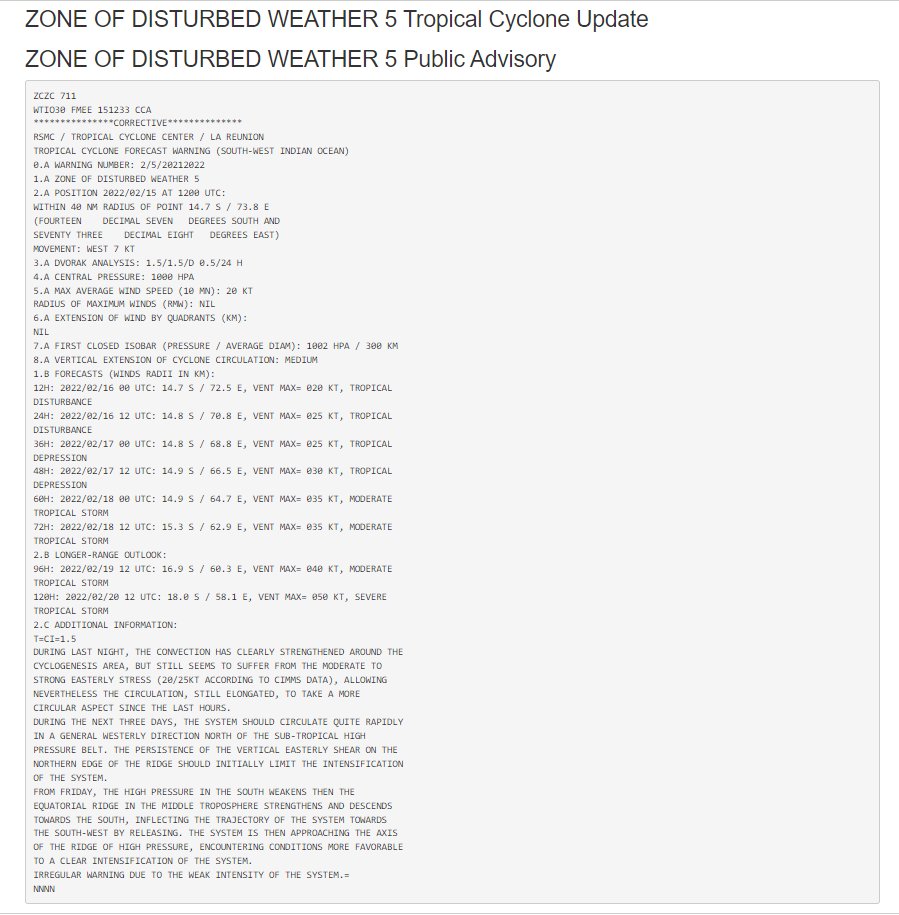
A short time ago a new advisory was issued - by the RSMC Tropical Cyclone Center on Reunion. It ends "IRREGULAR WARNING DUE TO THE WEAK INTENSITY OF THE SYSTEM.= NNNN"
And it would appear that on the basis of this warning that the disturbance is now being tracked again. Though at this point JTWC track forecast - which would normally be expected.
@meteofrance has also now issued a track forecast. [See... cyclocane.com/5-storm-tracke…]
@meteofrance has also now issued a track forecast. [See... cyclocane.com/5-storm-tracke…]

As mentioned before. This is not yet a cyclone and may not become one.
But four different simulation model forecasts still currently think it will, which is what made the decision to "un-designate" it appear a bit odd.
But four different simulation model forecasts still currently think it will, which is what made the decision to "un-designate" it appear a bit odd.


Especially since on the basis of the most reliable of the tropical model forecasts - from the US @NOAA GFS model - the storm has a very hazardous trajectory and threatens at present to be similar and possibly even stronger than cyclone #Batsirai.
And had this storm been in the Eastern Pacific and/or the Tropical Atlantic, based on my observations of @NHC hurricane surveillance, there is no way at all that it would have been un-designated.
That said, as you can see here the JTWC could well be right about #Invest96s. The storm definitely become less threatening overnight as it completed its merger with another storm #Invest93s. [image: CMISS]
Cyclone forecasting accuracy declines rapidly after 3 days (72 hours). Formation prediction is much harder.
@NOAA has a service for this, and in the case of this storm area these are the results. [See here >> ssd.noaa.gov/PS/TROP/TCFP/i…].
@NOAA has a service for this, and in the case of this storm area these are the results. [See here >> ssd.noaa.gov/PS/TROP/TCFP/i…].

In the Atlantic this information is turned by the @NHC into a probability of formation graphic over 24 hours, 48 hours or 5 days. It would be very interesting to know whether this data would be sufficient for such a warning.

The designation or not of a disturbance, depression or low as an #Invest clearly has budgetary and resource implications, (you can see this from the name), and it also has implications for the surveillance activity - by satellites.
The track forecasts provided by the JTWC are used by satellites to task satellite "floater" data stream to monitor weather systems of interest. The open data forecasting product from this is syndicated and ingested into models.

One of the automated services that aggregates this information (and which is very helpful at present while #JTWCisBorked) is cyclocane.com.
Before and after pictures.
Before and after pictures.


^^ these are before and after #Invest93s un-designation and re-designation. And because of that these pages are also live.
Left: cyclocane.com/5-storm-tracke…
Right: cyclocane.com/5-spaghetti-mo…
Left: cyclocane.com/5-storm-tracke…
Right: cyclocane.com/5-spaghetti-mo…


I am guessing here, but I suspect that the reason there is no spaghetti/intensity map yet for #Invest96s is that the storm was un-designated, i.e. the behind the scenes processes which produce these prediction engines were stopped.
Here is the European @ECMWF model spaghetti.
Here is the European @ECMWF model spaghetti.

And here is a recent model run from the @ECMWF of what it expects will happen with Precipitable Water in the South Indian Ocean Zone.
This area remains the most dangerous area in the world for Tropical Cyclones.
This area remains the most dangerous area in the world for Tropical Cyclones.
At #COP26 and since by the @WMO there has been a lot of talk of upgrading weather warning systems for the rest of the world - as doing so would doubtless be the most efficient way to spend adaptation funds available.
public.wmo.int/en/media/news/…
public.wmo.int/en/media/news/…
And better data and understanding of the changing climate which could be expected from such investment would also be useful for the specification/design of adequate physical defences against extreme weather.
But as of right now it appears we have a fair distance to go.
The website for what is arguably the single most important existing global weather early warning system the @USNavy's Joint Typhoon Warning Center [metoc.navy.mil/jtwc/jtwc.html] remains unavailable.
The website for what is arguably the single most important existing global weather early warning system the @USNavy's Joint Typhoon Warning Center [metoc.navy.mil/jtwc/jtwc.html] remains unavailable.
As for the un-designation of #Invest96s. There are two possible causes.
1. An active decision by the JTWC
2. It being a result of what ever the cause is of the website outage.
1. An active decision by the JTWC
2. It being a result of what ever the cause is of the website outage.
From what I can tell during the period when there was no track forecast for #Invest96S the satellite tasked with monitoring the storm @eumetsat did not stop monitoring, but just monitored a stationary point marked with the cross.
Meanwhile the storm moved 250 miles west.
Meanwhile the storm moved 250 miles west.

The @TropicalTidbits website appears to have stopped receiving data for #Invest96s at 2.30am GMT, and stopped updating. The error message here is interesting though. And the website still has not updated. tropicaltidbits.com/sat/

The excellent CMISS (Cooperative Institute for Meteorological Satellite Studies) website was also monitoring the wrong spot in the Indian Ocean for several hours (the Captal I on the right) rather than the circled blob. tropic.ssec.wisc.edu/#

And so was the US Naval Research Laboratory @USNRL nrlmry.navy.mil/TC.html
1. The area being monitored for most of the morning.
2. The image following the reinstatement of tracking data
3. The latest image.
1. The area being monitored for most of the morning.
2. The image following the reinstatement of tracking data
3. The latest image.


To conclude. Three animations of what the #Invest96s looks like now. The storm appears to be undergoing an intense transformation, perhaps as a result of the ingestion of #Invest93s.
1. A 6hr hour visual animation from @zoom_earth.
1. A 6hr hour visual animation from @zoom_earth.
2. A Satellite Infra Red + Water Vapour animation from CMISS (tropic.ssec.wisc.edu)
And finally the same as above showing intense areas of water vapour, but adding 700-850hpa wind layer lines (steering winds from around 2000-4000 meters).
• • •
Missing some Tweet in this thread? You can try to
force a refresh


