1/x
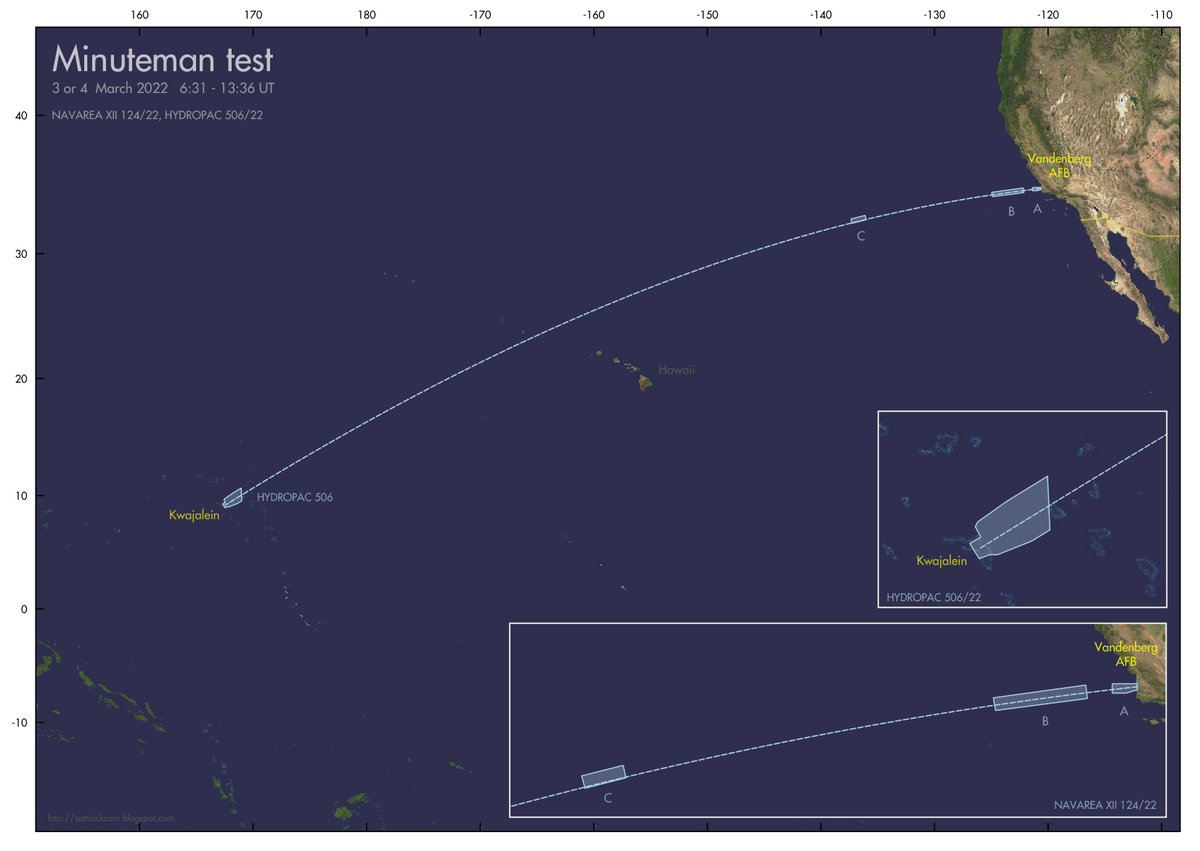
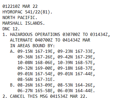
Navigational Warnings have appeared that suggest a #test launch of a #Minuteman #ICBM from Vandenberg on March 3 - 4.
(I suspect 1 or 2 more NavWarnings to appear for areas around Kwajalein, based on previous tests)
@nukestrat @mhanham @wslafoy @ArmsControlWonk

Navigational Warnings have appeared that suggest a #test launch of a #Minuteman #ICBM from Vandenberg on March 3 - 4.
(I suspect 1 or 2 more NavWarnings to appear for areas around Kwajalein, based on previous tests)
@nukestrat @mhanham @wslafoy @ArmsControlWonk

2/x
To be clear (as such suggestions always arrise):
This has *nothing* to do with the Ukraine crisis. Tests like these are scheduled months in advance.
They are regular tests to ascertain the readiness and training of missile crews.
To be clear (as such suggestions always arrise):
This has *nothing* to do with the Ukraine crisis. Tests like these are scheduled months in advance.
They are regular tests to ascertain the readiness and training of missile crews.
3/x
As I expected, another Navigational Warning has appeared, adding an extra hazard area west of Kwajalein.
Updated map for this upcoming #Minuteman III test (probably GT240GM):

As I expected, another Navigational Warning has appeared, adding an extra hazard area west of Kwajalein.
Updated map for this upcoming #Minuteman III test (probably GT240GM):

4/x
In terms of what these hazard zones represent, this is my interpretation (but I am open to informed suggestions otherwise):
In terms of what these hazard zones represent, this is my interpretation (but I am open to informed suggestions otherwise):

5/x
Some interesting OSINT sleuthing with the help of @wslafoy at the moment.
Basically, documents suggest the RV impact either at Illeginni Island on the Kwajalein Atol, or in deep Ocean *east* of it. The 3rd stage and PB vehicle should end up *east* of Kwajalein as well.
Some interesting OSINT sleuthing with the help of @wslafoy at the moment.
Basically, documents suggest the RV impact either at Illeginni Island on the Kwajalein Atol, or in deep Ocean *east* of it. The 3rd stage and PB vehicle should end up *east* of Kwajalein as well.
6/x
So the area *west* of Kwajalein remains a bit of a mystery.
Also, going back to previous Minuteman III test I've mapped, quite some variation in areas around Kwajalein.
So the area *west* of Kwajalein remains a bit of a mystery.
Also, going back to previous Minuteman III test I've mapped, quite some variation in areas around Kwajalein.
8/x
New developments:
New developments:
https://twitter.com/lmartinezabc/status/1499115343087820809
• • •
Missing some Tweet in this thread? You can try to
force a refresh


