1/30
A Thread on ownership of public lands in Secunderabad Cantonment - in the context of recent statements by @TelanganaCMO and Minister MAUD @KTRTRS on Cantonment issues.
A Thread on ownership of public lands in Secunderabad Cantonment - in the context of recent statements by @TelanganaCMO and Minister MAUD @KTRTRS on Cantonment issues.

2/30
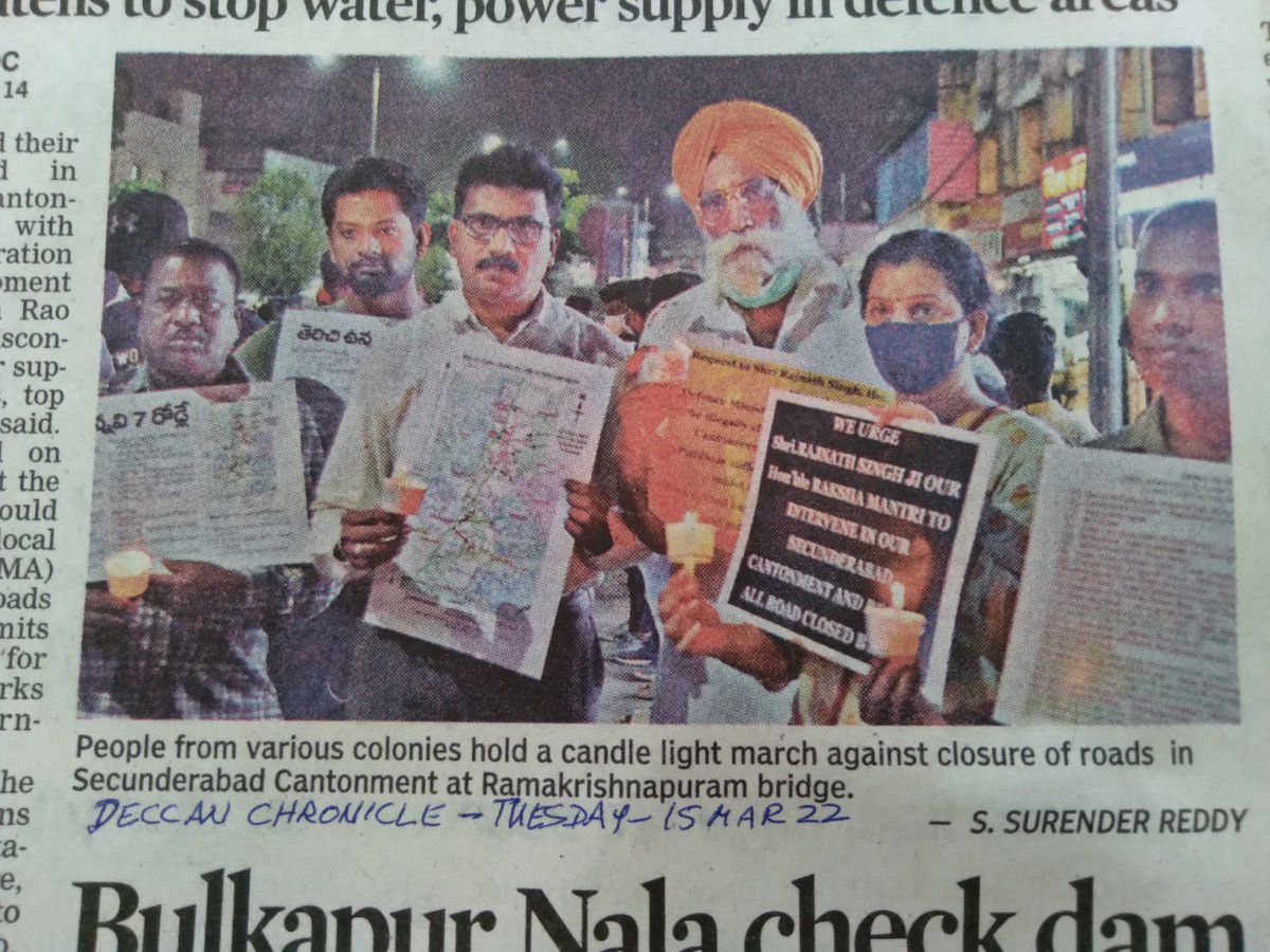
Speaking in State Assembly, #Telangana Min MAUD K T Rama Rao @KTRTRS strongly criticised hurdles being placed in developing nalas in military areas of the twin cities.
He also criticised road closures by the Army in Secunderabad Cantonment.
timesofindia.indiatimes.com/city/hyderabad…
Speaking in State Assembly, #Telangana Min MAUD K T Rama Rao @KTRTRS strongly criticised hurdles being placed in developing nalas in military areas of the twin cities.
He also criticised road closures by the Army in Secunderabad Cantonment.
timesofindia.indiatimes.com/city/hyderabad…
3/30
The next day Chief Minister K Chandrashekhar Rao @TelanganaCMO claimed in the Assembly that public lands in the cantonment and military areas are owned by Telangana State.
The next day Chief Minister K Chandrashekhar Rao @TelanganaCMO claimed in the Assembly that public lands in the cantonment and military areas are owned by Telangana State.
https://twitter.com/anarchist_vs/status/1502896953104863241?t=_rTAprLdxnrVTED25Df7Cg&s=08
4/30
The question of ownership of public land in Secunderabad has bearing on the resolution of several pressing public issues.
These include:
- Civilians being denied use of public roads through cantonment by military authorities.
@DeccanChronicle @oratorgreat
The question of ownership of public land in Secunderabad has bearing on the resolution of several pressing public issues.
These include:
- Civilians being denied use of public roads through cantonment by military authorities.
@DeccanChronicle @oratorgreat
5/30
- Impossible financial demands made by Centre when State approached it for land for road widening
- Lack of infrastructure development due to paucity of land, which contributes to the growing public demand for merger of cantonment with Greater Hyderabad Municipal Corporation
- Impossible financial demands made by Centre when State approached it for land for road widening
- Lack of infrastructure development due to paucity of land, which contributes to the growing public demand for merger of cantonment with Greater Hyderabad Municipal Corporation
7/30
The claim certainly goes against “traditional” wisdom.
Central Government (Min of Defence) administers all cantonments under Cantonments Act, and it is generally assumed that public lands in cantonments belong to it.
indiacode.nic.in/bitstream/1234…
The claim certainly goes against “traditional” wisdom.
Central Government (Min of Defence) administers all cantonments under Cantonments Act, and it is generally assumed that public lands in cantonments belong to it.
indiacode.nic.in/bitstream/1234…
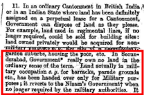
8/30
So what makes Secunderabad different?
For one, other cantonments were located in British India before 1947.
British had conquered these lands, or had otherwise got their ownership. So when they left in 1947 land ownership in those cantonments passed to Government of India
So what makes Secunderabad different?
For one, other cantonments were located in British India before 1947.
British had conquered these lands, or had otherwise got their ownership. So when they left in 1947 land ownership in those cantonments passed to Government of India
9/30
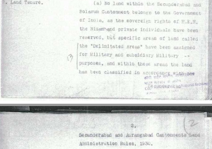
But Secunderabad and Aurangabad Cantonments were part of a sovereign princely state prior to 1948.
Public lands in Secunderabad were never owned by the British.
How do we know this?
But Secunderabad and Aurangabad Cantonments were part of a sovereign princely state prior to 1948.
Public lands in Secunderabad were never owned by the British.
How do we know this?
10/30
Well, British troops came to Hyderabad because of a Treaty between the 2nd Nizam and the British.
This Treaty bound each party to provide troops to the other in wars against common enemies.
Well, British troops came to Hyderabad because of a Treaty between the 2nd Nizam and the British.
This Treaty bound each party to provide troops to the other in wars against common enemies.
11/30
As a consequence to the Treaty the British placed a “Subsidiary Force” of troops was in Hyderabad.
Nizam allocated space near Hussain Sagar (today's Kavadiguda) for these troops to stay.
As a consequence to the Treaty the British placed a “Subsidiary Force” of troops was in Hyderabad.
Nizam allocated space near Hussain Sagar (today's Kavadiguda) for these troops to stay.
12/30
The place drew traders from all over India who came to provide goods and services to the troops.
The new town which emerged was named Secunderabad in 1806, after the 3rd Nizam, Sikandar Jah.
The place drew traders from all over India who came to provide goods and services to the troops.
The new town which emerged was named Secunderabad in 1806, after the 3rd Nizam, Sikandar Jah.
13/30
The Treaty also bound Nizam to provide troops to the British. However, claiming that Nizam's troops were poorly trained, British raised a new contingent of local troops at Nizam's expense.
This “Hyderabad Contingent” was quartered in Bolarum, 10 km north of Secunderabad.
The Treaty also bound Nizam to provide troops to the British. However, claiming that Nizam's troops were poorly trained, British raised a new contingent of local troops at Nizam's expense.
This “Hyderabad Contingent” was quartered in Bolarum, 10 km north of Secunderabad.
14/30
Here then, is the crux.
Though Nizam allowed British to occupy land for military purposes there is ample evidence to demonstrate that he did not give them ownership of the land.
Here then, is the crux.
Though Nizam allowed British to occupy land for military purposes there is ample evidence to demonstrate that he did not give them ownership of the land.
15/30
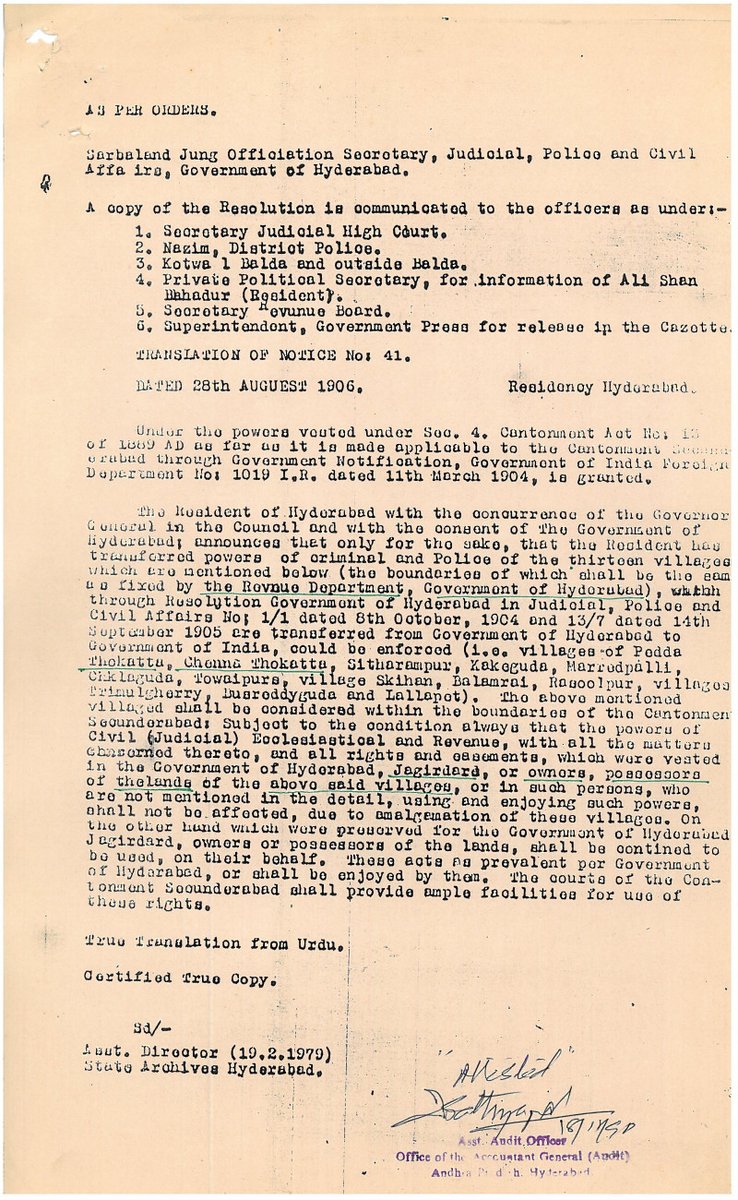
Consider:
- In 1906, Bolarum, Secunderabad and 13 villages were merged to form the entity now called Secunderabad”.
The firman formalising this Nizam clearly states that land ownership remained with original owners.
Consider:
- In 1906, Bolarum, Secunderabad and 13 villages were merged to form the entity now called Secunderabad”.
The firman formalising this Nizam clearly states that land ownership remained with original owners.
16/30
- The British undertook several exercises to verify if they owned any land in Secunderabad.
The most elaborate such exercise was by Sir William Barton in 1926.
All these exercises concluded that British did not own any land in Secunderabad.
- The British undertook several exercises to verify if they owned any land in Secunderabad.
The most elaborate such exercise was by Sir William Barton in 1926.
All these exercises concluded that British did not own any land in Secunderabad.
17/30
- In 1933 the British prepared the first comprehensive land record of Secunderabad.
Capt C M James, the Officer appointed for preparing this “General Land Register (GLR)”, stated that British did not own any land in Secunderabad
- In 1933 the British prepared the first comprehensive land record of Secunderabad.
Capt C M James, the Officer appointed for preparing this “General Land Register (GLR)”, stated that British did not own any land in Secunderabad
18/30
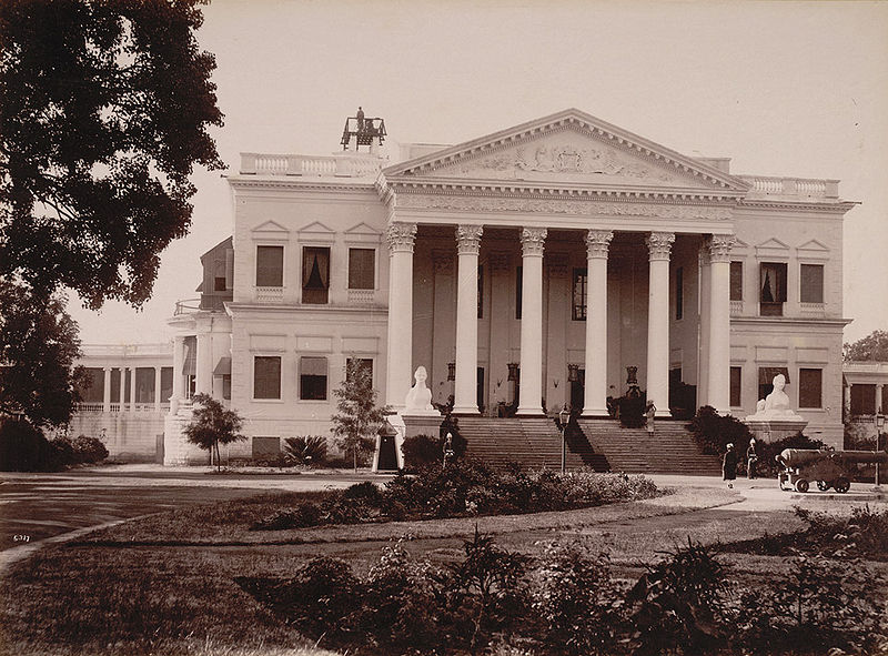
Twice Nizam took back land which was no longer required for military purpose.
- First was when he took back Chaderghat Municipality, including the Residency itself (Koti Women's College of today), in 1933.
(bl.uk/onlinegallery/…)
Twice Nizam took back land which was no longer required for military purpose.
- First was when he took back Chaderghat Municipality, including the Residency itself (Koti Women's College of today), in 1933.
(bl.uk/onlinegallery/…)
19/30
- Second time was when he took back the town area of Secunderabad (south of RP Rd of today) in 1946.
Numerous archival documents support the above assertions.
- Second time was when he took back the town area of Secunderabad (south of RP Rd of today) in 1946.
Numerous archival documents support the above assertions.
20/30
So if British did not own the land, who owned it?
Most of Hyderabad's land (not just cantonment) - about 80,000 sq km (out of the state's total area of 2,10,000 sq km) - was owned by Nizam himself, Directly (sarf-e-khas lands) or indirectly through paigahs and jagirdars.
So if British did not own the land, who owned it?
Most of Hyderabad's land (not just cantonment) - about 80,000 sq km (out of the state's total area of 2,10,000 sq km) - was owned by Nizam himself, Directly (sarf-e-khas lands) or indirectly through paigahs and jagirdars.
21/30
There was some diwani land (belonging to Hyderabad Government). The rest was privately owned.
Peasant oppression by aristocracy led to a violent peasants' revolt in the 1940s. This revolt was still ongoing in 1948 when Indian Army under Gen JN Chowdhary entered Hyderabad.
There was some diwani land (belonging to Hyderabad Government). The rest was privately owned.
Peasant oppression by aristocracy led to a violent peasants' revolt in the 1940s. This revolt was still ongoing in 1948 when Indian Army under Gen JN Chowdhary entered Hyderabad.
22/30
To tackle the revolt, equitable land distribution was a must.
Ministry of States under Sardar Patel instructed Maj Gen J N Chaudhuri (appointed Governor after he led Indian Army into Hyderabad) to convince Nizam to hand over sarf-e-khas and jagir lands to the State.
To tackle the revolt, equitable land distribution was a must.
Ministry of States under Sardar Patel instructed Maj Gen J N Chaudhuri (appointed Governor after he led Indian Army into Hyderabad) to convince Nizam to hand over sarf-e-khas and jagir lands to the State.
23/30
It is clear from the account of these negotiations available in the National Archives there were tortuous and protracted negotiations between the two.
The Privy Purse offered to Nizam was enhanced. Other concessions were made.
It is clear from the account of these negotiations available in the National Archives there were tortuous and protracted negotiations between the two.
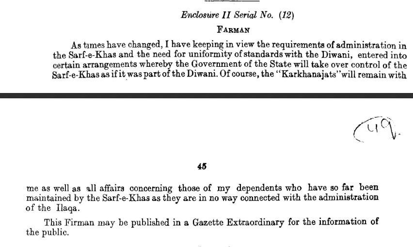
The Privy Purse offered to Nizam was enhanced. Other concessions were made.
24/30
Finally Nizam agreed to hand over these lands to the State.
This was formalised by passing two Regulations in 1358 Fasli (1949 AD) – “Hyderabad Sarf-e-Khas (Merger) Regulation” and “Hyderabad (Abolition of Jagirs) Regulation”.
Finally Nizam agreed to hand over these lands to the State.
This was formalised by passing two Regulations in 1358 Fasli (1949 AD) – “Hyderabad Sarf-e-Khas (Merger) Regulation” and “Hyderabad (Abolition of Jagirs) Regulation”.
25/30
Overnight, 80,000 sq km of land owned by the aristocracy thus became "Diwani", or state land.
This land could be distributed equitably by the first elected government of the state.
It was perhaps the largest single land reform in independent India.
Overnight, 80,000 sq km of land owned by the aristocracy thus became "Diwani", or state land.
This land could be distributed equitably by the first elected government of the state.
It was perhaps the largest single land reform in independent India.
26/30
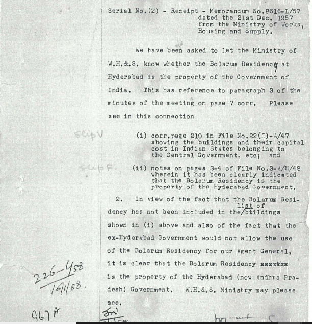
Subsequent to Hyderabad's merger with India Govt of India had to purchase Rashtrapathi Nilayam (erstwhile Bolarum Residency) from the then AP Govt.
This shows that despite being the erstwhile seat of the British in Hyderabad, the premises had belonged to State Government.
Subsequent to Hyderabad's merger with India Govt of India had to purchase Rashtrapathi Nilayam (erstwhile Bolarum Residency) from the then AP Govt.
This shows that despite being the erstwhile seat of the British in Hyderabad, the premises had belonged to State Government.
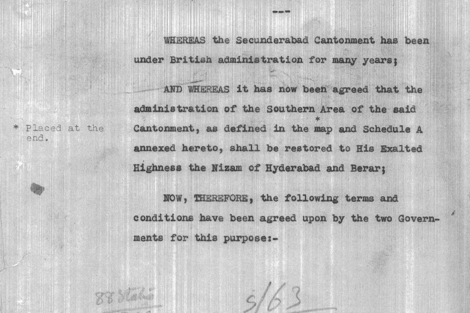
27/30
Also, there have been several cases where courts have rejected Govt of India's claim to land in Secunderabad cantonment.
There have also been Resolutions of the Cantonment Board stressing the different history of land ownership in Secunderabad as compared to other cantts.
Also, there have been several cases where courts have rejected Govt of India's claim to land in Secunderabad cantonment.
There have also been Resolutions of the Cantonment Board stressing the different history of land ownership in Secunderabad as compared to other cantts.
28/30
Among the lands that became Diwani (State Lands) in 1948 were Jagir and sarf-e-khas lands inside Secunderabad Cantonment.
It is clear therefore that unlike in other cantonments, in Secunderabad the State is the owner of public lands in Cantonment.
Among the lands that became Diwani (State Lands) in 1948 were Jagir and sarf-e-khas lands inside Secunderabad Cantonment.
It is clear therefore that unlike in other cantonments, in Secunderabad the State is the owner of public lands in Cantonment.
29/30
The facts therefore seems to support @TelanganaCMO claim that land in Secunderabad Cantonment belongs to the state.
The facts therefore seems to support @TelanganaCMO claim that land in Secunderabad Cantonment belongs to the state.
30/30
Reference: National Archives of India
All copyrights acknowledged
Reference: National Archives of India
All copyrights acknowledged
@threadreaderapp unroll
• • •
Missing some Tweet in this thread? You can try to
force a refresh