1/14
The effect of the ongoing floods in Hyderabad, triggered by excessive rainfall events, has been amplified by the havoc played with the city's lakes and nallas.
This thread attempts to explain why the havoc occurred.
The effect of the ongoing floods in Hyderabad, triggered by excessive rainfall events, has been amplified by the havoc played with the city's lakes and nallas.
This thread attempts to explain why the havoc occurred.
2/14
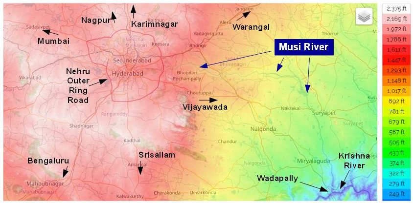
This map shows the topography of Hyderabad's surroundings.
It also traces the Musi River from the 1500-2000 ft ASL elevation of Hyderabad to 200-250 ft at its confluence with the Krishna at Wadapally on the Telangana - AP border. .
(Ref: en-gb.topographic-map.com/maps/lppp/Hyde…)
This map shows the topography of Hyderabad's surroundings.
It also traces the Musi River from the 1500-2000 ft ASL elevation of Hyderabad to 200-250 ft at its confluence with the Krishna at Wadapally on the Telangana - AP border. .
(Ref: en-gb.topographic-map.com/maps/lppp/Hyde…)
3/14
It is obvious that the terrain in this part of the Deccan Plateau slopes rather steeply from west to east.
It is obvious that the terrain in this part of the Deccan Plateau slopes rather steeply from west to east.
4/14
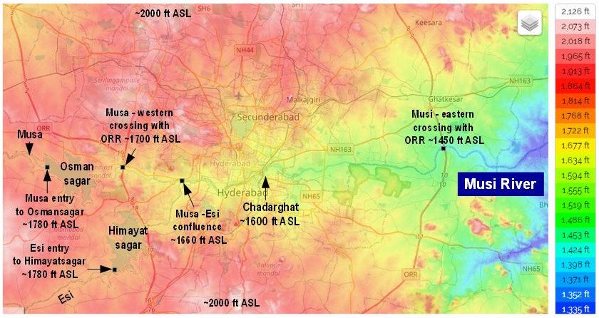
Let us follow the Musi through the city.
Musa is Musa + Esi.
Both Musa and Esi enter their respective holding reservoirs - Osmansagar and Himayatsagar - at identical elevations of ~1780 ft ASL.
Musa emerges from Osmansagar and crosses Outer Ring Road at ~1700 ft ASL
Let us follow the Musi through the city.
Musa is Musa + Esi.
Both Musa and Esi enter their respective holding reservoirs - Osmansagar and Himayatsagar - at identical elevations of ~1780 ft ASL.
Musa emerges from Osmansagar and crosses Outer Ring Road at ~1700 ft ASL
5/14
The confluence of Musa and Esi occurs at ~1660 ft ASL and forms the Musi.
Musi then flows through the city and crosses the eastern periphery of ORR at ~1450 ft ASL.
Thus it drops about 250 feet between the western and eastern peripheries of ORR.
The confluence of Musa and Esi occurs at ~1660 ft ASL and forms the Musi.
Musi then flows through the city and crosses the eastern periphery of ORR at ~1450 ft ASL.
Thus it drops about 250 feet between the western and eastern peripheries of ORR.
6/14
Maximum elevations in the north and south extremities of the city are in excess of 2000 ft ASL.
The terrain slopes down to the Musi from there, dropping as much as 400 ft at, say, Chadarghat (which is 1600 ft ASL).
Maximum elevations in the north and south extremities of the city are in excess of 2000 ft ASL.
The terrain slopes down to the Musi from there, dropping as much as 400 ft at, say, Chadarghat (which is 1600 ft ASL).
7/14
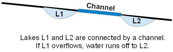
At many places in this north-south slope there are depressions. These allow lakes to form.
Channels existed between lakes at higher levels to the lower ones. This allowed overflow from higher lakes to be accommodated in lower ones.
At many places in this north-south slope there are depressions. These allow lakes to form.
Channels existed between lakes at higher levels to the lower ones. This allowed overflow from higher lakes to be accommodated in lower ones.
8/14
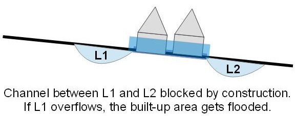
Over time many of these channels were blocked by rampant construction to house the city's growing population.
Many lakes themselves were filled up.
So now, when a higher lake overflows, it floods constructed areas on its way to lower levels.
Over time many of these channels were blocked by rampant construction to house the city's growing population.
Many lakes themselves were filled up.
So now, when a higher lake overflows, it floods constructed areas on its way to lower levels.
9/14
With this background let us see what caused the devastation in Balapur, Barkas and surrounding areas.
There are many lakes south of the Musi.
The ones farther away from the river are at higher elevations. The closer ones are lower.
With this background let us see what caused the devastation in Balapur, Barkas and surrounding areas.
There are many lakes south of the Musi.
The ones farther away from the river are at higher elevations. The closer ones are lower.
10/14
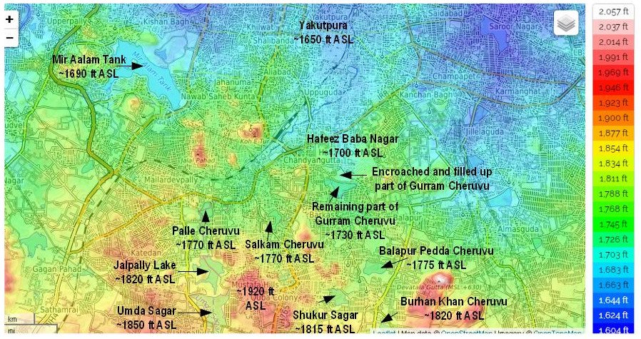
To explain the Balapur Disaster let us look some lakes.
The Umda Sagar - Jalpally Lake – Palle Cheruvu is a series of lakes which used to be interconnected.
A second such series was Burhan Khan Cheruvu - Shukur Sagar - Pedda Cheruvu - Salkam Cheruvu - Gurram Cheruvu.
To explain the Balapur Disaster let us look some lakes.
The Umda Sagar - Jalpally Lake – Palle Cheruvu is a series of lakes which used to be interconnected.
A second such series was Burhan Khan Cheruvu - Shukur Sagar - Pedda Cheruvu - Salkam Cheruvu - Gurram Cheruvu.
11/14
The outlet from Palle Cheruvu, the lowest of the first series of lakes, connects to the outlet of Gurram Cheruvu, the lowest of the second series.
Gurram Cheruvu itself is encroached, as marked in the map. It's northern part has been filled up.
The outlet from Palle Cheruvu, the lowest of the first series of lakes, connects to the outlet of Gurram Cheruvu, the lowest of the second series.
Gurram Cheruvu itself is encroached, as marked in the map. It's northern part has been filled up.
12/14
The channels connecting the lakes have also either been totally constructed over, or are heavily encroached.
The outlet of Gurram Cheruvu, the lowest in this system of lakes, is in fact almost totally blocked.
The channels connecting the lakes have also either been totally constructed over, or are heavily encroached.
The outlet of Gurram Cheruvu, the lowest in this system of lakes, is in fact almost totally blocked.
13/14
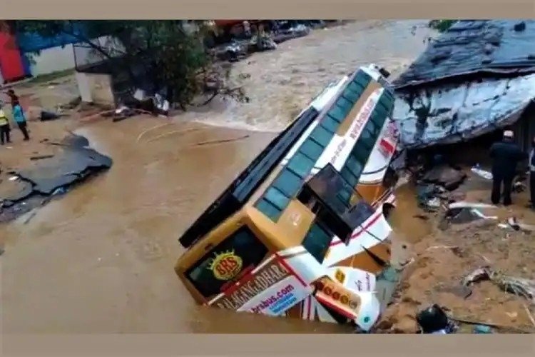
On 17 Oct the swollen Gurram Cheruvu burst its embankment, flooding Balapur, Barkas, Hafeez Baba Nagar, etc.
These areas, recovering from the downpour of 3 days ago, were plunged into another, heavier round of misery - triggered by rain, but amplified by encroachment.
On 17 Oct the swollen Gurram Cheruvu burst its embankment, flooding Balapur, Barkas, Hafeez Baba Nagar, etc.
These areas, recovering from the downpour of 3 days ago, were plunged into another, heavier round of misery - triggered by rain, but amplified by encroachment.
14/14
Preventing urban floods totally, is impossible.
But if the lakes are restored to their full tank level, and interconnecting channels of sufficient capacity ensured between them, the problem can be mitigated significantly.
It is a mammoth task, but worth undertaking.
Preventing urban floods totally, is impossible.
But if the lakes are restored to their full tank level, and interconnecting channels of sufficient capacity ensured between them, the problem can be mitigated significantly.
It is a mammoth task, but worth undertaking.
@threadreaderapp unroll
• • •
Missing some Tweet in this thread? You can try to
force a refresh