Durotriges Project Profile picture
Mar 16, 2022 13 tweets 15 min read Read on X
It's #HillfortsWednesday and here’s the curiously enigmatic (and infrequently examined) prehistoric earthwork enclosures atop the wonderfully named Thundersbarrow Hill #WestSussex @sdnpa 😍

Pic © CACUP 1975 (BSR60) @CamDigLib @theUL

A short thread 👇👇👇
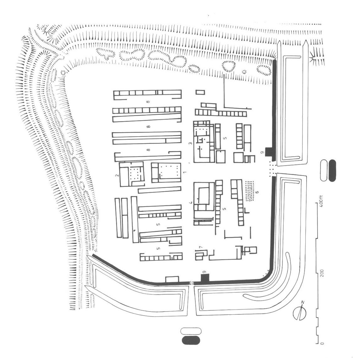
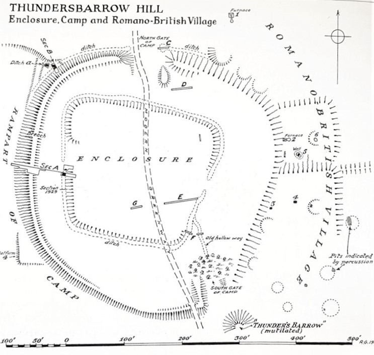
The subcircular Iron Age hillfort of Thundersbarrow covers 1.2ha with entrances at the SE and N

It encloses a 0.5ha subsquare Bronze Age enclosure with a barrow and Romano British village at the S + E

Plan: Robert Gurd 1932 © Sussex Arch Soc @sussex_society

#HillfortsWednesday
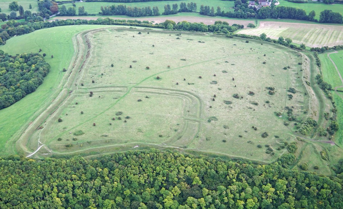
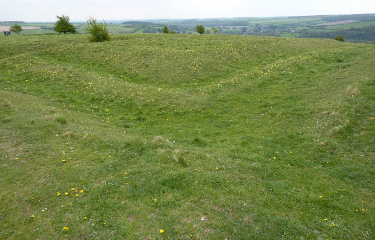
Thundersbarrow Early Iron Age hillfort sits brooding atop a low ridge at the southern slope of the chalk downs @sdnpa above the Sussex coastal plain and Shoreham-by-Sea

It's easy to spot once you know it's there

Pic Simon Carey 2005 CC BY-SA 2.0

#HillfortsWednesday
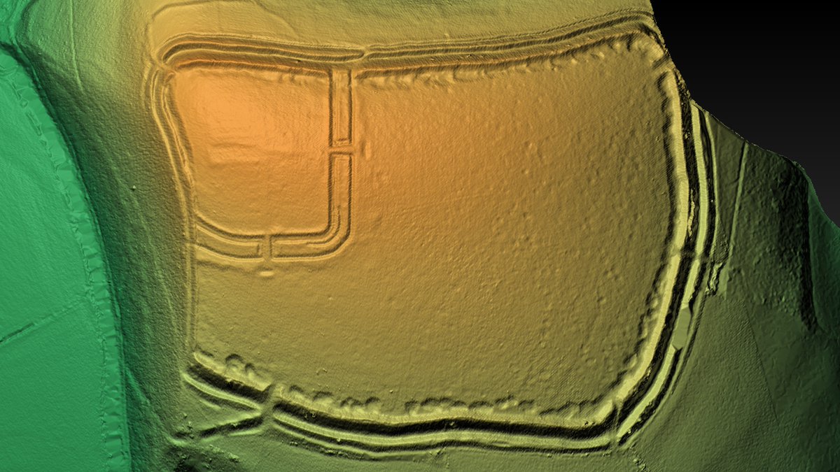
The landscape context of Thundersbarrow hillfort and its relationship to prehistoric, Romano British and later fieldsystems is evident in these contour and relief LiDAR maps looking SE generated by @planlaufterrain @HenryRothwell

See digitaldigging.net/thundersbarrow…

#HillfortsWednesday
The archaeology of Thundersbarrow Hill (a BA barrow, LBA enclosure, EIA hillfort and a RB village with field systems) was recorded in meticulous detail from 1916-32 by Robert Gurd, William Jacobs, Herbert Toms and EC Curwen, prior to plough damage 🤩

#HillfortsWednesday
The hillfort of Thundersbarrow has been levelled by ploughing at the E, but survives as a low earthwork along the W as evident in this aerial pic looking NE

The inner Bronze Age enclosure appears as a crop mark

Pic © CACUP 1975 (BSR58) @CamDigLib @theUL

#HillfortsWednesday
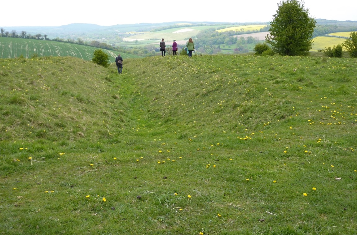
The western edge of Thundersbarrow hillfort #WestSussex, despite agricultural attrition, can just be made out today, the rampart surviving to just under 1m in height above a shallow 6m wide ditch

Pics Robin Webster / A R Cane CC BY-SA 4.0
#HillfortsWednesday
Excavations at Thundersbarrow by Elliot Cecil Curwen in 1932 sampled the Iron Age hillfort, Bronze Age enclosure and Romano British grain-drying / malting ovens identified through ground percussion

Robert Gurd was on hand to record them © @sussex_society

#HillfortsWednesday
In August 1985, excavations at Thundersbarrow hillfort #WestSussex were conducted by David Rudling on behalf of the Sussex Archaeological Field Unit @UCLarchaeology

It was fun (if cold) 👍

#HillfortsWednesday (early #ThrowbackThursday)
Excavations at Thundersbarrow Hill #WestSussex @UCLarchaeology August 1985 for #HillfortsWednesday and #ThrowbackThursday

As with all digs in the 80s, on-site facilities were a tad basic 😊

a) photographic tower 😱

b) accommodation 😱😱

c) something best not mentioned😱😱😱
Excavations in August 1985 across the barrow of ‘Thundersbarrow’ Hill #WestSussex confirmed it was indeed of Early Bronze Age date

#HillfortsWednesday
The 1985 excavation by David Rudling #SAFU @ArchSouthEast @UCLarchaeology across the inner enclosure at Thundersbarrow Hill confirmed this earlier phase dated to the Later Bronze Age (10th / 9th century BC)

The outer ditch was 3m wide and 0.6m deep

#HillfortsWednesday
Excavation by #SAFU (now @ArchSouthEast @UCLarchaeology) across the bank and outer ditch of Thundersbarrow Hill #WestSussex in 1985 recovered finds that suggesting the hillfort was constructed in the 6th c BC and went out of use in the mid-3rd c BC

Happy #HillfortsWednesday !

• • •

Missing some Tweet in this thread? You can try to force a refresh
 

Keep Current with Durotriges Project

Durotriges Project Profile picture

Stay in touch and get notified when new unrolls are available from this author!

Read all threads

This Thread may be Removed Anytime!

PDF

Twitter may remove this content at anytime! Save it as PDF for later use!

Try unrolling a thread yourself!

how to unroll video
  1. Follow @ThreadReaderApp to mention us!

  2. From a Twitter thread mention us with a keyword "unroll"
@threadreaderapp unroll

Practice here first or read more on our help page!

More from @Durotrigesdig

Aug 27, 2024
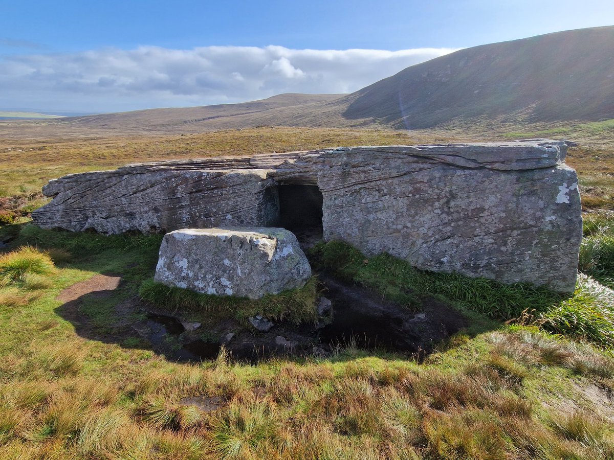
The enigmatic Dwarfie Stane on the island of #Hoy, part of the #Orkney archipelago

Looked after by @welovehistory @HistEnvScot it's quite possibly Britain's only #Neolithic rock cut tomb

A peedie thread for #TombTuesday

📷 Aug 2024 👇👇 Image
The Dwarfie Stane #Hoy is a chonky slab of red sandstone (measuring 2m high and 8m long) into which a 2 chambers linked by a short entrance passage have been carved

Plan: J Callander *Proceedings of the Society of Antiquaries of Scotland* 70 (1936)

#TombTuesday Image
Today, the Dwarfie Stane #Hoy can be freely accessed, a large blocking stone, which seems to have originally sealed the entrance, lies nearby

📷 August 2024

#TombTuesday
Image
Image
Read 6 tweets
Mar 2, 2022
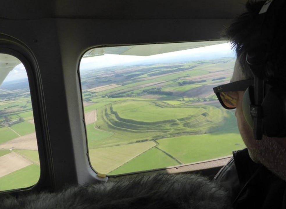
For #HillfortsWednesday here’s the glorious Chlorus Camp (Figsbury Ring) #Wiltshire, photographically captured by David R Abram 🤩

For more of his stunning work see davidabram.co.uk

And catch his exhibition @SalisburyMuseum salisburymuseum.org.uk/whats-on/exhib…

A thread 👇👇👇
Figsbury Ring / Chlorus Camp #Wiltshire comprises a univallate Iron Age hillfort with entrances at the East and West

At 6.2ha it encloses a Neolithic / EBA feature (a henge?)

LiDAR Digital terrain model Rouven Meidlinger @planlaufterrain CC BY-SA 4.0

#HillfortsWednesday
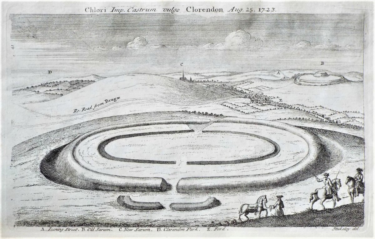
William Stukeley visited Chlorus Camp hillfort (Figsbury Ring) #Wiltshire in 1723

His drawing of the hillfort and inner henge looking SW shows the hillfort and castle of @EHOldSarum (B) and cathedral of Salisbury (C) in the distance

#HillfortsWednesday #HengeWednesday
Read 9 tweets
Feb 23, 2022
It’s #HillfortsWednesday (huzzah!)

Today we’re looking down on the mighty Maiden Castle #Dorset @EnglishHeritage

It's impressive today, but how did it look in prehistory?

A thread on our favourite recreations / reconstructions from books, guides and on-site signage 👇👇 ImageImageImage
Arguably the most famous hillfort in Britain, the multivallate Maiden Castle #Dorset encloses over 17ha and comprises many phases of construction and modification the appearance of which can be difficult to convey

📷 looking south © Jo and Sue Crane 2016

#HillfortsWednesday Image
The earliest built phase at Maiden Castle #Dorset was an Early Neolithic causewayed enclosure (c. 3550 BC)

Recreations of this period are comparatively rare, so this wonderful image © Miranda Schofield / English Heritage is particularly welcome 😊👍

#HillfortsWednesday Image
Read 25 tweets
Mar 31, 2021
It’s #HillfortsWednesday and we wonder if the Iron Age univallate Trundle has ever looked more gorgeous than in this incredible pic by @DavidRAbram here, looking N towards the mist swathed #WestSussex Weald 🤩

For more of David’s stunning photos see:

davidabram.co.uk/ancient-britain
The Iron Age ramparts of the Trundle #WestSussex partially enclose the spiral circuit of an earlier causewayed enclosure, the remains of which can be seen in this epic photo by @DavidRAbram

For more of David’s stunning photos see:

davidabram.co.uk/ancient-britain

#HillfortsWednesday
The distinctive imprint of a Neolithic causewayed enclosure is evident within the polygonal circuit of the Iron Age Trundle #WestSussex as slight earthworks and as dark lines to the SW in this early air photo from the 1930s in @SAS_Library @sussex_society

#HillfortsWednesday
Read 9 tweets
Oct 21, 2020
Figsbury Ring comprises a fine set of prehistoric enclosure systems on the chalk above Salisbury in #Wiltshire looked after by @nationaltrust @NatTrustArch

A short thread for #HillfortsWednesday
Figsbury Ring, once known as Chlorus Camp, #Wiltshire @NatTrustArch - The outer circuit encloses 6.2ha with entrances on the E and W

📷 Dae Sasitorn + Adrian Warren © Sasitorn Images

For more amazing images see: sasitornimages.com

#HillfortsWednesday
For many years, Figsbury Ring, depicted here in the Ordnance Survey for 1927 with the Roman road from Old Sarum to Winchester to the south, was thought to be a bivallate Iron Age hillfort...

...but there was something strange about the innermost circuit

#HillfortsWednesday
Read 9 tweets
Aug 5, 2020
Here’s the glorious multivallate Iron Age hillfort (and Roman fort) atop #HodHill #Dorset @nationaltrust 😍looking east in this aerial photo from 2016 © Jo and Sue Crane

A thread to celebrate #HillfortsWednesday
Double ramparts define the 22ha hillfort of Hod Hill #Dorset except on the W with a single bank. Quarry pits form a line behind the ramparts. A Roman fort occupies the NW

Digital terrain model planlauf/TERRAIN from @HenryRothwell digitaldigging.net/hod-hill-dorse…
#HillfortsWednesday
The 2.6ha Roman fort at Hod Hill dates to c AD 44-52. It reused the N and W ramparts of the hillfort and was defended on its S and E sides by a rampart and 3 ditches

Excavations in 1951-8 revealed much of the internal structure

#HillfortsWednesday
Read 12 tweets

Did Thread Reader help you today?

Support us! We are indie developers!


This site is made by just two indie developers on a laptop doing marketing, support and development! Read more about the story.

Become a Premium Member ($3/month or $30/year) and get exclusive features!

Become Premium

Don't want to be a Premium member but still want to support us?

Make a small donation by buying us coffee ($5) or help with server cost ($10)

Donate via Paypal

Or Donate anonymously using crypto!

Ethereum

0xfe58350B80634f60Fa6Dc149a72b4DFbc17D341E copy

Bitcoin

3ATGMxNzCUFzxpMCHL5sWSt4DVtS8UqXpi copy

Thank you for your support!

Follow Us!

:(