Daniel Swain Profile picture
Aug 12 21 tweets 14 min read
New work co-led by @xingyhuang and me on the rising risk of a California #megaflood due to #ClimateChange is out today in @ScienceAdvances! This paper also describes the new #ARkStorm2 scenarios in detail, & will be the basis for ongoing work. (Thread:1/n) science.org/doi/10.1126/sc…
For context: the work and findings presented here represent the first phase of the broader #ARkStorm2 project, a multi-year, cross-institutional effort involving multiple @UofCalifornia campuses, @DRIScience, @USGS, @CA_DWR, & @NCAR_Science. (2/n) science.org/doi/10.1126/sc…
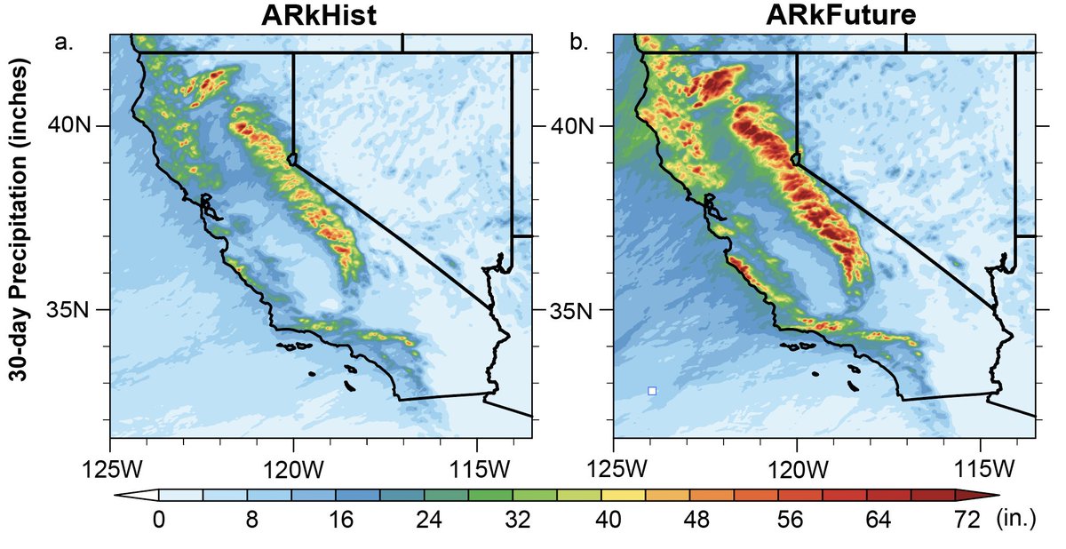
In this work, we develop a pair of plausible extreme, month-long winter storm sequences in California--one from the recent historical climate, and one from a much warmer future climate. These sequences involve a multi-week series of successive #AtmosphericRiver storms. (3/n)
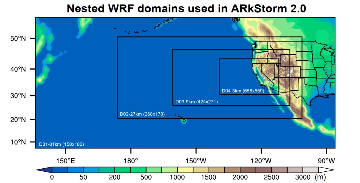
These scenarios are drawn from a climate model large ensemble (CESM-LENS), using a high-resolution weather model (WRF) embedded within climate model conditions to produce realistic "synthetic weather forecasts" in present and future climates. #CAwx science.org/doi/10.1126/sc… (4/n)
Both ARkHist & ARkFuture generate huge amounts of precipitation in California, but ARkFuture scenario is considerably wetter (45% so on a statewide basis, & locally 80% wetter). Some mountain areas see 30-day precip >60 inches in ARkHist, and >100 inches in ARkFuture! (5/n)
Interestingly, we find larger increases in daily/ hourly precipitation *intensities* than in overall amounts--suggesting that risk of flash flooding in smaller watersheds/urban areas, as well as debris flows, might increase more than river flood risk in warming climate. (6/n)
We also find dramatic changes in rain/snow balance in California's mountains during ARkFuture--in which most precip falls as rain (vs snow) at elevations as high as 5-6,000 feet. This has enormous implications for hydrology of watersheds draining historical snowsheds. (7/n)
Subsequently, we find very large increases in peak runoff during ARkFuture vs ARkHist: 60-100% higher statewide & locally 3-400% higher in Sacramento & (especially) San Joaquin basins as more precip falls overall & much greater fraction falls as rain.science.org/doi/10.1126/sc… (8/n)
We also consider the large-scale conditions that coincide with simulated California megafloods. Intriguingly, 8 of the 8 top events in present and future climates occur during warm ENSO (#ElNiño) conditions, and 7/8 during moderate to strong events. (9/n) science.org/doi/10.1126/sc…
Further, few if any of these #ElNiño events are east-based: they have a more Central Pacific focus (so-called #ElNiño Modoki). This has a couple of important implications... (10/n) science.org/doi/10.1126/sc…
First, it means that there may be seasonal predictability of risk--since there's a strong tilt toward moderate-strong #ElNiño years. Second, megafloods are more likely to occur in years with wet antecedent conditions--amplifying flood risk. (11/n) science.org/doi/10.1126/sc…
We also consider the role of #ClimateChange in increasing the risk of California megafloods. Large pluvials have, of course, occurred in California since time immemorial. But we find that climate change is sharply upping the odds. (12/n) #CAwx science.org/doi/10.1126/sc…
We find that #ClimateChange has already doubled the risk of a California megaflood (since 1920). Each half of a degree of additional global warming will lead to appreciable further increases in risk moving forward through the 21st century. #CAflood science.org/doi/10.1126/sc… (13/n)
It may seem a bit strange to be talking about rising risk of a California #megaflood amidst severe #CAdrought. But it's not as paradoxical as it might seem at first glance--a topic I discuss extensively in my new Weather West overview of our work: (14/n) weatherwest.com/archives/16626
Collectively, all of this suggests that California really needs to be planning for an increasing risk of catastrophic flooding--risk that was widely underestimated even absent climate change, but now those risks are rising further. (15/n) science.org/doi/10.1126/sc…
This research has been literally years in the making, & involved a tremendous amount of effort on the part of co-lead author @xingyhuang, who actually implemented all of the lengthy atmospheric simulations described in this work as a (very involved) side project! (16/n)
This paper, and indeed the entirety of the ongoing #ARkStorm2 project, would not have been possible without Xingying's dedicated efforts over several years.
I would also like to acknowledge the entities and institutions that made our work possible. @UCLAIoES, @Conserve_CA, and @C3WE_NCAR continue to support my overall efforts, and @CA_DWR and @YubaWater both provided funding specifically for the research discussed in this paper.
I also want to thank the numerous other #ARkStorm2 collaborators whose conversations over the past few years shaped the scenario design and experiments, especially including: @dalecox, Maureen McCarthy, Christine Albano, Mike Anderson, @KathyQ100lady, Kristin Ludwig, & Anne Wein.
Finally, I plan to host my first-ever live @TwitterSpaces event to have an interactive discussion of this paper, its results and implications, and #ARkStorm2 more broadly this coming Monday, Aug 15. Stay tuned for a link this weekend! (20/end)

• • •

Missing some Tweet in this thread? You can try to force a refresh
 

Keep Current with Daniel Swain

Daniel Swain Profile picture

Stay in touch and get notified when new unrolls are available from this author!

Read all threads

This Thread may be Removed Anytime!

PDF

Twitter may remove this content at anytime! Save it as PDF for later use!

Try unrolling a thread yourself!

how to unroll video
  1. Follow @ThreadReaderApp to mention us!

  2. From a Twitter thread mention us with a keyword "unroll"
@threadreaderapp unroll

Practice here first or read more on our help page!

More from @Weather_West

Aug 8
New research on dry lightning events in California, led by @wx_statman, and including co-authors @climate_guy, @NickyNaus, @Weather_West, @danielletouma, & @ClimateChirper, is out today in @IOPenvironment (open access!). #CAwx #CAfire (1/n) iopscience.iop.org/article/10.108…
We assess regional-scale atmospheric conditions favorable for dry lightning in central & northern California (N&C CA), as well as seasonality. We find that nearly half of all lightning strikes in N&C CA are "dry" (accompanied by <0.10 in. of rain). (2/n) iopscience.iop.org/article/10.108… Image
In some locations, including most of the San Francisco Bay Area, North Coast, and portions of Southern Sierra, fully 60-80% of May-Oct cloud-to-ground lightning strikes occur as dry lightning! Major implications for wildfire risk. (3/n) #CAwx #CAfire iopscience.iop.org/article/10.108… Image
Read 8 tweets
Jul 15
Much of CA & NV has had a fairly mild start to summer--especially in the northern third of state, which even received some late-season precip and some locally below average temperatures over the past month or so. Well, that's all about to change across the interior... #CAwx
A huge ridge of high pressure will expand westward from its current position near center of continent (where it has been bringing record heat to Texas). This will bring an extremely broad region of hotter than usual temperatures to the entire western 2/3 of the country. #CAwx
While a persistent Four Corners ridge, plus hot temps, are typical for mid summer--this ridge will be significantly broader & stronger than usual even for mid-late July. By late July, much hotter than usual temperatures could extend from Pacific Coast to Great Plains! #CAwx
Read 7 tweets
Jun 23
This was, by any quantitative measure, an extraordinary (and meteorologically extreme) lightning event across the southern half of California. But the societal impacts will be nowhere as severe as the dry lightning event in August 2020? Why? A brief thread: #CAwx #CAfire
First, & most importantly, the June 2022 thunderstorms were generally significantly wetter than the Aug 2020. Yesterday, most of these cells brought at least brief rains (and sometimes downpours). There were certainly dry strikes outside of rain cores, but most strikes were wet.
The June 2020, by contrast, were truly dry thunderstorms--many places only saw a trace of rainfall or nothing at all. Even a modest amount of rain co-occurring with lightning can greatly reduce (though not eliminate) the likelihood of a lightning-caused wildfire ignition.
Read 11 tweets
May 4
Although I almost always keep my Tweets focused on weather, climate change, and related Earth system events, this thread is going to be a little more personal. May is #EhlersDanlosAwarenessMonth...and I have Ehlers Danlos Syndrome (hypermobility type). #hEDS (1/41)
Before continuing, I want to emphasize that I'm #NotThatKindofDoctor--I'm a physical scientist & science communicator, not a biomedical scientist nor a medical doctor. All the information and reflections in this thread are therefore either personal reflections... (2/41)
...or come from the perspective of a "highly informed patient." I do, however, strive to get the facts right, and offer links to various true experts in the clinical and research fields below. (3/41)
Read 40 tweets
Apr 1
#ClimateChange is increasing risk of extreme precip events following extreme fire weather events in American West: new analysis out today in @ScienceAdvances by @danielletouma, @slgstevenson, @Weather_West, @ClimateChirper, @wx_statman,& @xingyhuang. (1/n) science.org/doi/10.1126/sc…
We use climate model large ensembles (CESM-LENS and CanESM2) to quantify projected changes in 99.9th percentile rainfall days that follow 99.9th pctile fire weather days. We find strikingly large & widespread increases in every Western state.(2/n) science.org/doi/10.1126/sc…
This increase in fire-following extreme rainfall events is driven by widespread increases in both extreme fire weather conditions and high-end precip events--so it's not just one side of the equation driving this large increase in compound events.
(3/n) science.org/doi/10.1126/sc…
Read 15 tweets
Mar 27
Now that activity on the #NCARFire in Boulder, CO has calmed down significantly, a majority of the evacuation orders have been lifted, and the risk of property loss moving forward appears low, I wanted to share a few related thoughts. (All photos from yesterday, 3/26/22.) #COwx Image
1) NCAR Fire is an example of a relatively small fire posing disproportionately high risk to homes in wildland-urban interface. Should an ignition have occurred exactly the same place during one of Boulder's infamous downslope windstorms, it could have been a catastrophic event. Image
2) Emergency comms during this event were...not good. There was little info during first 1.5 hrs, which would have been critical had conditions been worse. Then, suddenly, a startlingly wide evacuation was ordered for ~15-20k people well *upwind* of fire,causing traffic gridlock.
Read 12 tweets

Did Thread Reader help you today?

Support us! We are indie developers!


This site is made by just two indie developers on a laptop doing marketing, support and development! Read more about the story.

Become a Premium Member ($3/month or $30/year) and get exclusive features!

Become Premium

Don't want to be a Premium member but still want to support us?

Make a small donation by buying us coffee ($5) or help with server cost ($10)

Donate via Paypal

Or Donate anonymously using crypto!

Ethereum

0xfe58350B80634f60Fa6Dc149a72b4DFbc17D341E copy

Bitcoin

3ATGMxNzCUFzxpMCHL5sWSt4DVtS8UqXpi copy

Thank you for your support!

Follow Us on Twitter!

:(