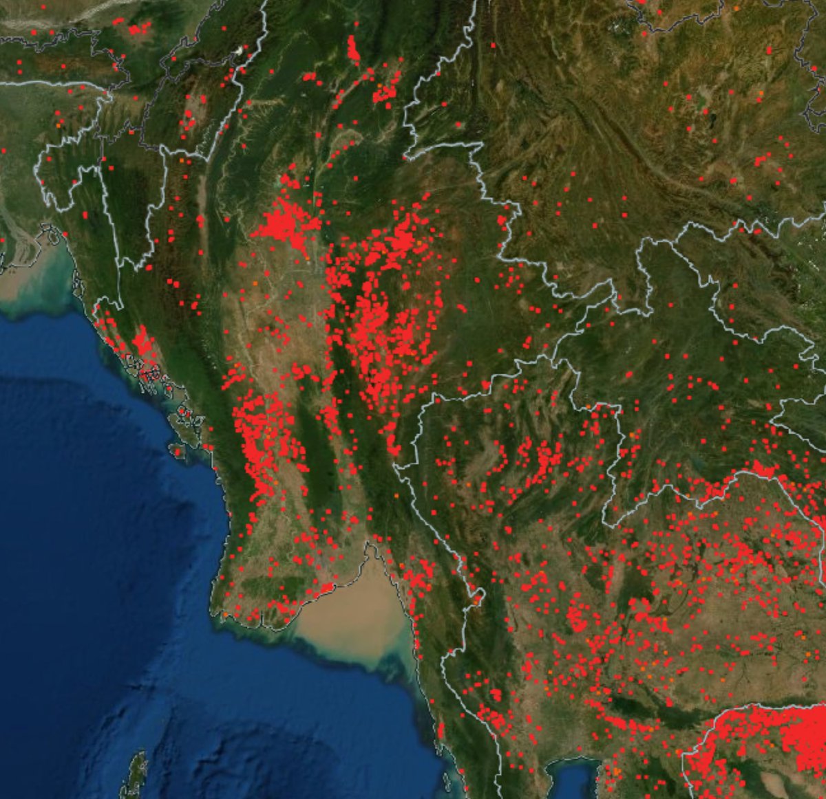
🚨BURNT BODIES
#WhatsHappeningInMyanmar
17 claims involving the burning of victims or their bodies in Myanmar (July 2021 - August 2022).
This list is not exhaustive and includes some credible but unverified claims where further evidence is required.
A thread👇TW//GRAPHIC
#WhatsHappeningInMyanmar
17 claims involving the burning of victims or their bodies in Myanmar (July 2021 - August 2022).
This list is not exhaustive and includes some credible but unverified claims where further evidence is required.
A thread👇TW//GRAPHIC

#WhatsHappeningInMyanmar
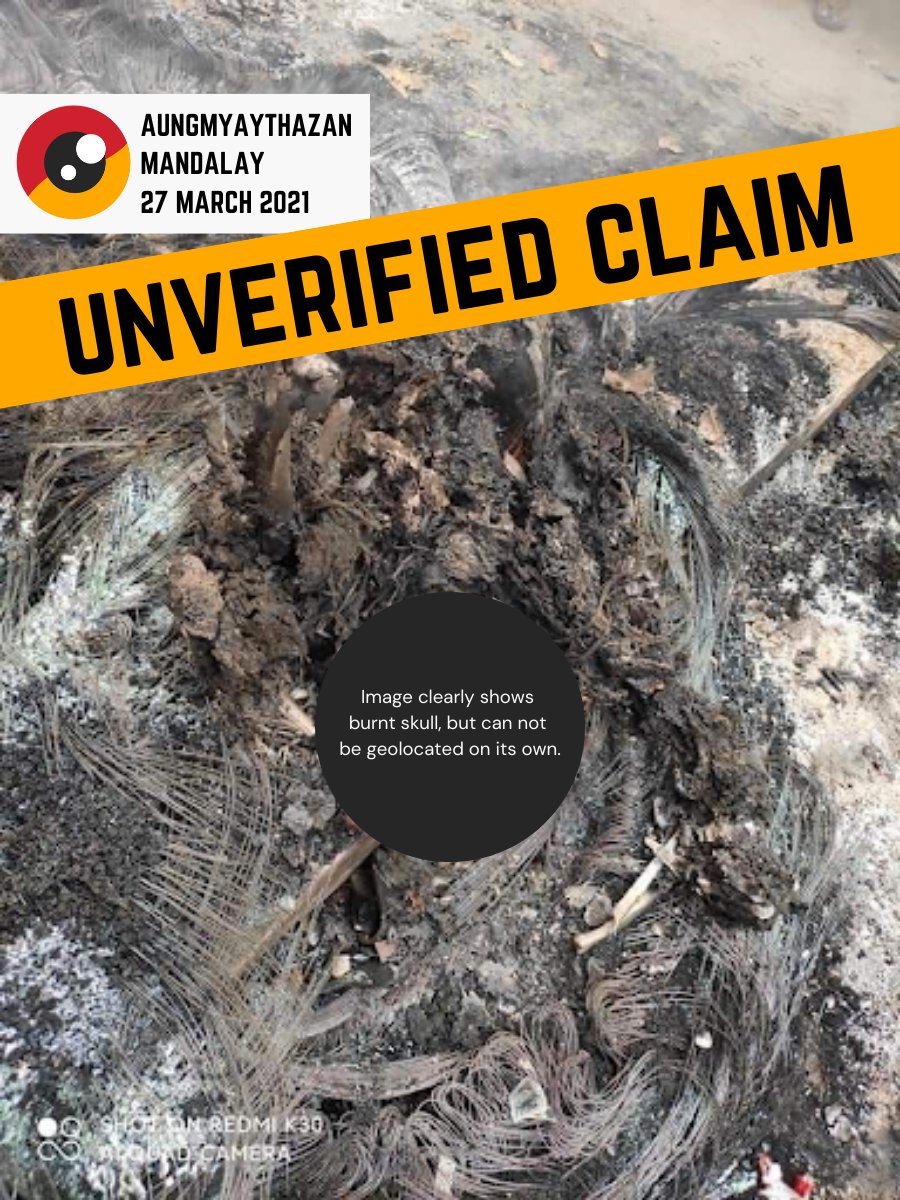
🔴 Burnt Bodies in Myanmar
🟡 Claim 1/17
Unverified media report
AUNGMYAYTHAZAN, Mandalay
27 March 2021
“Armed forces burnt a Mandalay resident alive”
myanmar-now.org/en/news/help-m…
Please upload evidence
myanmarwitness.org/upload-evidence
🔴 Burnt Bodies in Myanmar
🟡 Claim 1/17
Unverified media report
AUNGMYAYTHAZAN, Mandalay
27 March 2021
“Armed forces burnt a Mandalay resident alive”
myanmar-now.org/en/news/help-m…
Please upload evidence
myanmarwitness.org/upload-evidence
#WhatsHappeningInMyanmar
🔴 Burnt Bodies in Myanmar
🟡 Claim 2/17
✅ Geolocated images
KANI, Sagaing
28 JULY 2021
“The 11 men were massacred and set on fire”
Letter from Ambassador Kyaw Moe Tun
myanmarmissionnewyork.org/post/letter-fr…
“Multiple bodies”

🔴 Burnt Bodies in Myanmar
🟡 Claim 2/17
✅ Geolocated images
KANI, Sagaing
28 JULY 2021
“The 11 men were massacred and set on fire”
Letter from Ambassador Kyaw Moe Tun
myanmarmissionnewyork.org/post/letter-fr…
“Multiple bodies”
https://twitter.com/MayWongCNA/status/1421837364599541767?s=20

#WhatsHappeningInMyanmar
🔴 Burnt Bodies in Myanmar
🟡 Claim 3/17
✅ Verified
SALINGYI, Sagaing
7 December 2021
“Shouts and protests heard as the military shot and burned people to death in Don Taw village, Salingyi, Sagaing.” (Khitthit)
facebook.com/khitthitnews/p…
🔴 Burnt Bodies in Myanmar
🟡 Claim 3/17
✅ Verified
SALINGYI, Sagaing
7 December 2021
“Shouts and protests heard as the military shot and burned people to death in Don Taw village, Salingyi, Sagaing.” (Khitthit)
facebook.com/khitthitnews/p…

#WhatsHappeningInMyanmar
🔴 Burnt Bodies in Myanmar
🟡 Claim 4/17
✅ Verified
MOSO, Kayah
24 December 2021
35 victims were burnt alive.
Myanmar Witness geolocated and verified the incident.
myanmarwitness.org/reports/moso-v…
#MWReports
🔴 Burnt Bodies in Myanmar
🟡 Claim 4/17
✅ Verified
MOSO, Kayah
24 December 2021
35 victims were burnt alive.
Myanmar Witness geolocated and verified the incident.
myanmarwitness.org/reports/moso-v…
#MWReports

#WhatsHappeningInMyanmar
🔴 Burnt Bodies in Myanmar
🟡 Claim 5/17
Images of burnt bodies, not yet verified.
KHIN U, Sagaing
25 & 26 January 2022
“SAC militants burnt some dead bodies”
myanmar.liveuamap.com/en/2022/26-jan…
Please upload evidence
myanmarwitness.org/upload-evidence
#Myanmar
🔴 Burnt Bodies in Myanmar
🟡 Claim 5/17
Images of burnt bodies, not yet verified.
KHIN U, Sagaing
25 & 26 January 2022
“SAC militants burnt some dead bodies”
myanmar.liveuamap.com/en/2022/26-jan…
Please upload evidence
myanmarwitness.org/upload-evidence
#Myanmar

#WhatsHappeningInMyanmar
🔴 Burnt Bodies in Myanmar
🟡 Claim 6/17
✅ Verified
WETLET, Sagaing
3 Feb 2022
MW geolocated footage showing a number of burnt bodies just outside Thit Seint Gyi village. myanmarwitness.org/reports/verifi…
#MWReports #Myanmar #OSINT
🔴 Burnt Bodies in Myanmar
🟡 Claim 6/17
✅ Verified
WETLET, Sagaing
3 Feb 2022
MW geolocated footage showing a number of burnt bodies just outside Thit Seint Gyi village. myanmarwitness.org/reports/verifi…
#MWReports #Myanmar #OSINT

#WhatsHappeningInMyanmar
🔴 Burnt Bodies in Myanmar
🟡 Claim 7/17
Media report, unverified.
KANI, Sagaing
20 February 2022
“After the soldiers left, the PDF members found a burned body in the village.”
myanmar-now.org/en/news/junta-…
Upload evidence
myanmarwitness.org/upload-evidence
🔴 Burnt Bodies in Myanmar
🟡 Claim 7/17
Media report, unverified.
KANI, Sagaing
20 February 2022
“After the soldiers left, the PDF members found a burned body in the village.”
myanmar-now.org/en/news/junta-…
Upload evidence
myanmarwitness.org/upload-evidence

#WhatsHappeningInMyanmar
🔴 Burnt Bodies in Myanmar
🟡 Claim 8/17
Images of burnt bodies, not verified by MW.
KATHA, Sagaing
30 April 2022
“4 innocent villagers were burnt to death by the army”
Please upload evidence
myanmarwitness.org/upload-evidence
🔴 Burnt Bodies in Myanmar
🟡 Claim 8/17
Images of burnt bodies, not verified by MW.
KATHA, Sagaing
30 April 2022
“4 innocent villagers were burnt to death by the army”
https://twitter.com/Khithitofficial/status/1522842048852008960
Please upload evidence
myanmarwitness.org/upload-evidence

#WhatsHappeningInMyanmar
🔴 Burnt Bodies in Myanmar
🟡 Claim 9/17
✅ Verified burnt bodies were found
YE-U, Sagaing
10 May 2022
Claims that villagers found 27 burnt bodies.
facebook.com/khitthitnews/p…
Please DM related links / upload evidence at myanmarwitness.org/upload-evidence
🔴 Burnt Bodies in Myanmar
🟡 Claim 9/17
✅ Verified burnt bodies were found
YE-U, Sagaing
10 May 2022
Claims that villagers found 27 burnt bodies.
facebook.com/khitthitnews/p…
Please DM related links / upload evidence at myanmarwitness.org/upload-evidence

#WhatsHappeningInMyanmar
🔴 Burnt Bodies in Myanmar
🟡 Claim 10/17
Images of burnt bodies, unverified
KWEHTAUNT village
28 May 2022
It is claimed 2 men were shot and their bodies burnt.
Please upload evidence if safe to do so
myanmarwitness.org/upload-evidence
🔴 Burnt Bodies in Myanmar
🟡 Claim 10/17
Images of burnt bodies, unverified
KWEHTAUNT village
28 May 2022
It is claimed 2 men were shot and their bodies burnt.
https://twitter.com/LaMinMgMaung/status/1530492654558908418
Please upload evidence if safe to do so
myanmarwitness.org/upload-evidence

#WhatsHappeningInMyanmar
🔴 Burnt Bodies in Myanmar
🟡 Claim 11/17
Unverified media reports
CHAUNG U, Sagaing
18-20 June 2022
Five bodies found, some burnt according to RFA.
rfa.org/burmese/progra…
Please DM related links / upload evidence at myanmarwitness.org/upload-evidence
🔴 Burnt Bodies in Myanmar
🟡 Claim 11/17
Unverified media reports
CHAUNG U, Sagaing
18-20 June 2022
Five bodies found, some burnt according to RFA.
rfa.org/burmese/progra…
Please DM related links / upload evidence at myanmarwitness.org/upload-evidence

#WhatsHappeningInMyanmar
🔴 Burnt Bodies in Myanmar
🟡 Claim 12/17
Claim with related geolocated images
THATON, Mon
25 June 2022
Bodies of 3 villagers found in the ashes of burnt houses according to HURFOM.
Upload evidence
myanmarwitness.org/upload-evidence

🔴 Burnt Bodies in Myanmar
🟡 Claim 12/17
Claim with related geolocated images
THATON, Mon
25 June 2022
Bodies of 3 villagers found in the ashes of burnt houses according to HURFOM.
https://twitter.com/HURFOM/status/1551361202949083136
Upload evidence
myanmarwitness.org/upload-evidence

#WhatsHappeningInMyanmar
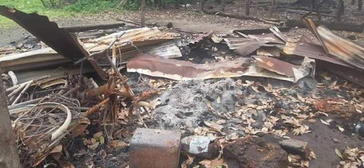
🔴 Burnt Bodies in Myanmar
🟡 Claim 13/17
Footage of burnt bodies
KYI SU, Sagaing
20 July 2022
Video filmed by a local resistance group shows burned bodies found in Kyi Su
myanmar-now.net/en/news/12-vil…
Upload further evidence
myanmarwitness.org/upload-evidence
🔴 Burnt Bodies in Myanmar
🟡 Claim 13/17
Footage of burnt bodies
KYI SU, Sagaing
20 July 2022
Video filmed by a local resistance group shows burned bodies found in Kyi Su
myanmar-now.net/en/news/12-vil…
Upload further evidence
myanmarwitness.org/upload-evidence

#WhatsHappeningInMyanmar
🔴 Burnt Bodies in Myanmar
🟡 Claim 14/17
Media report with unverified images
PAUK, Magway
28 July 2022
2 villagers shot in the mouth and their bodies burnt (Khitthit).
facebook.com/khitthitnews/p…
Please upload evidence
myanmarwitness.org/upload-evidence
🔴 Burnt Bodies in Myanmar
🟡 Claim 14/17
Media report with unverified images
PAUK, Magway
28 July 2022
2 villagers shot in the mouth and their bodies burnt (Khitthit).
facebook.com/khitthitnews/p…
Please upload evidence
myanmarwitness.org/upload-evidence

#WhatsHappeningInMyanmar
🔴 Burnt Bodies in Myanmar
🟡 Claim 15/17
Images of burnt bodies
DEPEYIN, Sagaing
11 August 2022
It is claimed a civilian was burnt to death. facebook.com/myaelattathan/…
Please DM related links / upload evidence at myanmarwitness.org/upload-evidence
🔴 Burnt Bodies in Myanmar
🟡 Claim 15/17
Images of burnt bodies
DEPEYIN, Sagaing
11 August 2022
It is claimed a civilian was burnt to death. facebook.com/myaelattathan/…
Please DM related links / upload evidence at myanmarwitness.org/upload-evidence

#WhatsHappeningInMyanmar
🔴 Burnt Bodies in Myanmar
🟡 Claim 16/17
More footage required to verify
TETIM, Chin
14 August 2022
2 teenagers’ bodies reportedly recovered from burnt buildings. facebook.com/theirrawaddy/p…
Please DM links / upload evidence at myanmarwitness.org/upload-evidence
🔴 Burnt Bodies in Myanmar
🟡 Claim 16/17
More footage required to verify
TETIM, Chin
14 August 2022
2 teenagers’ bodies reportedly recovered from burnt buildings. facebook.com/theirrawaddy/p…
Please DM links / upload evidence at myanmarwitness.org/upload-evidence

#WhatsHappeningInMyanmar
🔴 Burnt Bodies in Myanmar
🟡 Claim 17/17
Claim with related geolocated images
YINMARBIN, Sagaing
14 August 2022
30 burnt bodies allegedly found in a truck.
MW geolocated the truck.
Upload evidence
myanmarwitness.org/upload-evidence
🔴 Burnt Bodies in Myanmar
🟡 Claim 17/17
Claim with related geolocated images
YINMARBIN, Sagaing
14 August 2022
30 burnt bodies allegedly found in a truck.
MW geolocated the truck.
https://twitter.com/MyanmarWitness/status/1560557856382132224
Upload evidence
myanmarwitness.org/upload-evidence

🚨Burning Bodies in Myanmar
#WhatsHappeningInMyanmar
Myanmar Witness are investigating the burning of victims and corpses in Myanmar.
To help us further our investigations, please upload evidence via our website if safe to do so.
👉myanmarwitness.org/upload-evidence
#WhatsHappeningInMyanmar
Myanmar Witness are investigating the burning of victims and corpses in Myanmar.
To help us further our investigations, please upload evidence via our website if safe to do so.
👉myanmarwitness.org/upload-evidence
• • •
Missing some Tweet in this thread? You can try to
force a refresh


