Myanmar Witness Profile picture
Aug 29, 2022 10 tweets 5 min read Read on X
🔴 Lay Kay Kaw
🟡 Report out soon

Lay Kay Kaw (လေးကေ့ကော်) in Kayin (ကရင်) State, once designated a ‘town of peace’, has been the site of violent clashes between the Myanmar military and the Karen National Union (KNU), since December 2021.

#WhatsHappeningInMyanmar
THREAD 👇 ImageImage
Instead of providing a site of refuge to Internally Displaced Persons (IDPs), returning refugees and KNU families, fighting in Lay Kay Kaw (လေးကေ့ကော်) has forced many residents to flee for their lives. Image
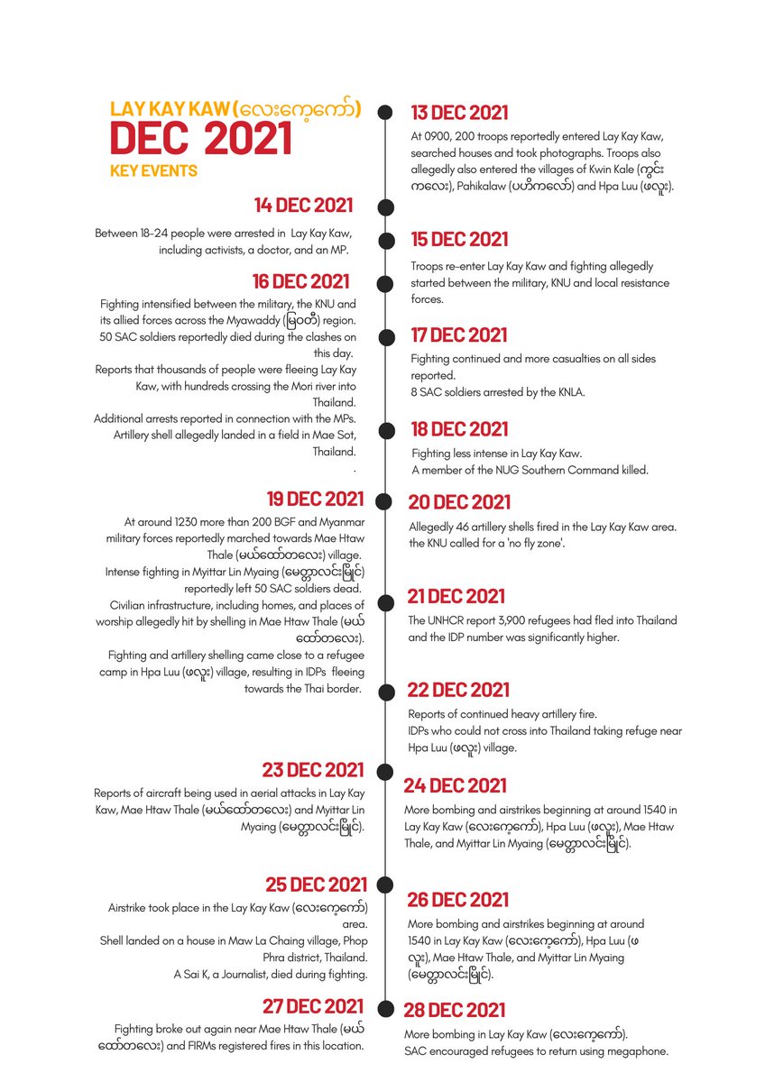
MW have published the first in a series of reports that document events in the region. It provides a detailed chronological reconstruction of the clashes between the military and oppositional forces between 13 and 28 December 2021. Image
Myanmar Witness has assessed claims found on social media and within Burmese news media that the military are responsible for the conflict in the region during this period. Image
This includes allegations that the military used excessive force, including heavy artillery within civilian areas; undertook potentially unjustified arrests, and incited violence and fighting. Image
By the end of December 2021, The Office of the United Nations High Commissioner for Refugees (UNHCR) reported that the violence had caused the mass displacement of up to 4,600 people. Image
Many casualties have been reported, including at least one non-combatant journalist between 15-28 December 2022. The location of this violence is particularly contentious as it lies at the border with Thailand, placing a strain on cross-border relations. Image
Myanmar Witness believes with high likelihood that the Myanmar military were present in Lay Kay Kaw (လေးကေ့ကော်) during December 2021. ImageImage
There is evidence to suggest that the military were responsible for the violent clashes, and also for the resultant displacement of civilians, some of which crossed the border into Thailand. ImageImageImage
Violent clashes have since continued in this area, leading to further displacement and destruction.

This will be explored further in forthcoming reports.

Check our website myanmarwitness.org for the full Lay Kay Kaw report out soon. Image

• • •

Missing some Tweet in this thread? You can try to force a refresh
 

Keep Current with Myanmar Witness

Myanmar Witness Profile picture

Stay in touch and get notified when new unrolls are available from this author!

Read all threads

This Thread may be Removed Anytime!

PDF

Twitter may remove this content at anytime! Save it as PDF for later use!

Try unrolling a thread yourself!

how to unroll video
  1. Follow @ThreadReaderApp to mention us!

  2. From a Twitter thread mention us with a keyword "unroll"
@threadreaderapp unroll

Practice here first or read more on our help page!

More from @MyanmarWitness

Sep 8, 2022
#WhatsHappeningInMyanmar
#MWFires

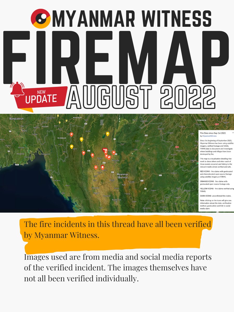
Fires continue to be used to destroy civilian property and entire villages in Myanmar, with devastating consequences for those that live there.

Below are 17 SERIOUS FIRE INCIDENTS added to the MW Fire Map in August 2022.

(THREAD) 👇
🚨Village burnt following clashes
☑️ Kale, Sagaing
☑️ 23.09851, 94.01889
☑️ 05 Aug 2022

firms.modaps.eosdis.nasa.gov/map/#t:adv;d:2…

facebook.com/khitthitnews/v…

#MWFires #Myanmar
🚨Thantlang burning again
☑️ Hakha, Chin
☑️ 22.6922, 93.42308
☑️ 06 Aug 2022

firms.modaps.eosdis.nasa.gov/map/#t:adv;d:2…

DM with links to footage if safe to do so.
#MWFires #Myanmar
Read 19 tweets
Sep 2, 2022
#WhatsHappeninglnMyanmar
🔴How do we verify fire claims?
🟡Geolocation Walkthrough

On 29 August 2022, SGG News reported a fire in Taung Myo village, Sagaing.

The disturbing images led MW investigators to try to verify the report, starting with geolocating the footage.

THREAD👇 Image
#OSINT #Geolocation

After initial assessment, it was possible to determine that several images showed the same location but were taken from a different angle.

When different images contain overlapping information, that can be a good place to start the geolocation work. ImageImageImageImage
Investigators often rely on satellite imagery for geolocation.

Analysis of the roofs and roads in the images can yield valuable information. Roof aspects (size, colour, shape) can be compared with road layout to make a unique pattern MW can then look for in satellite imagery. Image
Read 11 tweets
Aug 24, 2022
🚨BURNT BODIES
#WhatsHappeningInMyanmar

17 claims involving the burning of victims or their bodies in Myanmar (July 2021 - August 2022).

This list is not exhaustive and includes some credible but unverified claims where further evidence is required.

A thread👇TW//GRAPHIC
#WhatsHappeningInMyanmar
🔴 Burnt Bodies in Myanmar
🟡 Claim 1/17
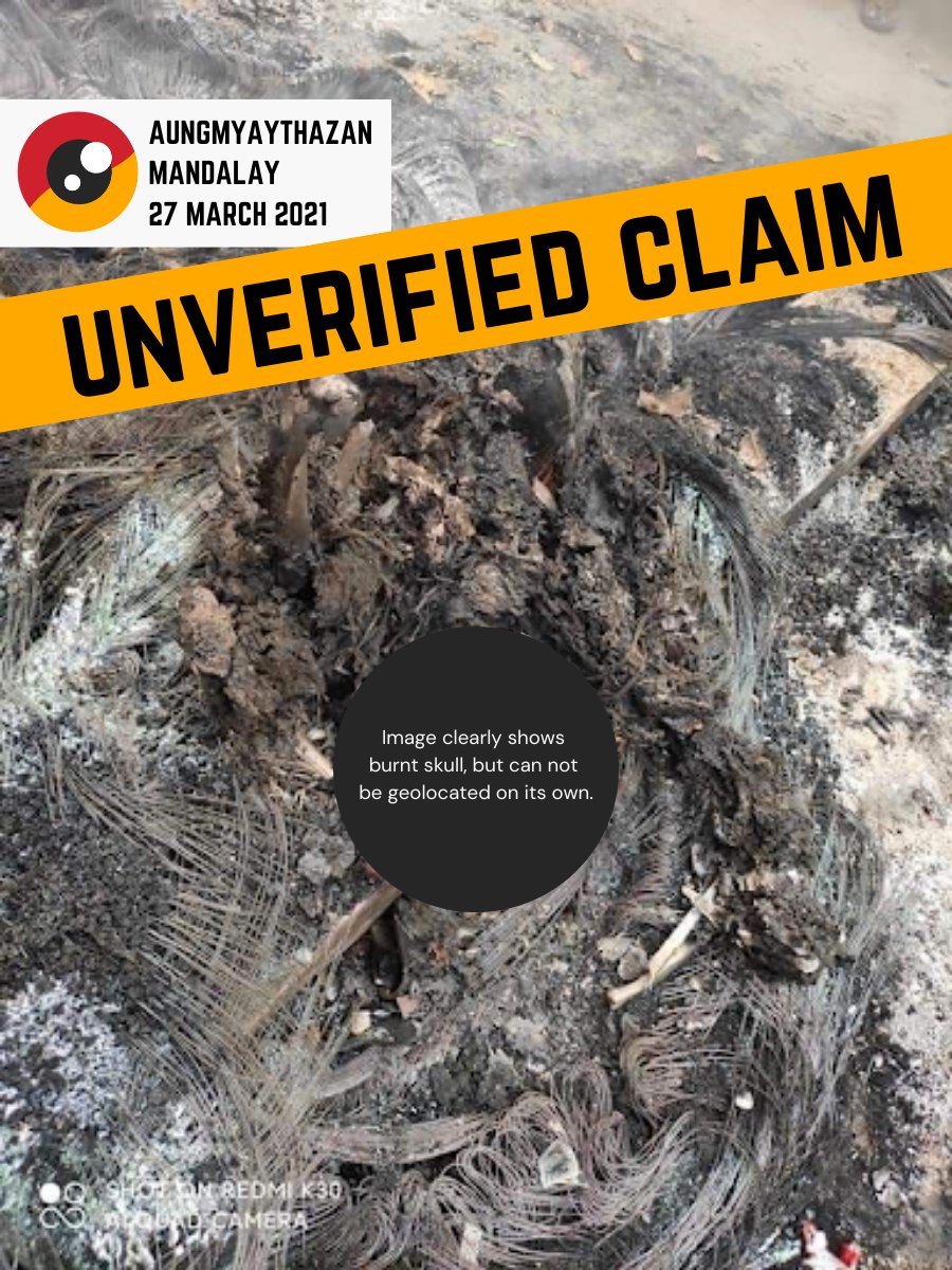
Unverified media report

AUNGMYAYTHAZAN, Mandalay
27 March 2021

“Armed forces burnt a Mandalay resident alive”
myanmar-now.org/en/news/help-m…

Please upload evidence
myanmarwitness.org/upload-evidence
#WhatsHappeningInMyanmar
🔴 Burnt Bodies in Myanmar
🟡 Claim 2/17
✅ Geolocated images

KANI, Sagaing
28 JULY 2021

“The 11 men were massacred and set on fire”
Letter from Ambassador Kyaw Moe Tun
myanmarmissionnewyork.org/post/letter-fr…

“Multiple bodies”
Read 19 tweets
Aug 17, 2022
🚨Vehicle Burning
...can seem insignificant when compared to other reports of #WhatsHappeningInMyanmar.

But vehicles
+ give freedom of movement
+ transport goods
+ often most-valued possession

When they are burnt it often reveals important clues to what happened.

Thread👇 Image
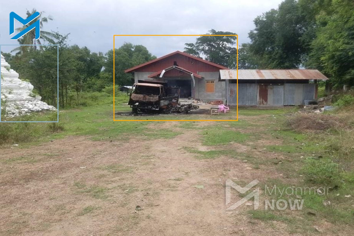
🚨Burnt vehicles
☑️Yinmarbin, Sagaing
☑️22.073197, 94.789316
☑️14 August 2022

A truck and motorcycles were burnt, following reports of a massacre in Yin Paung Taing village.

myanmar-now.org/en/news/the-sm… ImageImageImageImage
🚨Burnt truck
☑️Pwintbyu, Magway
☑️20.317129, 94.488443
☑️22 June 2022

We geolocated an image of a burnt truck, following reports of military activity in Pwintbyu. Image
Read 11 tweets
Feb 11, 2022
🔥 Documenting fires in Myanmar
#WhatsHappeningInMyanmar

Today we look at methods for documenting the burning of civilian structures.

There are several methods we can use to verify that a fire occurred, and then to map that damage.

#OSINT #THREAD

1/35 👇
Following reports of a village being burnt, the first thing that we try to do is verify the attack. For that we look for thermal anomaly detections from several satellites that orbit the globe twice per day. These are the VIIRS and Aqua/Terra Earth Observation satellites.
The data from these satellites regularly gets uploaded to a NASA website called FIRMS:
firms.modaps.eosdis.nasa.gov/map/#d:24hrs;@…

There are a lot of fires (mostly burning agricultural fields after harvest), but if you have specific info it is very useful to verify.
Read 35 tweets
Feb 10, 2022
မိမိဖုန်းကိုလုံခြုံအောင်ဘယ်လိုထားမလဲ……

ဖုန်းလုံခြုံရေးအတွက် အရေးကြီးတဲ့ အချက်များကို မျှဝေပေးချင်ပါတယ် 👇👇👇

1/7

#WhatsHappeningInMyanmar
#Myanmar #securityexplained
#MyanmarWitness
#ဒစ်ဂျစ်တယ်လုံခြုံရေး
#မိုဘိုင်းဖုန်းလုံခြုံရေး
Read 7 tweets

Did Thread Reader help you today?

Support us! We are indie developers!


This site is made by just two indie developers on a laptop doing marketing, support and development! Read more about the story.

Become a Premium Member ($3/month or $30/year) and get exclusive features!

Become Premium

Don't want to be a Premium member but still want to support us?

Make a small donation by buying us coffee ($5) or help with server cost ($10)

Donate via Paypal

Or Donate anonymously using crypto!

Ethereum

0xfe58350B80634f60Fa6Dc149a72b4DFbc17D341E copy

Bitcoin

3ATGMxNzCUFzxpMCHL5sWSt4DVtS8UqXpi copy

Thank you for your support!

Follow Us!

:(