[#NotYetAHurricaneKarl update Thread, waiting for sunrise ed. #ExtremeWeather #ClimateChangeNow ]
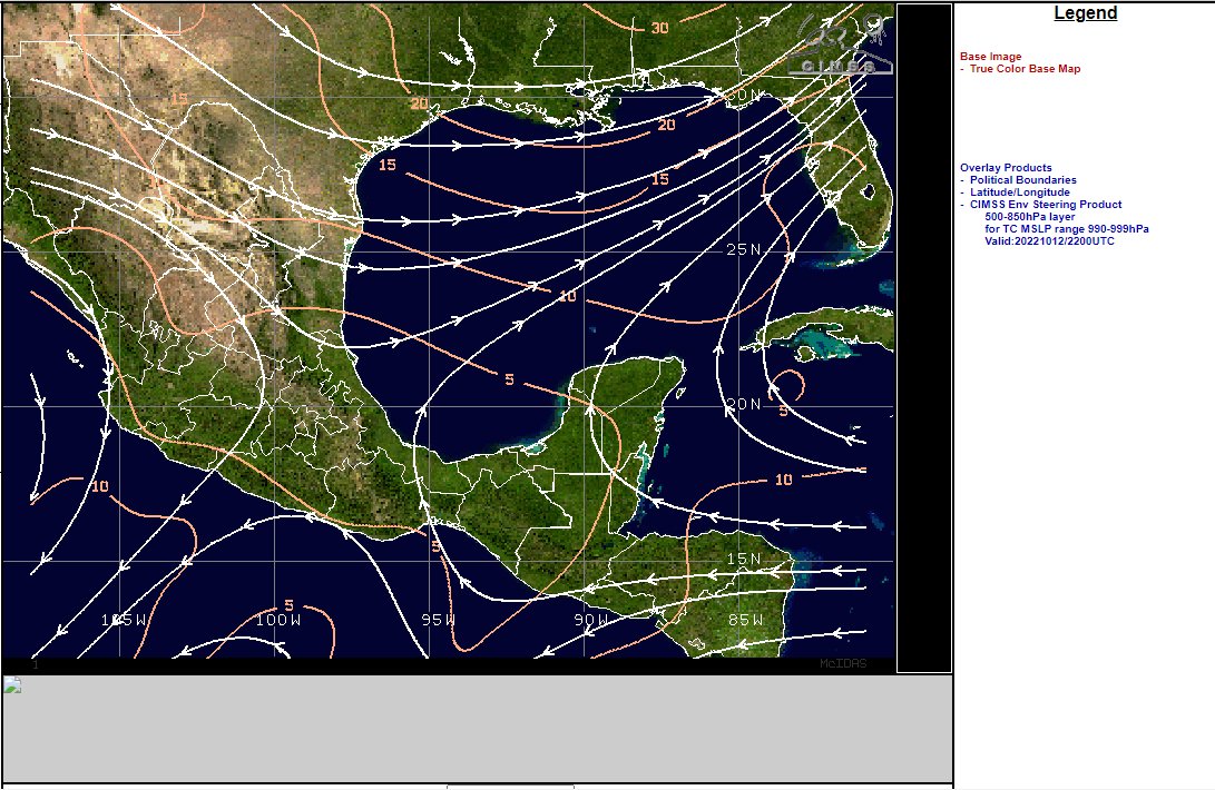
The ridge to the north of #Karl has moved south a fair bit and appears to be pushing #Karl to the south at the eastern edge of the offical NHC Track cone.
The ridge to the north of #Karl has moved south a fair bit and appears to be pushing #Karl to the south at the eastern edge of the offical NHC Track cone.
https://twitter.com/althecat/status/1580458294539603968
Here's another view where you can see the leading edge of the ridge that is pushing down on the hurricane capturing it near the entrance to the Tucanpecer's northern funnel.
Lookingclose at the last four hours @NHC_Atlantic may have a point about #NotYetAHurricane #Karl not quite yet being a hurricane - as predicted by the GFS it has collapsed and broadened out close to midnight as the models said.
That being said, the maximum sustained wind speed measure of what is and isn't a hurricane may need to be revised to deal with the hazard caused by extremely large Tropical Storms, Tropical Depressions and #Invest's which are difficult to measure and close to land.
Or in Karl's case not too close to land but combined with a very unusual weather pattern like an unprecedented arctic blast barrage over continental North America as is the case at the moment.
From a satellite absent @53rdWRS #NotYetAHurricane #Karl certainly looks like one.
From a satellite absent @53rdWRS #NotYetAHurricane #Karl certainly looks like one.
That said each of those lines of storms is caused by collisions between the dry air arctic blasts and tropical moisture, much of which probably originated with #Julia, #Karl and his sibling #99E which seems to be also making its way towards the Gulf now.
https://twitter.com/althecat/status/1579807362420191233?s=20&t=Q-GLEdS8U-j01Lf5BDp3-w
The thread quoted in the previous tweet discusses the Tehuantepecer wind-gap event that sliced #Julia in half and created the current situation - sibling storms on both coasts of Mexico, with separated by a cut offhigh pressure circulation, helping them to reinforce each other.
This updated animation is 6 later, when #Karl started to lose intensity after nightfall, #99E stopped moving closer and retreated towards the Pacific.
The next tweet will show a close up view.
#99E is a tropical disturbance, two rungs down from #Karl in cyclone hierarchy.
The next tweet will show a close up view.
#99E is a tropical disturbance, two rungs down from #Karl in cyclone hierarchy.
As promised, the sibling storms were getting fairly close before a drop in solar energy input led to #99E heading back towards the Pacific.
[ Meta Note: These graphics come from a great free, open science tool provided by the Cooperative Institute for Meteorological Satellite - Space Science and Engineering Center Studies at @UWMadison Wisconsin. Link: tropic.ssec.wisc.edu/# ]
They are built on amazing data feeds provided by @NOAA for the Atlantic via @NHC_Atlantic and the rest of the planet via the Joint Typhoon Warning Center (JTWC) a joint @USNavy – @usairforce command in Pearl Harbor, Hawaii.
Once a disturbance is declared to be of interest it is then tasked to one of several satellite systems to track GOES East in the Atlantic and Eastern Pacific (which is also under @NHC_Atlantic jurisdiction) Himawari-8 in the Western Pacific, and EUMETSAT (?) in the Indian Ocean.
At which point it becomes an #Invest and at that point you can use these tools to look at it.
And now back to the Gulf.
It looks as if #Karl is now being crushed between the Yucatan Peninsula and the ridge which is continuing to move south and starting to rip #Karl apart. Karl's southern edge is getting very close now to the entrance to the Tehuantepecer Wind Gap.
It looks as if #Karl is now being crushed between the Yucatan Peninsula and the ridge which is continuing to move south and starting to rip #Karl apart. Karl's southern edge is getting very close now to the entrance to the Tehuantepecer Wind Gap.
While I can see no obvious sign of rotation -this doesn't mean there isn't any. The hard bit with storms like #Julia and #Karl is identifying where the center is, or indeed if there is one. Sometimes it can even be over open sea & invisible.
Based on this diagram an watching these things far too much i'm going to hazard a guess that the intense convection we are seeing now is due to the sun rising early on clouds which could well be 3-4kms high. 

The @zoom_earth tool seems to have around 30 minutes delay and the data runs & processing which power CMISS can be even slower.
But fortunately we can find the live imagery we need via Dr. Levi Cowan's wonderful @TropicalTidbits [tropicaltidbits.com/sat/satlooper.…]
Thread fix..... to continue to follow this description click on the quoted thread below.
https://twitter.com/althecat/status/1580484762330103808?s=20&t=Y-iqvAd5B39VNSQjHj1GBA
Nope... click on this quoted thread to continue....
https://twitter.com/althecat/status/1580486224979951616?s=20&t=Y-iqvAd5B39VNSQjHj1GBA
@TropicalTidbits I would suggest you right click on this image and download it to see it properly as it contains a lot of fine detail, including at least three visible circulations at different altitudes plus the explosive burst at the leading edge.

@TropicalTidbits Here's the latest frame which is stamped 9.02Z = UTC/GMT = 4am in Mexico City but probaly about 6am where the storm is located, and about 8am at 5500m where the pink cloudtops you see here on the right.

If you right click and download the animation above this diagram will make a lot more sense - as you will be able to see these various circulations moving against each other.

The lowerl level circulations are interesting but not that important. What matters is the but that is airborn - not only - but that is the bit that has lots of mass and energy in it and therefore momentum - which is important here because we are trying to understand its motion.

What we have here is essentially two convective storms. One on the left and one on the right.
Storm Left: Is decaying its not nearly as high and as heavy.
Storm Right: Is dominant and shows us where the TS/Cyclone/hurricane is going.
Storm Left: Is decaying its not nearly as high and as heavy.
Storm Right: Is dominant and shows us where the TS/Cyclone/hurricane is going.


But before it does so it will have to get itself organised - and not get dragged or pushed into the Tehuantepecer Wind Gap. We now know that it is not being unduly affected by this "ridging feature" - if that is what it is -as it is clearly at a much lower altitude.

As for where the center is now, my guess is that it is roughly speaking here. Between the old core and the new core that is now developing.

Which puts #NotYetAHurricane #Karl well away from where the #NHC forecast says he ought to be at the moment. And far enough away and active enough to potentially move out of the range of the Tehuantepecer Wind Gap, regardless when the arctic blast actually arrives.

However, my analysis is completely at odds with @NHC_Atlantic's whose advice everyone ought to follow. I have highlighted the important top level conclusions in their latest advisory here. 1/2


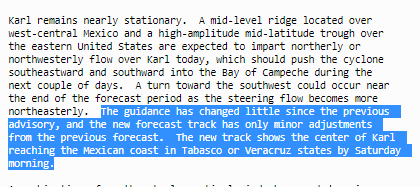
2/2
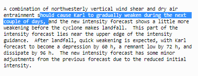

In response though I would say simply this. Since the inception of #Invest91L, which later became #HurricaneJulia showed extraordinary capacity to strengthen rapidly, dissapate and reform in the warm waters of the Carribean, and #Karl yesterday exhibited a similar propensity.
Sunrise is still a few hours away and thanks to open data, satellite imagery and free accessible online tools it is possible to monitor the storm now in real time on your phone, and not only the presentation but also the underlying data.
The extreme unpredictabiliity and explosive intensification capacity of this particular storm means that it is worth watching closely. To do so my main visual tool is @zoom_earth which is a web-app that works extremely well on a mobile phone.
Coffee...
/Ends
@Threadreaderapp unroll
@Threadreaderapp unroll
This link will take you straight to a near live satellite animation feed of #KARL on your mobile device >> zoom.earth/#view=22.3927,…
• • •
Missing some Tweet in this thread? You can try to
force a refresh