Daniel Swain Profile picture
Jan 11 4 tweets 3 min read
Additional widespread precipitation is likely over the next 8-9 days over the northern 2/3 of CA, and it will be heavy at times (especially northern third of CA). Strongest storm, with some more heavy rain, wind, and thunderstorms, is due in on Sat. #CAwx #CAwater [1/4] Projected precipitation map from ECMWF ensemble depicting wi
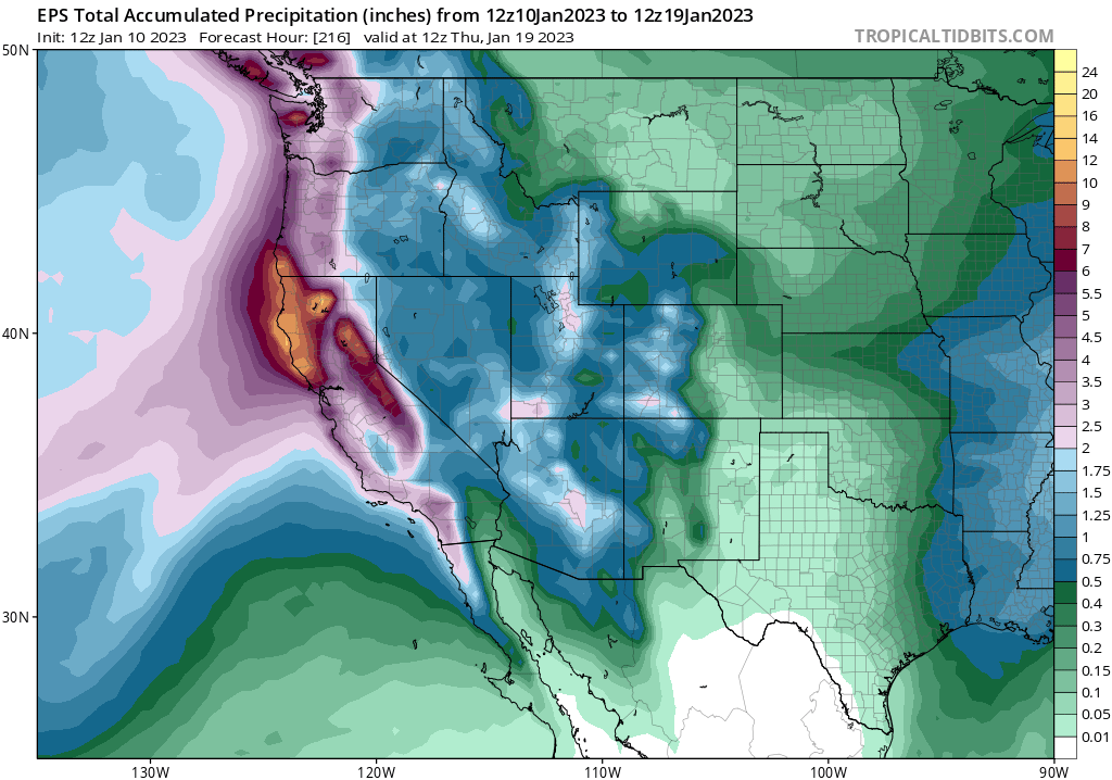
However, these are primarily areas that have not been nearly as wet as central CA recently. Also, these will generally be colder storm systems, bringing a greater balance of snow (vs rain) in mountains & somewhat limiting higher elevation runoff. #CAwx #CAwater [2/4]
For these reasons, although there will be *some* additional flooding, it increasingly look like *most* of CA will probably thread the needle--thereby avoiding a more widespread/severe flood scenario. Massive Sierra snowfalls are possible during this period! #CAwx #CAwater [3/4]
And there is now a plausible end in sight: multi-model ensembles continue to suggest a return to a West Coast ridge pattern in about 9-10 days (by Jan 20)--probably giving folks a much-needed chance to dry out and dig out. #CAwx #CAwater [4/4] Map of projected 500mb GPH anomalies from the ECMWF ensemble

• • •

Missing some Tweet in this thread? You can try to force a refresh
 

Keep Current with Daniel Swain

Daniel Swain Profile picture

Stay in touch and get notified when new unrolls are available from this author!

Read all threads

This Thread may be Removed Anytime!

PDF

Twitter may remove this content at anytime! Save it as PDF for later use!

Try unrolling a thread yourself!

how to unroll video
  1. Follow @ThreadReaderApp to mention us!

  2. From a Twitter thread mention us with a keyword "unroll"
@threadreaderapp unroll

Practice here first or read more on our help page!

More from @Weather_West

Jan 2
Okay, folks. Starting to look like it's going to be a rough 10+ days from a flood risk perspective in Northern California, with a series of very wet & high-impact storms. Brief thread now; blog post late this PM; YouTube live Q&A Tue. [1/n] #CAwx #CAwater
The next inbound storm looks like it will be quite strong. A rapidly deepening surface low (i.e., meteorological "bomb cyclone") will remain well offshore, but the associated warm and cold fronts will bring widespread heavy rain and strong winds to NorCal later Wed. #CAwx [2/n] Map showing ECMWF model representation of "bomb cyclone
This storm would be fairly notable in its own right, as it will be associated with an unusually well-defined warm *and* cold frontal passages and an exceptionally moist and relatively warm #AtmosphericRiver. #CAwater #CAwx [3/n] Map depicting ECMWF representation of Wednesday storm, inclu
Read 17 tweets
Dec 29, 2022
Some thoughts on impacts from ongoing and likely prolonged very wet spell in NorCal. (Short thread). TL;DR: widespread heavy precipitation is likely, with mostly minor flood issues becoming more widespread this weekend & *possibly* more significant next week. [1/n] #CAwx #CAwater
Lighter precipitation continues today, but the next significant storm will be this weekend. This will come in the form of a moderately strong low pressure system coupled with a robust, warm, and relatively slow-moving atmospheric river. #CAwx #CAwater [2/n] Image
This New Year's storm will bring heavy rainfall to essentially all of NorCal, and widespread precipitation to SoCal as well. This storm will be quite warm, too, with very high freezing levels initially bringing rain even at 7,000 feet. #CAwx #CAwater [3/n] Precipitation map from ECMW...
Read 8 tweets
Dec 20, 2022
Still not seeing many images of damage, but based on anecdotes from folks in quake zone it does sound like there was damage to some structures & especially to infrastructure. I suspect that ongoing widespread regional power outages are reason we haven't heard more yet.#earthquake
This points to an emerging paradox in media reporting on disasters that's become really apparent in recent years: the more severe the damage, the less news initially makes it out (because power is out and telecoms are down) and the less coverage they receive.
In our hyper-connected information era, it often feels like there's a presumption that if something was a big deal, it must be prominent on social media (& if it's not, it's not a big deal). But that assumption breaks down if people can't get online in the worst-affected areas...
Read 5 tweets
Dec 20, 2022
To @JFrancisClimate's point, there has been some interesting recent work suggesting that amplified Arctic warming may be causing the *stratospheric* polar vortex to become disrupted more often in winter. But this is still the topic of very active research. science.org/doi/10.1126/sc…
And there's further evidence that Arctic warming may be associated w/jet stream patterns favorable for warm season weather extremes. So my view is that there is something going on! It just doesn't appear to be manifesting as colder winter extremes. science.org/doi/10.1126/sc…
BTW, my personal/professional view, essentially informed speculation, is actually that we're going to eventually confirm that Arctic amplification/sea ice/snow cover/high lat ocean temperature forcings are quite important in certain regions/seasons (including California!).
Read 4 tweets
Dec 19, 2022
The upcoming Arctic outbreak across Central U.S. is going to be the "real deal". Temperatures will likely rival anything seen in 30 years (or even longer!) across portions of the Central Plains. In a warming climate, that's saying quite a lot. #COwx #NEwx #WYwx #KSwx (1/6) Map depicting predicted tem...
Temperatures will fall, in incredibly dramatic fashion ( of the course of just a few hours) by 40 or more degrees in some areas as a powerful Arctic front pushes through. Temperatures will plummet well below zero (-20 to -30F) across a broad region, w/even lower windchills. (2/6) Map depicting predicted dep...
This level of cold will be potentially dangerous even in places accustomed to pretty low temperatures in winter, since even those spots haven't seen temperatures this low in 30 or more years. This will be especially true across portions of Wyoming and Colorado. #WYwx #COwx (3/6) Map depicting the predicted...
Read 6 tweets
Oct 7, 2022
Latest seasonal predictions from NMME/IMME ensembles out today. Overall North Pacific pattern still looks very #LaNina-like: unusually wet PacNW and BC; unusually dry in SoCal & Lower Colorado Basin due to persistent NE Pacific ridging. HOWEVER... #WAwx #CAwx #AZwx (1/4) Maps of seasonal prediction...Image
...However, exact position of N. Pac. ridge is key. Too far east, & CA stays dry, but far enough west & Sierra benefits from cold storms diving south. High confidence in winter ridge, but CA will be on razor's edge--exact position will dictate dry vs wet overall. (2/4)#CAwx
This is why seasonal prediction is hard. It's quite likely models are correct about strong, anomalous North Pacific ridge signal (mainly due to #LaNina). But that doesn't directly translate to CA precip--it only offers a modest tilt in odds toward dry winter. #CAwx #CAwater (3/4)
Read 6 tweets

Did Thread Reader help you today?

Support us! We are indie developers!


This site is made by just two indie developers on a laptop doing marketing, support and development! Read more about the story.

Become a Premium Member ($3/month or $30/year) and get exclusive features!

Become Premium

Don't want to be a Premium member but still want to support us?

Make a small donation by buying us coffee ($5) or help with server cost ($10)

Donate via Paypal

Or Donate anonymously using crypto!

Ethereum

0xfe58350B80634f60Fa6Dc149a72b4DFbc17D341E copy

Bitcoin

3ATGMxNzCUFzxpMCHL5sWSt4DVtS8UqXpi copy

Thank you for your support!

Follow Us on Twitter!

:(