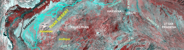
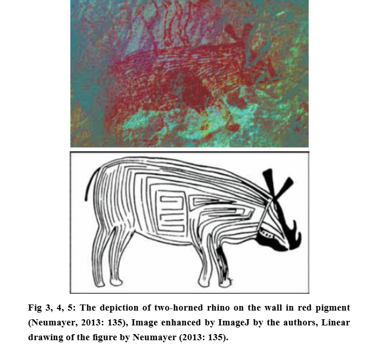
#Thread Indus Gadd 1932 Seals found in UR, a Sumerian city in ancient Mesopotamia, at the site of modern Tell el-Muqayyar in south Iraq's
Impressive Professional quality Pic by @britishmuseum. @NationalMissio1 & @ASIGoI should learn from British Museum. #Archaeology
1/14
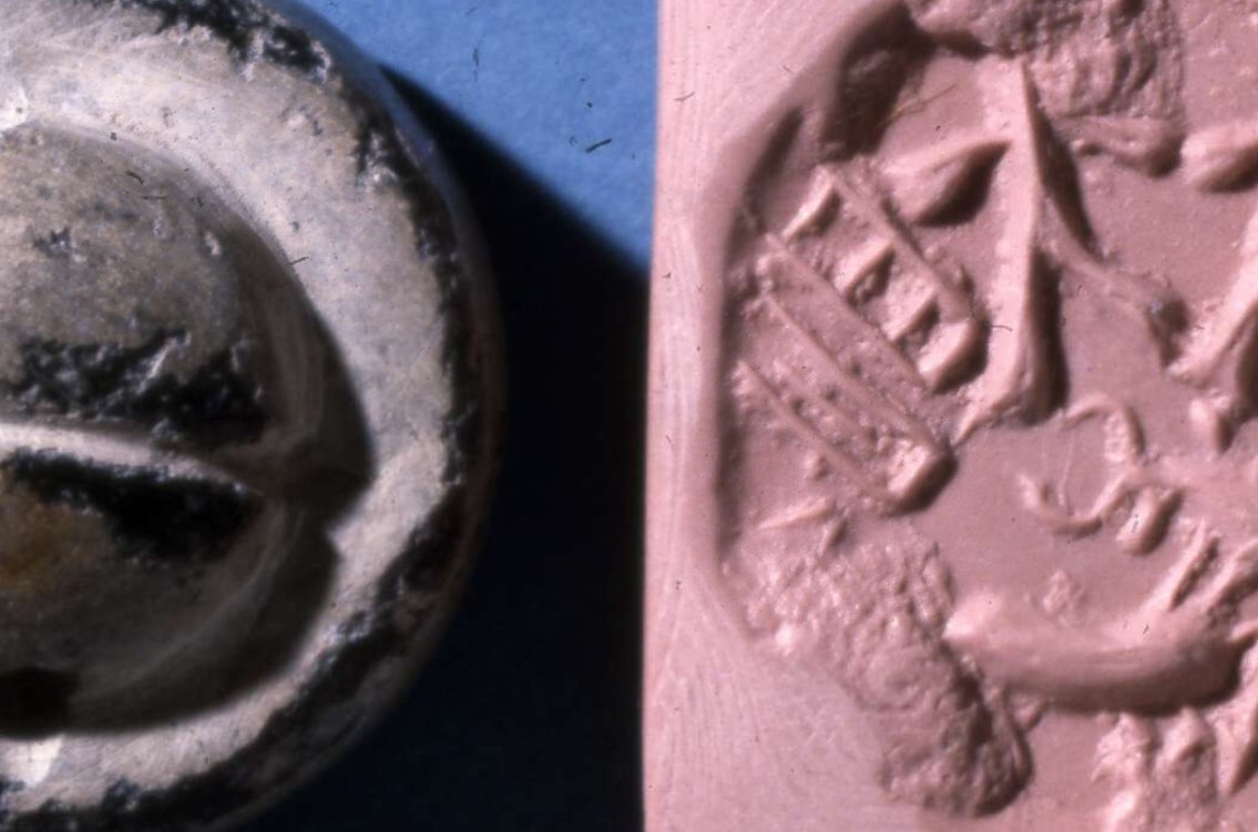
A palm-tree with humped bull (zebu), serpent, scorpion and recumbent human figure at the top in this Dilmun Period seal found in 1930 in UR #Archaeology
2/14
Circular stamp-seal of glazed white steatite; engraved with design showing a bull standing over a manger; Indus inscription along the top; top of domed reverse broken.
2500 BC-2000 BC
Babylon (Iraq) #Archaeology
3/14
Circular, dark green steatite stamp seal with pierced, centrally grooved lug at top, base engraved with inscription in Indus script above a humped bull facing right; one side badly chipped. #Archaeology
4/14
Greenish-grey steatite Dilmun-type stamp seal with creamy glaze; circular with convex top; double hole pierced through top; engraved with design on base divided into quadrants of four seated figures round periphery; section of base broken away. #Archaeology
5/14
Black glazed steatite stamp seal; circular; Gulf type and/or Indus Valley style; domed handle at top with groove along centre; hole pierced through at base of handle; design deeply engraved on base of figures and animals; chipped. #Archaeology
6/14
Rectangular, green-grey mottled steatite stamp-seal with pierced lug at back; front surface deeply engraved with crude design of bull standing, facing left; single line inscribed line above; Indus style seal with Sumerian inscription. #Archaeology
7/14
Fragment of a circular greenish-grey steatite stamp seal; part of an inscription and incised design on base; button boss top. #Archaeology
8/14
Circular light grey glazed steatite seal; base engraved with design of a bull facing right, with single-line inscription in Indus script above; roughly conical grooved button boss on top; hole pierced through base of button bosson; broken one side with section missing
9/14
Dark grey glazed steatite stamp seal; circular with domed top; Gulf-type; hole pierced through top; design engraved of scorpion and bull on face; complete. #Archaeology
10/14
Fragment of a pale brown glazed steatite stamp seal; circular with domed handle at top; hole pierced through base of handle; inscription and illegible design on base; lower and left hand part broken away. #Archaeology
11/14
Circular stamp-seal of black steatite, partially covered with a kind of glaze, Dilmun type; with face incised on top; hole pierced through top; geometric or animal design engraved on base. #Archaeology
12/14
Circular, light grey steatite stamp-seal; hole pierced through back; Dilmun type; face shows engraved design of two men, each dressed in a long skirt, walking left and clutching a jar between them; left figure grasps a leaping gazelle by the neck. #Archaeology
Diwali: diyas blaze during Kartik's darkest new moon (late Oct/early Nov).
Hanukkah: 8 candles in December.
Christmas: trees glow on Dec 25.
Yule, Dongzhi, Saturnalia... all cluster around winter solstice.
Why? 𝐇𝐮𝐦𝐚𝐧𝐬 𝐟𝐞𝐚𝐫 𝐝𝐚𝐫𝐤𝐧𝐞𝐬𝐬. 🕯️
2/ Rome, 217 BCE: Saturnalia begins Dec 17.
For one week, social order inverts. Slaves dine first. Masters serve. Courts close, gambling's allowed. Gifts exchanged: candles, wax figurines, pottery.
It celebrated Saturn's mythical "Golden Age"—a world without hierarchy.
Then normal life resumed.
3/ Fast-forward to 4th-century Rome: Christianity spreads.
Challenge: populations cling to winter festivals—Saturnalia, Sol Invictus (Dec 25 "Unconquered Sun"), local traditions.
Solution: 𝐚𝐝𝐚𝐩𝐭, don't erase.
Dec 25 becomes Christmas. Bible's silent on the date. Shepherds in fields suggest spring.
🧵 THREAD: Sambhar Lake didn’t become salty by accident.
It is the chemical footprint of the Aravallis. 🧂⛰️
Erase the hills, and the lake doesn’t shrink.
It dies.
#SaveAravalli
@narendramodi @PMOIndia @mygovindia @TVMohandasPai @CPCB_OFFICIAL @PIB_India @moefcc 1/
Sambhar Lake sits at the NE edge of the Aravalli Range.
This is not coincidence.
It is a tectonic basin formed along ancient Aravalli fault lines.
No Aravallis → no Sambhar.
Simple geology. Ignored policy.
2/ The Aravallis are ~3.2–2.5 billion years old.
Among the oldest folded mountains on Earth.
Sambhar exists because these rocks fractured, weathered, subsided.
Deep time created today’s salt.
1/ #GemsofASI #2 : British ASI manuals still rule India.
Not symbolically. Institutionally.
India became independent in 1947.
Its archaeology did not.
The Archaeological Survey of India still operates on conservation doctrines framed between 𝟏𝟗𝟎𝟒–𝟏𝟗𝟑𝟖, designed for colonial governance—not for a living civilisation.
#Decolonisation
2/ The 𝐀𝐧𝐜𝐢𝐞𝐧𝐭 𝐌𝐨𝐧𝐮𝐦𝐞𝐧𝐭𝐬 𝐏𝐫𝐞𝐬𝐞𝐫𝐯𝐚𝐭𝐢𝐨𝐧 𝐀𝐜𝐭, 𝟏𝟗𝟎𝟒 wasn’t written to protect Indian culture.
It was written to **control it**.
Its goals were explicit:
• Centralise authority
• Isolate monuments from locals
• Treat ritual use as damage
• Convert living sites into silent ruins
This logic never left ASI.
3/ British conservation doctrine insisted:
“Preserve the monument in the condition in which it is found.”
In Europe, that meant stabilising already-dead ruins.
In India, it meant 𝐟𝐫𝐞𝐞𝐳𝐢𝐧𝐠 𝐥𝐢𝐯𝐢𝐧𝐠 𝐭𝐞𝐦𝐩𝐥𝐞𝐬 𝐦𝐢𝐝-𝐛𝐫𝐞𝐚𝐭𝐡.
1/9 Ever hear of the Santhal Hul? Two years BEFORE the 1857 "Sepoy Mutiny" that history books love to call India's "first war of independence," the Santhal tribes rose up in 1855 against British exploitation. This was pure grassroots fury – bows and arrows vs. an empire. Let's dive in. 🏹
2/9 Background: The British "invited" Santhals to clear forests in the Rajmahal Hills (Damin-i-Koh, now Jharkhand/Bihar/WB) for farming and revenue. Sounded good – until zamindars, moneylenders (mahajans), and corrupt officials turned it into a nightmare. Debt traps, land grabs, exorbitant interest, forced labor. Santhals called outsiders "dikus" – exploiters.
3/9 The spark: Brothers Sidhu and Kanhu Murmu (plus Chand, Bhairav, and sisters Phulo & Jhano) claimed divine visions from Thakur Bonga (their god) commanding them to rebel and establish Santhal rule. On June 30, 1855, at Bhognadih village, 10,000+ Santhals gathered, took oaths, and declared war on the dikus.
ASI was founded in 1861, not to protect India’s past—but to manage it.
The Archaeological Survey of India was created by the British Empire, staffed by military engineers, and embedded inside colonial administration. The name "Survey" itself says it all.
This matters.
2/ ASI’s first Director General, Alexander Cunningham, was a Royal Engineers officer.
His training was not in living cultures.
It was in surveying, mapping, classification, and control.
Archaeology was an imperial tool.
3/ The mandate was clear:
• Identify ruins
• Catalogue monuments
• Standardise interpretation
• Detach sites from communities
A living civilisation is unpredictable.
Ruins are manageable.
🧵🏰 What kind of fort gets called "minor" at 2,700 feet with multi-tiered defences visible for miles?
The kind that didn't fit colonial narratives. Rayadurgam Fort, Anantapur — massive, sophisticated, erased.
We're still using their textbooks. The stones outlasted empires. The lie outlasted the stones.
#GemsofASI MNI#20
1/15
🛕 Built by 𝐉𝐮𝐧𝐠𝐚 𝐍𝐚𝐲𝐚𝐤𝐚 (1520s–30s), this was a Vijayanagara frontier fort controlling movement between AP & Karnataka. Colonial historians later downgraded it as "minor". Minor? A 2,700-ft citadel controlling two regions. But the empire narrative couldn't accommodate decentralised power. So it became "minor".
2/15
⛰️ At ~𝟐,𝟕𝟐𝟕 𝐟𝐭, Rayadurgam was built for surveillance: long-range visibility, multi-tiered access paths, natural cliffs turned to defence. But British-era archaeology catalogued it under 'regional ruins'. Right — altitude high, curiosity low. Classic imperial scholarship.