Vitaly Profile picture
Jun 9 β€’ 4 tweets β€’ 3 min read Twitter logo Read on Twitter
#Map fortifications and roads
Probably under impression after previous πŸ‡ΊπŸ‡¦ operations πŸ‡·πŸ‡Ί decided to concentrate their efforts on the roads, ignoring underdeveloped direction of Azov Upland.

@Nrg8000 map Image
@Nrg8000 Logic of πŸ‡·πŸ‡Ί fortifications is next
1. Protect hubs (crossroads and storages)
2. Protect the elevation (force the enemy to go always uphill)
3. Protect the Black Sea Lowland access (fast track) ImageImageImage
The "welcome" eastern section requires too much efforts from the attacking side and will rely on maneuver defense.
The major obstacle is the infrastructure. Supply lines should stretch along the dirt roads and the closes exit in Bilmak is fortified. Image
Detailed look at the fortifications of Tokmak direction.

β€’ β€’ β€’

Missing some Tweet in this thread? You can try to force a refresh
γ€€

Keep Current with Vitaly

Vitaly Profile picture

Stay in touch and get notified when new unrolls are available from this author!

Read all threads

This Thread may be Removed Anytime!

PDF

Twitter may remove this content at anytime! Save it as PDF for later use!

Try unrolling a thread yourself!

how to unroll video
  1. Follow @ThreadReaderApp to mention us!

  2. From a Twitter thread mention us with a keyword "unroll"
@threadreaderapp unroll

Practice here first or read more on our help page!

More from @M0nstas

Jun 7
Flooded areas of Kherson, Hola Prystan and Krynky.

Comparing to the topographic map. ImageImageImageImage
Kherson main indicator is the roundabout in Korabel district.
Topography is not precise and show difference in 7-9m
Bohoroducka street is at 11m level

both are similarly flooded.

That show that elevation map isn't accurate for this but still useful.
https://t.co/TIpXbvRyWy twitter.com/i/web/status/1… Image
Hola Prystan is another example of misleading elevation, the dry zone is 2 meters lower than a flooded zone in the center of the town ImageImage
Read 4 tweets
May 25
Another 20 destroyed artillery units reported.
For some reason no talks about the reported artillery position strikes.

The first such event was reported at Jan 11, the next in Jan 27, next Mar 7, it has never been a consistent event.
Everything has changed in May. ImageImage
Other distinct categories in the reports are
S-300 - were reported several times
MLRS - there were only 3 cases, all in April
EW - 13 were hit in May 19,20 and reported constantly since April.

EW is a Special equipment category and it has spiked in March. Image
Artillery is the only combat component where πŸ‡ΊπŸ‡¦ has some advantage over πŸ‡·πŸ‡Ί.
When πŸ‡·πŸ‡Ί has a lot of stuff and can execute firewall strategy, πŸ‡ΊπŸ‡¦ can simply outshoot the enemy limiting their capabilities.
In order to overcome that πŸ‡·πŸ‡Ί will rely on aviation.

F16 would be handy. ImageImage
Read 4 tweets
May 24
Lapin APC leader
@GeoConfirmed
50.453339, 35.630437
FJ3J+84Q Glotovo, Belgorod Oblast, Russia

https://t.co/EtHgEXMorm twitter.com/i/web/status/1… Image
@GeoConfirmed Lapin the squadron commander
50.461037, 35.640967

@GeoConfirmed
ImageImage
@GeoConfirmed General had a nice 1.2km walk in Glotovo Image
Read 4 tweets
May 23
As far as I understand young republic didn't last for long. The results would be clear tomorrow.
Russia should deploy more troops from their reserves on the border to avoid this in future, diverting resources away from the battlefield.
Apparently russian isn’t concerned with the attack of BNR, so it will continue.
Image
That's the Grayvoron customs

Interesting outcome
Read 7 tweets
May 12
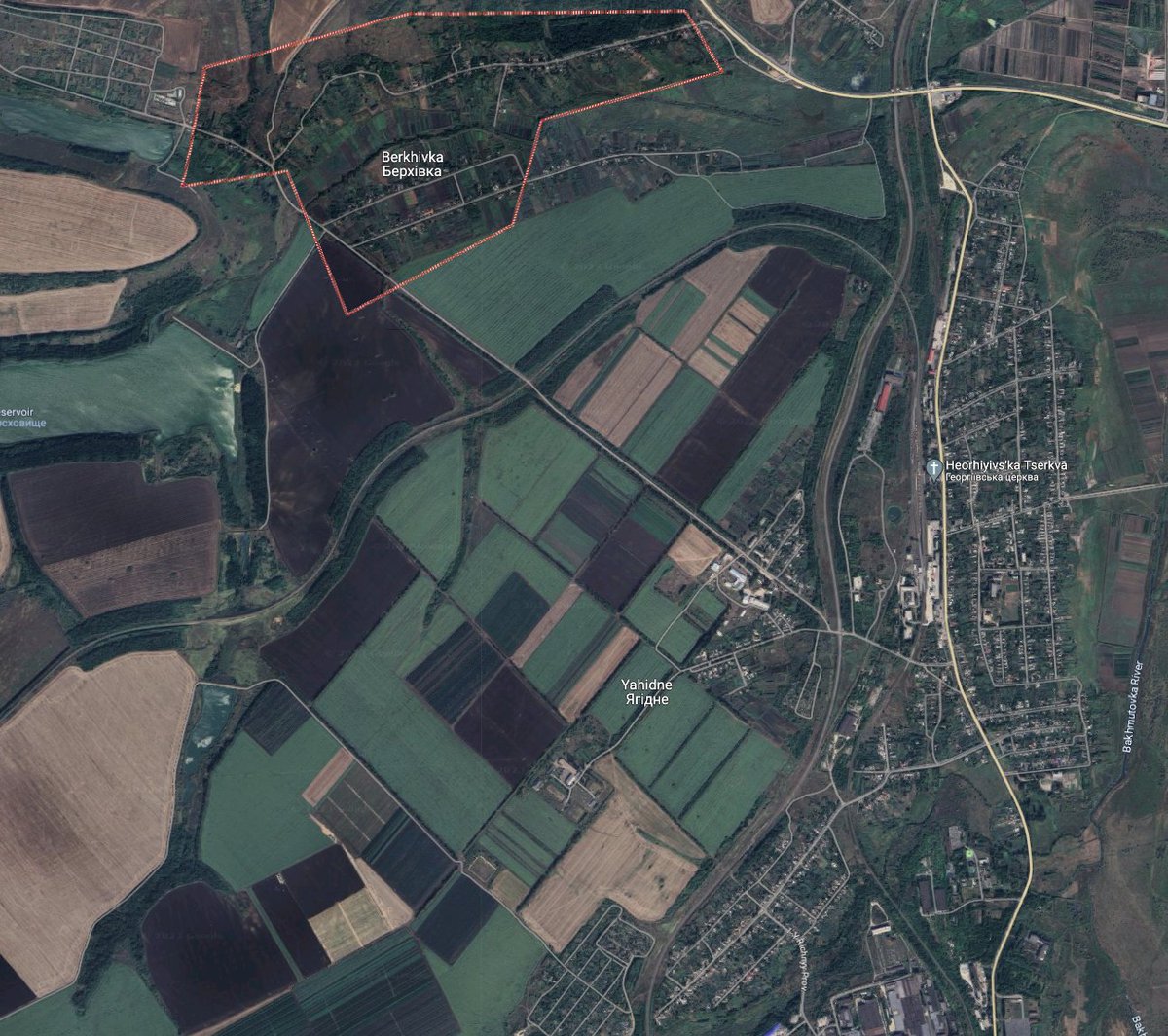
#Map Bakhmut madness
The topography at the west of Bakhmutka river provides some advantage for SE offense but at the end it favors those who is uphill.
The whole battlefield is 30km wide and 9 km deep so no deployment will hide.

*It’s made for entertainment. Image
1. Berkhivka hill.
It could be a good place for defense but fully exposed to the downhill attacks from the West and there are no positions to cover the area without exposure to the counter artillery. Can be used to launch an attack to a low ground.
2. Railroad between Berkhivka and Yahidne.
Position to control M03 and all the supply west of the river. The fields are smaller a assault tactics that was used by the russians may be used on the climb agains them on the fall. Image
Read 9 tweets
May 10
#Map #Klishchiivka pushback
First reported somewhat significant πŸ‡ΊπŸ‡¦ gain in a couple of months happens at the area where πŸ‡·πŸ‡Ί was struggling since capture of Kurdumivka.
The area is estimated from 2 to 8 kmΒ² and makes no difference.
What matters is momentum and positions.
0/X Image
Bakhmut is more than just a city - it's a lowland area east of the Donbas canal and offense can't stop on any point until canal is reached.
So πŸ‡·πŸ‡Ί should hold positions along the canal whatever the cost or start trading South and regroup.
1. πŸ‡ΊπŸ‡¦ recaptured area West of the canal - the main πŸ‡·πŸ‡Ί bridgehead, it also provides an access to the road, who controls it has a agility advantage over the enemy.
Control of the area cuts of the woods at the North, no more attacks over the canal.

Read 9 tweets

Did Thread Reader help you today?

Support us! We are indie developers!


This site is made by just two indie developers on a laptop doing marketing, support and development! Read more about the story.

Become a Premium Member ($3/month or $30/year) and get exclusive features!

Become Premium

Don't want to be a Premium member but still want to support us?

Make a small donation by buying us coffee ($5) or help with server cost ($10)

Donate via Paypal

Or Donate anonymously using crypto!

Ethereum

0xfe58350B80634f60Fa6Dc149a72b4DFbc17D341E copy

Bitcoin

3ATGMxNzCUFzxpMCHL5sWSt4DVtS8UqXpi copy

Thank you for your support!

Follow Us on Twitter!

:(