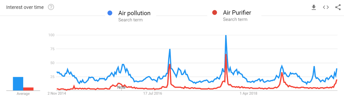
Like always Air Pollution becomes a topic of discussion when Delhi is facing it during crop fire season and it's eventually forgotten. Interestingly people also search for #AirPurifiers when #AirPollution also trends as shown in Google Search Trends
Along with private transport, industrial (including construction), power plants, Crop fires also play an important role in Delhi's pollution spikes.
Animation shows crop fires in #Punjab, #Haryana this season (VIIRS Data)
But are farmers to blame?
Crop fires' root cause is with our water management and crop selection practices (which themselves go back to green revolution era). Ever since green revolution, we have been planting more and more water intensive crops all over India. Punjab, Haryana are no different.
In order to prevent water depletion, government adjusted irrigation practices. This led farmers to plant these water intensive crops in quick succession. To clear the land, farmers are resorting to crop fires.
Hence to address the #cropfires issue, we have to address our irrigation and water management issues which have been plaguing our country in different forms.
Companies like @Flipkart , @amazonIN@amazon can procure the stubble for packaging and reduce the burden a bit too.
• • •
Missing some Tweet in this thread? You can try to
force a refresh
Google maps shows my GPS position to be well inside the sea in #Chennai Marina beach. But I was away from it. Why?
#Thread continuation of my previous one on Chennai #Marina beach 1/n
In the previous thread, I had explained how Marina beach is growing (sea becoming more and more land). Because of the longshore drift, lots of sand hence gets settled in the mouths of Cooum River.
To prevent further siltation in the mouth of the river, the government had built Groynes so that the capacity of the river doesn't get reduced.
#Thread
#Marina beach is one of the most iconic destinations in Chennai and one of the most visited beaches in the world. However the beach as we see today didn't exist a century ago.
This thread explains the formation of #Chennai's Marina beach 1/n
This map below shows the approximate original coastline of Chennai during British era. It was much closer to the Kamarajar road. A promenade was developed during the british era and that is when it got the name, "Marina". However the big sandy expanse itself didnt exist 2/n
Seas are very dynamic in nature. Whenever the waves hit the beach which is called as "swash", they bring in sand and when the water goes back ("backwash"), it removes the sand. This balance is critical for beach existence.
#Thread of #Maps that can help understand the #WayanadLandslide incident, its causes & impact
Please note that all the maps below were created with the information available as of now. Some of the damages outside the areas denoted might have been missed as info keeps coming
1. This part of #Wayanad is within the Chaliyar river system. It is a west flowing river which drains into the laccadive sea on Kerala coast (though at this part it is north and east flowing)
This map shows where the water drains. The area that is affected is shown in red.
2. In this particular section, the stream arises at around 2000 metres above mean sea level and has a steep fall of around 1200 m to reach Vellarmala, Chooralmala section.
#Thread
A collection of geographical myths & unknown facts about #Kanyakumari
1. Kanniyakumari is NOT the southern most point of mainland India, the southern most point is near star of the sea rock in nearby #Kovalam. In the last 20 years,it has been popularized as sunset point
2. Contrary to popular opinion, the three seas (Arabic Sea, Bay of Bengal, Indian Ocean) don't meet in Kanniyakumari.
Officially, the sea around Kanniyakumari district is Laccadive sea. Check map below for official extents of the seas and their names
3. Before 1956, Kanniyakumari was part of Travancore which pre-independence was a separate princely state. The South Travancore lines (a series of fortifications) were built to protect #Travancore. Currently, a small amount of this fortification is visible near Kanniyakumari
Here's a compilation of my #maps which can help you in understanding the #Bengaluru #Water situation a bit better.
Bengaluru is unofficially a hill station which is located nearly a kilometre above sea level.
Being in the top of a ridge line, the city is partly within Kaveri watershed and partly in Ponnaiyar (Dakshina Pinakini watershed).
Being on top, water from elsewhere dont flow through Bengaluru but flow outward from the city
Bengaluru right now depends on Kaveri river for water supply. Because of its height, Water is pumped for a height of 1000 feet from the river 100km away from the city
Here is the story of how @googlemaps helped me recover items stolen in a moving train from my father.
My father was travelling from Nagercoil to Trichy in sleper class in Nagercoil - Kacheguda express. He had boarded at 1:43 AM from NCJ. The train was relatively empty & another person who boarded along with my dad stole my dad's bag and mobile phone from him, and deboarded the train in Tirunelveli Junction.
When my dad realized it, he searched in the train and rang me from his friend's phone at 3:51 AM to inform that his phone was stolen. Luckily, among immediate family members we have location sharing "on" which meant I could track the location of mobile. When I checked it, I realized that the mobile was moving along the track near Melapalayam in Tirunelveli so I deduced that the thief was returning back to Nagercoil in another train.
I called my close friend Babin who is also a local DMK (@arivalayam) functionary to help me recover this. And we both went to Nagercoil station to catch the theif. The railway police listened to us and one of them came along. This is a snapshot of Google maps at the time when I was waiting railway station and the theif was still having my dad's phone.