#HurricaneDelta was the 25th named Atlantic storm of the 2020 hurricane season. After exhausting a list of prepared names, @WMO turns to the Greek alphabet to name storms.
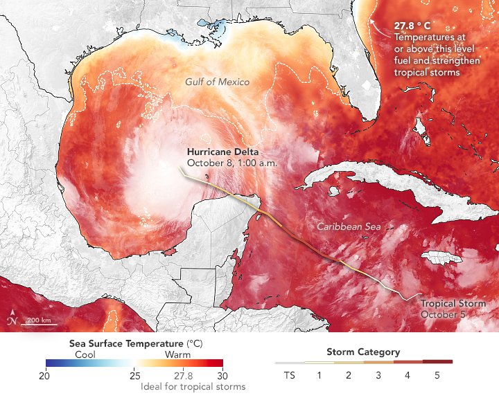
Hurricanes typically get a massive boost of energy when they pass over warm waters. #HurricaneDelta rapidly intensified to a Category 4 storm. #HurricaneLaura also underwent rapid intensification in the Gulf of Mexico.
go.nasa.gov/2GTxb7V Natural color satellite image of Hurricane Delta making landImage of Hurricane Delta making landfall with ocean colored
As it made landfall, #HurricaneDelta was generating heavy rainfall. Combining data from @NASARain’s satellites with computer models helps track precipitation to help those living in the storm’s path.
go.nasa.gov/3dlIXnr
As hurricanes continue to grow larger and more powerful, @NASA and @NOAA satellites track these storms from space to help improve forecasting and inform first responders on the ground.

• • •

Missing some Tweet in this thread? You can try to force a refresh
 

Keep Current with NASA Earth

NASA Earth Profile picture

Stay in touch and get notified when new unrolls are available from this author!

Read all threads

This Thread may be Removed Anytime!

PDF

Twitter may remove this content at anytime! Save it as PDF for later use!

Try unrolling a thread yourself!

how to unroll video
  1. Follow @ThreadReaderApp to mention us!

  2. From a Twitter thread mention us with a keyword "unroll"
@threadreaderapp unroll

Practice here first or read more on our help page!

More from @NASAEarth

21 Sep
Arctic sea ice reached its second-lowest minimum extent on record on Sept. 15, 2020. This year’s extent was larger only than 2012’s extent. @NASA and @NSIDC track sea ice through the year.
go.nasa.gov/33LwmFH
Sea ice plays an important role in keeping our planet cool. Light-colored ice reflects heat from the Sun back into the atmosphere, while darker ocean water absorbs it, so warming accelerates as sea ice extent declines.
Sea ice extent grows and shrinks with the seasons, with the colder northern winter temperatures freezing sea water and the warmer summer temperatures melting it. Over the last decades, sea ice extent has been trending smaller — a direct result of warmer global temperatures. ImageSea ice seen from a planeImageImage
Read 5 tweets
6 May
318 gigatons.
That’s how much ice is lost every year from Antarctica and Greenland’s ice sheets, according to new science from @NASA_Ice's #ICESat2. go.nasa.gov/3cb0bCC

But… how much ice is that, really? 🤔
Let's say 🧊= a gigaton of ice.

🧊 would be enough to cover NYC’s Central Park in ice past the top of the Chrysler Building. When melted, it would fill 400,000 Olympic-sized swimming pools.

Each year from 2003 to 2019, Greenland lost 200 🧊s. Antarctica lost 118 🧊s.
From 2003-2019, Greenland lost: 🧊🧊🧊🧊🧊🧊🧊🧊🧊🧊🧊🧊🧊🧊🧊🧊🧊🧊🧊🧊🧊🧊🧊🧊🧊🧊🧊🧊🧊🧊🧊🧊🧊🧊🧊🧊🧊🧊🧊🧊🧊🧊🧊🧊🧊🧊🧊🧊🧊🧊🧊🧊🧊🧊🧊🧊🧊🧊🧊🧊🧊🧊🧊🧊🧊🧊🧊🧊🧊🧊🧊🧊🧊🧊🧊🧊🧊🧊🧊🧊🧊🧊🧊🧊🧊🧊🧊🧊🧊🧊🧊🧊🧊🧊🧊🧊🧊🧊🧊🧊🧊🧊🧊🧊🧊🧊🧊🧊🧊🧊🧊🧊🧊🧊🧊🧊🧊🧊🧊🧊
Read 40 tweets
15 Jan
2019 was the second hottest 🌡 year and the last decade was the warmest decade on record. The global average temperature was more than 2°F warmer than during the late 19th century.
go.nasa.gov/2RnffDZ
Scientists at @NASA and @NOAA separately analyze temperature measurements taken at thousands of weather stations, ships and ocean buoys around the globe. Although the records differ slightly due to data processing, they both show a long-term pattern 📈 of increasing temperature.
The global temperature 🌎 is an average, so not every place on Earth had its second-warmest year. For instance, the continental U.S. had a cold October, but Alaska set records for high temperatures. The U.S. was still warmer than average over the year.
Read 6 tweets
9 Dec 19
Time-lapses 🎥 taken from space can help track how Earth’s polar ❄️ regions are changing, watching as glaciers retreat and accelerate and ice sheets melt over decades. #AGU19 #AGUCryo
go.nasa.gov/38kxAZW
Thanks to @USGS/@NASA_Landsat’s 🛰 long data record, we can watch Alaskan glaciers ❄️ shift and flow every year since 1972. Columbia Glacier, which was relatively stable in the 1970s, has since retreated rapidly as the climate continues to warm 🌡.
@USGS @NASA_Landsat The Malaspina Glacier has pulsed and spread and pulsed. The flashes 💥 and imperfect frames result from the need for cloud-free images 📷 from each year, and the technology limitations of the early generation satellites.
Read 8 tweets

Did Thread Reader help you today?

Support us! We are indie developers!


This site is made by just two indie developers on a laptop doing marketing, support and development! Read more about the story.

Become a Premium Member ($3/month or $30/year) and get exclusive features!

Become Premium

Too expensive? Make a small donation by buying us coffee ($5) or help with server cost ($10)

Donate via Paypal Become our Patreon

Thank you for your support!

Follow Us on Twitter!