JUST IN: NASA confirms that 2020 was the hottest year in recorded history – very slightly higher, though statistically indistinguishable from 2016.
https://twitter.com/NASAGISS/status/1349749596646420480
Several important things to note here.
The most important: The continuing long-term trend of catastrophic warming is what scientists are most concerned about. Not whether this year is a fraction of a degree above or below another year.
That trend is due to human activity.
The most important: The continuing long-term trend of catastrophic warming is what scientists are most concerned about. Not whether this year is a fraction of a degree above or below another year.
That trend is due to human activity.

If you break down the data by land vs ocean, you'll see another very important trend: Temperatures on land (where we all live) are warming faster than ocean temperatures.
Also, the data is much more clear: 2020 was the hottest year ever measured on our planet's continents.
Also, the data is much more clear: 2020 was the hottest year ever measured on our planet's continents.

The pattern of warming in 2020 is also very clear: The Arctic is warming much more quickly than the rest of the world. This year, parts of the Siberian Arctic were 6.6º Celsius (!) warmer than long-term average.
Large parts of the Earth (in bright red) have now warmed 2-4ºC.
Large parts of the Earth (in bright red) have now warmed 2-4ºC.

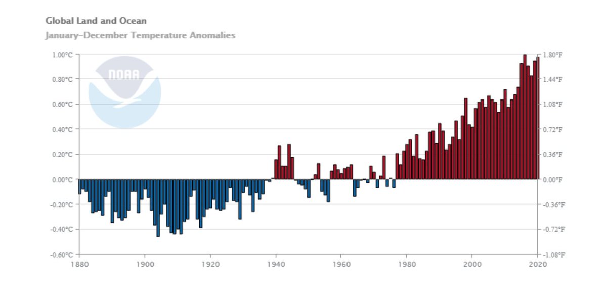
An independent analysis by @NOAA, also released today, shows that 2020 was the 2nd warmest year in history, very slightly cooler than 2016.
Again, the long-term trend is very clear: Every single year since 1977 has been warmer than the 20th century average.
Again, the long-term trend is very clear: Every single year since 1977 has been warmer than the 20th century average.

According to NOAA, "The seven warmest years in the 1880–2020 record have all occurred since 2014, while the 10 warmest years have occurred since 2005."
The decade of 2011-2020 was the hottest decade in recorded history.
The decade of 2011-2020 was the hottest decade in recorded history.

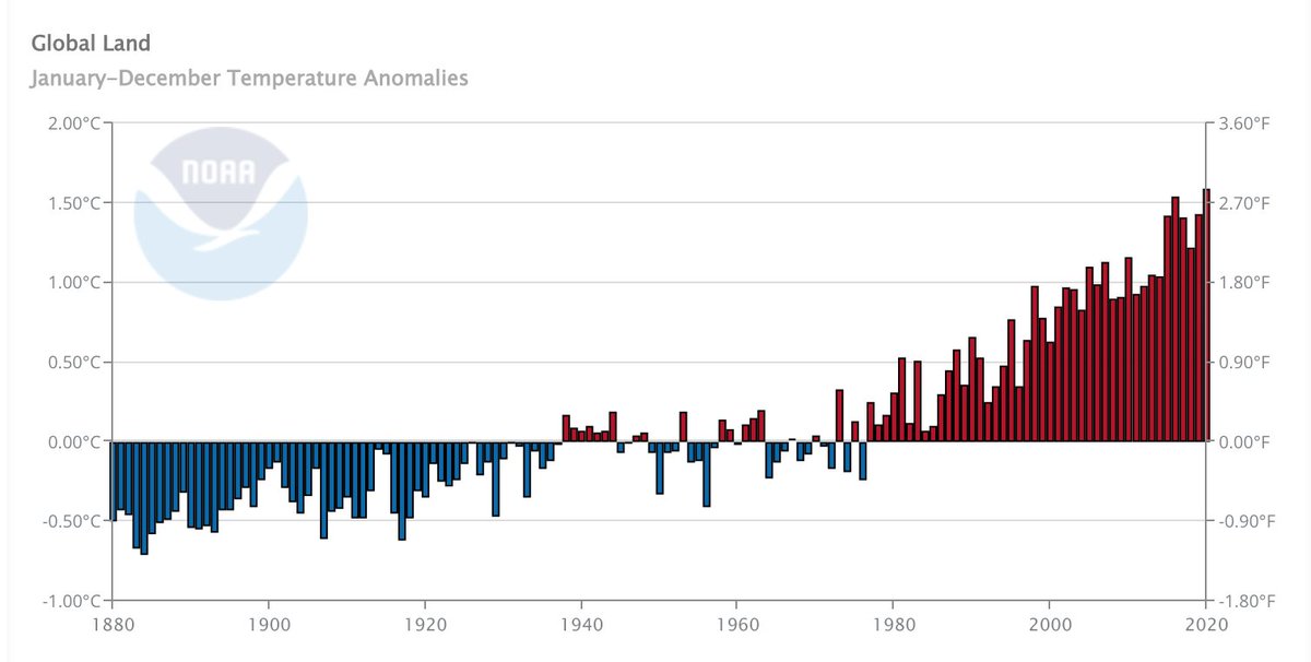
Looking only at land temperatures, NOAA agrees with NASA that 2020 was the hottest year ever recorded on the Earth's continents.
2016 and 2020 were the first two years in history with global land temperatures above the 1.5°C threshold.
2016 and 2020 were the first two years in history with global land temperatures above the 1.5°C threshold.

The only corners of the entire Earth's land area that were even slightly cooler than normal in 2020 were parts of Alaska and Canada, a small coastal section of Peru and Chile, a small part of Australia and South Africa, and a patch of South Asia.
Everywhere else was hot.
Everywhere else was hot.

The fastest warming places on the planet are warming by 0.5°C per *decade* – that's terrifying.
Northeast US and Atlantic Canada, Eastern Europe, the Middle East, and the entire Arctic region are at greatest risk of quickly rising temperatures.
We are in a climate emergency.
Northeast US and Atlantic Canada, Eastern Europe, the Middle East, and the entire Arctic region are at greatest risk of quickly rising temperatures.
We are in a climate emergency.

Looking ahead to 2021, it's almost certain that it will be slightly cooler than 2020 (because of La Niña), but it's also virtually certain that it will rank as one of the 10 hottest years in history.
We need to treat this like the emergency it is – like our lives depend on it.
We need to treat this like the emergency it is – like our lives depend on it.

• • •
Missing some Tweet in this thread? You can try to
force a refresh


